Poopó elevation
Poopó (Oruro), Bolivia elevation is 3756 meters and Poopó elevation in feet is 12323 ft above sea level [src 1]. Poopó is a populated place (feature code) with elevation that is 1880 meters (6168 ft) bigger than average city elevation in Bolivia.
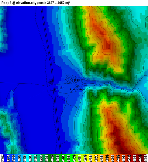
Below is the Elevation map of Poopó, which displays elevation range with different colors. Scale of the first map is from 3697 to 4652 m (12129 to 15262 ft) with average elevation of 3916.2 meters (=12848 ft) [note 1]
These maps also provides idea of topography and contour of this city, they are displayed at different zoom levels. More info about maps, scale and edge coordinates you can find below images.
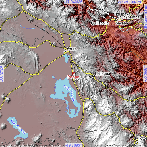
| \ | Map #1 | Topo.Map |
| Scale [m] | 3697..4652 m | × |
| Scale [ft] | 12129..15262 ft | × |
| Average | 3916.2 m = 12848 ft | × |
| Width | 9.27 km = 5.8 mi | 296.7 km = 184.4 mi |
| Height | 9.27 km = 5.8 mi | 296.8 km = 184.4 mi |
| ↑Max Latitude | -18.338552° | -17.04069° |
| Latitude at center | -18.38026° | -18.38026° |
| ↓Min Latitude | -18.421958° | -19.7095° |
| ← Min Longitude | -67.010895° | -68.3732° |
| Longitude center | -66.96695° | -66.96695° |
| →Max Longitude | -66.923005° | -65.5607° |
Nearby cities:
Cities around Poopó sort by population:
• Oruro elevation 3936 m
48.2 km,  336°
336°
• Llallagua 3897 m
40.7 km,  96°
96°
• Huanuni 3963 m
17.2 km,  53°
53°
• Challapata 3732 m
61.6 km,  160°
160°
• Capinota 2395 m
105.4 km, 45°
• Colquiri 4276 m
111.5 km,  351°
351°
• Irpa Irpa 2467 m
104.5 km, 45°
• Eucaliptus 3734 m
106 km,  326°
326°
• Machacamarca 3728 m
23.8 km, 346°
• Colquechaca 4170 m
107.6 km,  109°
109°
• Totoral 3900 m
16.2 km,  142°
142°
• Andamarca 3751 m
72.2 km,  232°
232°
Multilingual:
 En español:
Poopó elevación 3756 m.
 En France:
Poopó élévation 3756 m.


Sources and notes:
- [note 1] Map square and city borders are not equal. Map elevation data is calculated only from area inside that square.
- [src 1] Elevation data from geonames database provided with same terms of usage.
- [src 2] The elevation map of Poopó is generated using elevation data from NASA's 3 arcsec (90m) resolution SRTM data.
- [src 3] Base (background) map © OpenStreetMap contributors tiles are generated by Geofabrik and OpenTopoMap.
Copyright & License:
This Poopó Elevation Map is licensed under CC BY-SA. You may reuse any part from this page, if you give a proper credit by linking to this URL:
 More info on terms of use page.