Capinota elevation
Capinota (Cochabamba), Bolivia elevation is 2395 meters and Capinota elevation in feet is 7858 ft above sea level [src 1]. Capinota is a populated place (feature code) with elevation that is 519 meters (1703 ft) bigger than average city elevation in Bolivia.
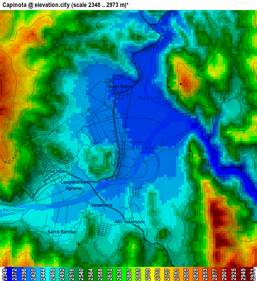
Below is the Elevation map of Capinota, which displays elevation range with different colors. Scale of the first map is from 2348 to 2973 m (7703 to 9754 ft) with average elevation of 2531.8 meters (=8306 ft) [note 1]
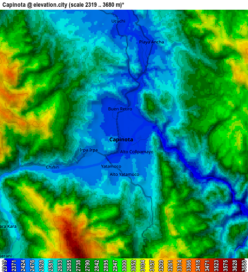
These maps also provides idea of topography and contour of this city, they are displayed at different zoom levels. More info about maps, scale and edge coordinates you can find below images.
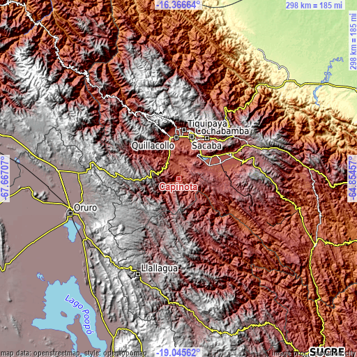
| \ | Map #1 | Map #2 | Topo.Map |
| Scale [m] | 2348..2973 m | 2319..3680 m | × |
| Scale [ft] | 7703..9754 ft | 7608..12073 ft | × |
| Average | 2531.8 m = 8306 ft | 2732 m = 8963 ft | × |
| Width | 9.31 km = 5.8 mi | 18.62 km = 11.6 mi | 297.9 km = 185.1 mi |
| Height | 9.31 km = 5.8 mi | 18.62 km = 11.6 mi | 297.9 km = 185.1 mi |
| ↑Max Latitude | -17.669263° | -17.627386° | -16.36664° |
| Latitude at center | -17.71113° | -17.71113° | -17.71113° |
| ↓Min Latitude | -17.752988° | -17.794835° | -19.04562° |
| ← Min Longitude | -66.304765° | -66.348711° | -67.66707° |
| Longitude center | -66.26082° | -66.26082° | -66.26082° |
| →Max Longitude | -66.216875° | -66.172929° | -64.85457° |
Nearby cities:
Cities around Capinota sort by population:
• Cochabamba elevation 2577 m
37.4 km,  17°
17°
• Sacaba 2710 m
42.1 km,  34°
34°
• Quillacollo 2559 m
35.5 km,  356°
356°
• Tiquipaya 2651 m
41.8 km,  6°
6°
• Punata 2731 m
48.9 km,  67°
67°
• Cliza 2726 m
37.4 km, 68°
• Tarata 2760 m
27.8 km, 65°
• Colomi 3444 m
58 km,  46°
46°
• Arani 2749 m
54.5 km, 73°
• Sipe Sipe 2717 m
31.8 km,  335°
335°
• Irpa Irpa 2467 m
0.9 km,  225°
225°
• Colchani 3411 m
65.3 km,  312°
312°
Multilingual:
 En español:
Capinota elevación 2395 m.
 En France:
Capinota élévation 2395 m.
 Auf Deutsch:
Capinota höhe über dem Meeresspiegel ist 2395 m.

Sources and notes:
- [note 1] Map square and city borders are not equal. Map elevation data is calculated only from area inside that square.
- [src 1] Elevation data from geonames database provided with same terms of usage.
- [src 2] The elevation map of Capinota is generated using elevation data from NASA's 3 arcsec (90m) resolution SRTM data.
- [src 3] Base (background) map © OpenStreetMap contributors tiles are generated by Geofabrik and OpenTopoMap.
Copyright & License:
This Capinota Elevation Map is licensed under CC BY-SA. You may reuse any part from this page, if you give a proper credit by linking to this URL:
 More info on terms of use page.