Andamarca elevation
Andamarca (Oruro), Bolivia elevation is 3751 meters and Andamarca elevation in feet is 12306 ft above sea level [src 1]. Andamarca is a seat of a second-order administrative division (feature code) with elevation that is 1875 meters (6152 ft) bigger than average city elevation in Bolivia.
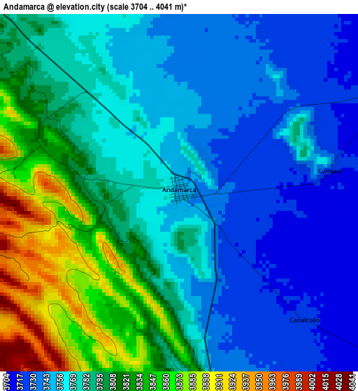
Below is the Elevation map of Andamarca, which displays elevation range with different colors. Scale of the first map is from 3704 to 4041 m (12152 to 13258 ft) with average elevation of 3782.7 meters (=12410 ft) [note 1]
These maps also provides idea of topography and contour of this city, they are displayed at different zoom levels. More info about maps, scale and edge coordinates you can find below images.
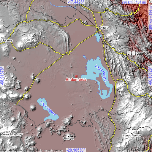
| \ | Map #1 | Topo.Map |
| Scale [m] | 3704..4041 m | × |
| Scale [ft] | 12152..13258 ft | × |
| Average | 3782.7 m = 12410 ft | × |
| Width | 9.25 km = 5.7 mi | 296 km = 183.9 mi |
| Height | 9.25 km = 5.7 mi | 296.1 km = 184 mi |
| ↑Max Latitude | -18.737729° | -17.4428° |
| Latitude at center | -18.77934° | -18.77934° |
| ↓Min Latitude | -18.820941° | -20.10536° |
| ← Min Longitude | -67.551475° | -68.91378° |
| Longitude center | -67.50753° | -67.50753° |
| →Max Longitude | -67.463585° | -66.10128° |
Nearby cities:
Cities around Andamarca sort by population:
• Oruro elevation 3936 m
96.2 km,  23°
23°
• Llallagua 3897 m
105 km,  67°
67°
• Huanuni 3963 m
89.4 km,  52°
52°
• Challapata 3732 m
78.8 km,  99°
99°
• Lahuachaca 3806 m
157.6 km,  353°
353°
• Eucaliptus 3734 m
133 km,  359°
359°
• Machacamarca 3728 m
84.8 km,  37°
37°
• Poopó 3756 m
72.2 km, 52°
• Totoral 3900 m
73.8 km,  64°
64°
• Curahuara de Carangas 3945 m
140.9 km,  316°
316°
• Cruz de Machacamarca 3726 m
96.7 km,  263°
263°
• Huachacalla 3753 m
79.4 km,  268°
268°
Multilingual:
 En español:
Andamarca elevación 3751 m.
 En France:
Andamarca élévation 3751 m.
 Auf Deutsch:
Andamarca höhe über dem Meeresspiegel ist 3751 m.

Sources and notes:
- [note 1] Map square and city borders are not equal. Map elevation data is calculated only from area inside that square.
- [src 1] Elevation data from geonames database provided with same terms of usage.
- [src 2] The elevation map of Andamarca is generated using elevation data from NASA's 3 arcsec (90m) resolution SRTM data.
- [src 3] Base (background) map © OpenStreetMap contributors tiles are generated by Geofabrik and OpenTopoMap.
Copyright & License:
This Andamarca Elevation Map is licensed under CC BY-SA. You may reuse any part from this page, if you give a proper credit by linking to this URL:
 More info on terms of use page.