Huarina elevation
Huarina (La Paz), Bolivia elevation is 3840 meters and Huarina elevation in feet is 12598 ft above sea level [src 1]. Huarina is a populated place (feature code) with elevation that is 1964 meters (6444 ft) bigger than average city elevation in Bolivia.
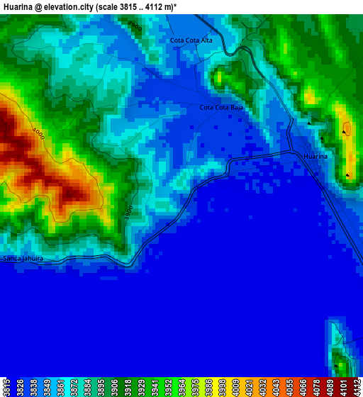
Below is the Elevation map of Huarina, which displays elevation range with different colors. Scale of the first map is from 3815 to 4112 m (12516 to 13491 ft) with average elevation of 3865 meters (=12680 ft) [note 1]
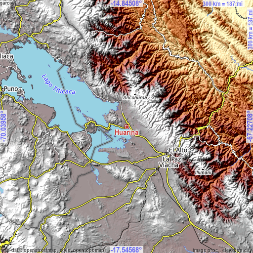
These maps also provides idea of topography and contour of this city, they are displayed at different zoom levels. More info about maps, scale and edge coordinates you can find below images.
| \ | Map #1 | Topo.Map |
| Scale [m] | 3815..4112 m | × |
| Scale [ft] | 12516..13491 ft | × |
| Average | 3865 m = 12680 ft | × |
| Width | 9.38 km = 5.8 mi | 300.3 km = 186.6 mi |
| Height | 9.38 km = 5.8 mi | 300.3 km = 186.6 mi |
| ↑Max Latitude | -16.157795° | -14.84508° |
| Latitude at center | -16.2° | -16.2° |
| ↓Min Latitude | -16.242196° | -17.54568° |
| ← Min Longitude | -68.677275° | -70.03958° |
| Longitude center | -68.63333° | -68.63333° |
| →Max Longitude | -68.589385° | -67.22708° |
Nearby cities:
Cities around Huarina sort by population:
• La Paz elevation 3782 m
61.4 km,  122°
122°
• Achacachi 3838 m
17.5 km,  342°
342°
• San Pedro 4013 m
23.6 km,  259°
259°
• Huatajata 3943 m
5.3 km,  270°
270°
• San Pablo 3931 m
21.4 km, 265°
• Tiahuanaco 3860 m
39.5 km,  187°
187°
• Batallas 3849 m
15.4 km,  136°
136°
• Yumani 3972 m
58 km,  288°
288°
• Coroico 1575 m
96.5 km,  89°
89°
• Sorata 2697 m
47.5 km,  357°
357°
• Coripata 1688 m
110.9 km,  95°
95°
• Guanay 477 m
112 km,  45°
45°
Multilingual:
 En español:
Huarina elevación 3840 m.
 En France:
Huarina élévation 3840 m.
 Auf Deutsch:
Huarina höhe über dem Meeresspiegel ist 3840 m.

Sources and notes:
- [note 1] Map square and city borders are not equal. Map elevation data is calculated only from area inside that square.
- [src 1] Elevation data from geonames database provided with same terms of usage.
- [src 2] The elevation map of Huarina is generated using elevation data from NASA's 3 arcsec (90m) resolution SRTM data.
- [src 3] Base (background) map © OpenStreetMap contributors tiles are generated by Geofabrik and OpenTopoMap.
Copyright & License:
This Huarina Elevation Map is licensed under CC BY-SA. You may reuse any part from this page, if you give a proper credit by linking to this URL:
 More info on terms of use page.