Tarabuco elevation
Tarabuco (Chuquisaca, Provincia Yamparáez), Bolivia elevation is 3293 meters and Tarabuco elevation in feet is 10804 ft above sea level [src 1]. Tarabuco is a seat of a fourth-order administrative division (feature code) with elevation that is 1417 meters (4649 ft) bigger than average city elevation in Bolivia.
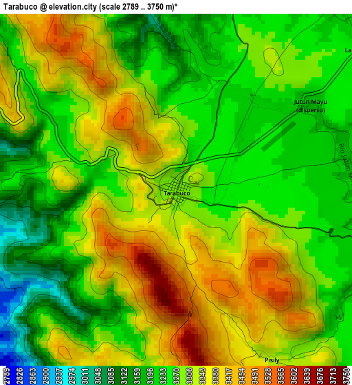
Below is the Elevation map of Tarabuco, which displays elevation range with different colors. Scale of the first map is from 2789 to 3750 m (9150 to 12303 ft) with average elevation of 3291.7 meters (=10800 ft) [note 1]
These maps also provides idea of topography and contour of this city, they are displayed at different zoom levels. More info about maps, scale and edge coordinates you can find below images.
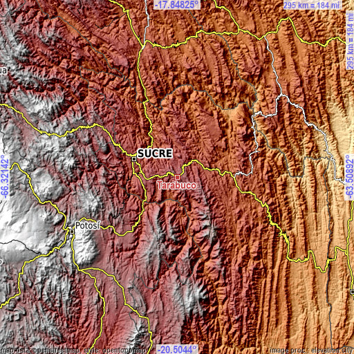
| \ | Map #1 | Topo.Map |
| Scale [m] | 2789..3750 m | × |
| Scale [ft] | 9150..12303 ft | × |
| Average | 3291.7 m = 10800 ft | × |
| Width | 9.23 km = 5.7 mi | 295.3 km = 183.5 mi |
| Height | 9.23 km = 5.7 mi | 295.4 km = 183.6 mi |
| ↑Max Latitude | -19.140169° | -17.84825° |
| Latitude at center | -19.18168° | -19.18168° |
| ↓Min Latitude | -19.22318° | -20.5044° |
| ← Min Longitude | -64.959115° | -66.32142° |
| Longitude center | -64.91517° | -64.91517° |
| →Max Longitude | -64.871225° | -63.50892° |
Nearby cities:
Cities around Tarabuco sort by population:
• Sucre elevation 2798 m
40.1 km,  294°
294°
• Potosí 3967 m
98.6 km,  243°
243°
• Mizque 2014 m
145 km,  342°
342°
• Vallegrande 2042 m
114.8 km,  47°
47°
• Monteagudo 1148 m
121.9 km,  124°
124°
• Aiquile 2258 m
112.2 km,  345°
345°
• Betanzos 3329 m
70 km,  233°
233°
• Comarapa 1818 m
146.5 km,  16°
16°
• Padilla 2091 m
65.8 km,  102°
102°
• Colquechaca 4170 m
126.4 km,  295°
295°
• Villa Serrano 2115 m
62.5 km,  84°
84°
• Yamparáez 3096 m
21.9 km,  267°
267°
Multilingual:
 En español:
Tarabuco elevación 3293 m.
 En France:
Tarabuco élévation 3293 m.
 Auf Deutsch:
Tarabuco höhe über dem Meeresspiegel ist 3293 m.

Sources and notes:
- [note 1] Map square and city borders are not equal. Map elevation data is calculated only from area inside that square.
- [src 1] Elevation data from geonames database provided with same terms of usage.
- [src 2] The elevation map of Tarabuco is generated using elevation data from NASA's 3 arcsec (90m) resolution SRTM data.
- [src 3] Base (background) map © OpenStreetMap contributors tiles are generated by Geofabrik and OpenTopoMap.
Copyright & License:
This Tarabuco Elevation Map is licensed under CC BY-SA. You may reuse any part from this page, if you give a proper credit by linking to this URL:
 More info on terms of use page.