Comarapa elevation
Comarapa (Santa Cruz, Provincia Manuel María Caballero), Bolivia elevation is 1818 meters and Comarapa elevation in feet is 5965 ft above sea level [src 1]. Comarapa is a populated place (feature code) with elevation that is 58 meters (190 ft) smaller than average city elevation in Bolivia.
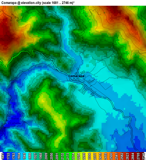
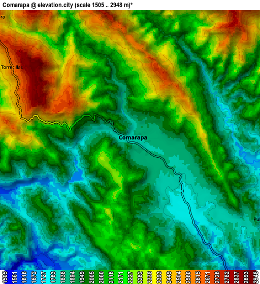
Below is the Elevation map of Comarapa, which displays elevation range with different colors. Scale of the first map is from 1681 to 2746 m (5515 to 9009 ft) with average elevation of 2023.7 meters (=6639 ft) [note 1]
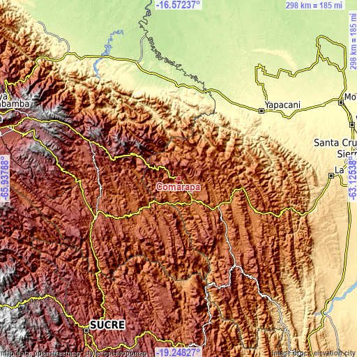
These maps also provides idea of topography and contour of this city, they are displayed at different zoom levels. More info about maps, scale and edge coordinates you can find below images.
| \ | Map #1 | Map #2 | Topo.Map |
| Scale [m] | 1681..2746 m | 1505..2948 m | × |
| Scale [ft] | 5515..9009 ft | 4938..9672 ft | × |
| Average | 2023.7 m = 6639 ft | 2083 m = 6834 ft | × |
| Width | 9.3 km = 5.8 mi | 18.6 km = 11.6 mi | 297.5 km = 184.9 mi |
| Height | 9.3 km = 5.8 mi | 18.6 km = 11.6 mi | 297.6 km = 184.9 mi |
| ↑Max Latitude | -17.873551° | -17.831721° | -16.57237° |
| Latitude at center | -17.91537° | -17.91537° | -17.91537° |
| ↓Min Latitude | -17.95718° | -17.998979° | -19.24827° |
| ← Min Longitude | -64.575575° | -64.619521° | -65.93788° |
| Longitude center | -64.53163° | -64.53163° | -64.53163° |
| →Max Longitude | -64.487685° | -64.443739° | -63.12538° |
Nearby cities:
Cities around Comarapa sort by population:
• Mizque elevation 2014 m
85.6 km,  268°
268°
• Villa Yapacaní 297 m
93.6 km,  52°
52°
• Vallegrande 2042 m
78 km,  144°
144°
• Aiquile 2258 m
75.8 km,  244°
244°
• Mairana 1326 m
64.6 km,  110°
110°
• Buena Vista 370 m
104.4 km,  60°
60°
• San Carlos 320 m
100.7 km, 55°
• Jorochito 564 m
117.7 km,  97°
97°
• San Juan del Surutú 320 m
100.3 km, 61°
• Samaipata 1647 m
75.3 km, 112°
• Los Negros 420 m
118 km,  80°
80°
• Totora 2896 m
73.1 km,  286°
286°
Multilingual:
 En español:
Comarapa elevación 1818 m.
 En France:
Comarapa élévation 1818 m.
 Auf Deutsch:
Comarapa höhe über dem Meeresspiegel ist 1818 m.

Sources and notes:
- [note 1] Map square and city borders are not equal. Map elevation data is calculated only from area inside that square.
- [src 1] Elevation data from geonames database provided with same terms of usage.
- [src 2] The elevation map of Comarapa is generated using elevation data from NASA's 3 arcsec (90m) resolution SRTM data.
- [src 3] Base (background) map © OpenStreetMap contributors tiles are generated by Geofabrik and OpenTopoMap.
Copyright & License:
This Comarapa Elevation Map is licensed under CC BY-SA. You may reuse any part from this page, if you give a proper credit by linking to this URL:
 More info on terms of use page.