Jorochito elevation
Jorochito (Santa Cruz), Bolivia elevation is 564 meters and Jorochito elevation in feet is 1850 ft above sea level [src 1]. Jorochito is a populated place (feature code) with elevation that is 1312 meters (4304 ft) smaller than average city elevation in Bolivia.
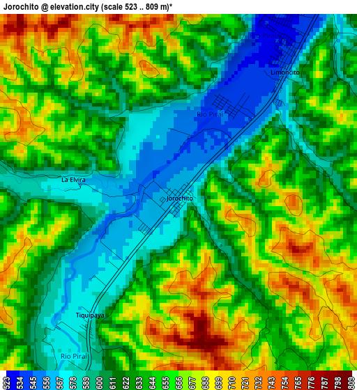
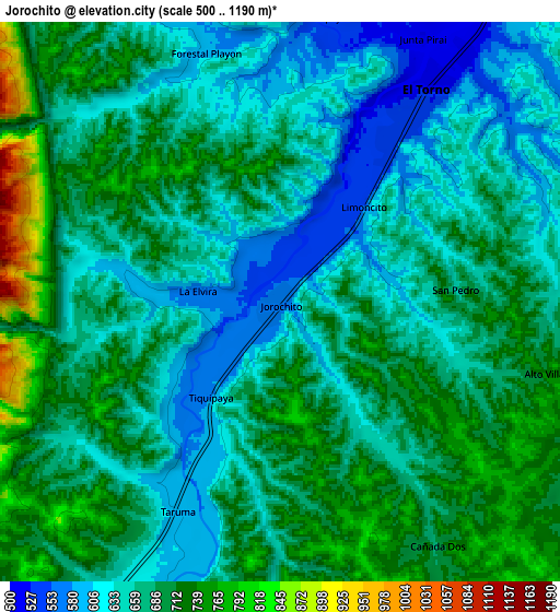
Below is the Elevation map of Jorochito, which displays elevation range with different colors. Scale of the first map is from 523 to 809 m (1716 to 2654 ft) with average elevation of 636.7 meters (=2089 ft) [note 1]
These maps also provides idea of topography and contour of this city, they are displayed at different zoom levels. More info about maps, scale and edge coordinates you can find below images.
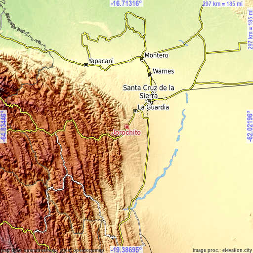
| \ | Map #1 | Map #2 | Topo.Map |
| Scale [m] | 523..809 m | 500..1190 m | × |
| Scale [ft] | 1716..2654 ft | 1640..3904 ft | × |
| Average | 636.7 m = 2089 ft | 675.5 m = 2216 ft | × |
| Width | 9.29 km = 5.8 mi | 18.58 km = 11.5 mi | 297.3 km = 184.7 mi |
| Height | 9.29 km = 5.8 mi | 18.58 km = 11.5 mi | 297.3 km = 184.7 mi |
| ↑Max Latitude | -18.013354° | -17.971557° | -16.71316° |
| Latitude at center | -18.05514° | -18.05514° | -18.05514° |
| ↓Min Latitude | -18.096916° | -18.138683° | -19.38695° |
| ← Min Longitude | -63.472155° | -63.516101° | -64.83446° |
| Longitude center | -63.42821° | -63.42821° | -63.42821° |
| →Max Longitude | -63.384265° | -63.340319° | -62.02196° |
Nearby cities:
Cities around Jorochito sort by population:
• Santa Cruz de la Sierra elevation 433 m
39.7 km,  41°
41°
• Cotoca 387 m
48 km,  56°
56°
• Santiago del Torno 514 m
9.1 km,  33°
33°
• La Bélgica 353 m
60.5 km,  21°
21°
• Mairana 1326 m
56.6 km,  262°
262°
• Limoncito 551 m
3.6 km, 42°
• Samaipata 1647 m
49.3 km,  253°
253°
• Los Negros 420 m
35.8 km,  359°
359°
• Santa Rita 593 m
12.9 km, 40°
• Paurito 361 m
52.4 km,  68°
68°
• San Julian 339 m
62.8 km, 63°
• Santa Fe 377 m
44.2 km, 68°
Multilingual:
 En español:
Jorochito elevación 564 m.
 En France:
Jorochito élévation 564 m.
 Auf Deutsch:
Jorochito höhe über dem Meeresspiegel ist 564 m.

Sources and notes:
- [note 1] Map square and city borders are not equal. Map elevation data is calculated only from area inside that square.
- [src 1] Elevation data from geonames database provided with same terms of usage.
- [src 2] The elevation map of Jorochito is generated using elevation data from NASA's 3 arcsec (90m) resolution SRTM data.
- [src 3] Base (background) map © OpenStreetMap contributors tiles are generated by Geofabrik and OpenTopoMap.
Copyright & License:
This Jorochito Elevation Map is licensed under CC BY-SA. You may reuse any part from this page, if you give a proper credit by linking to this URL:
 More info on terms of use page.