Monteagudo elevation
Monteagudo (Chuquisaca), Bolivia elevation is 1148 meters and Monteagudo elevation in feet is 3766 ft above sea level [src 1]. Monteagudo is a populated place (feature code) with elevation that is 728 meters (2388 ft) smaller than average city elevation in Bolivia.
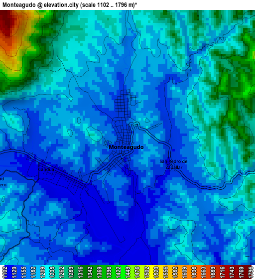
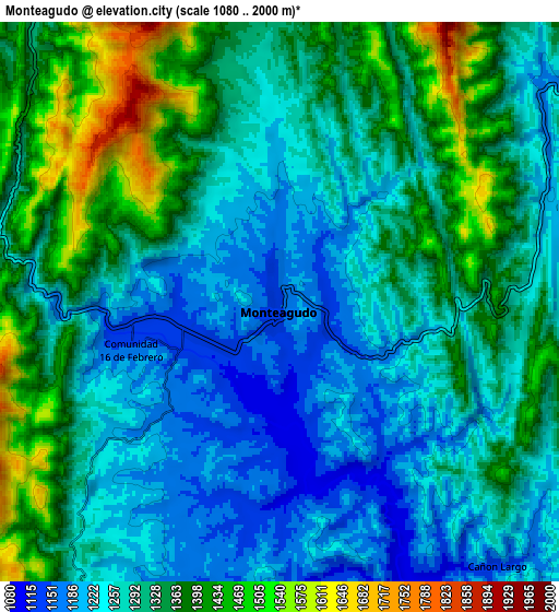
Below is the Elevation map of Monteagudo, which displays elevation range with different colors. Scale of the first map is from 1102 to 1796 m (3615 to 5892 ft) with average elevation of 1206.1 meters (=3957 ft) [note 1]
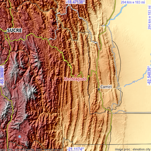
These maps also provides idea of topography and contour of this city, they are displayed at different zoom levels. More info about maps, scale and edge coordinates you can find below images.
| \ | Map #1 | Map #2 | Topo.Map |
| Scale [m] | 1102..1796 m | 1080..2000 m | × |
| Scale [ft] | 3615..5892 ft | 3543..6562 ft | × |
| Average | 1206.1 m = 3957 ft | 1309.4 m = 4296 ft | × |
| Width | 9.19 km = 5.7 mi | 18.39 km = 11.4 mi | 294.2 km = 182.8 mi |
| Height | 9.19 km = 5.7 mi | 18.39 km = 11.4 mi | 294.2 km = 182.8 mi |
| ↑Max Latitude | -19.758537° | -19.717174° | -18.47138° |
| Latitude at center | -19.79989° | -19.79989° | -19.79989° |
| ↓Min Latitude | -19.841232° | -19.882563° | -21.1174° |
| ← Min Longitude | -63.998555° | -64.042501° | -65.36086° |
| Longitude center | -63.95461° | -63.95461° | -63.95461° |
| →Max Longitude | -63.910665° | -63.866719° | -62.54836° |
Nearby cities:
Cities around Monteagudo sort by population:
• Camiri elevation 802 m
52.8 km,  120°
120°
• Vallegrande 2042 m
146.6 km,  353°
353°
• Betanzos 3329 m
159.4 km,  279°
279°
• Camargo 2412 m
160.8 km,  234°
234°
• Boyuibe 811 m
99.4 km,  135°
135°
• Charagua 799 m
79.1 km,  89°
89°
• Padilla 2091 m
65.7 km,  326°
326°
• Tarabuco 3293 m
121.9 km,  304°
304°
• Abapó 468 m
118.4 km,  30°
30°
• Villa Charcas 2954 m
141.2 km,  223°
223°
• Yamparáez 3096 m
140.1 km, 298°
• Villa Serrano 2115 m
84.4 km, 332°
Multilingual:
 En español:
Monteagudo elevación 1148 m.
 En France:
Monteagudo élévation 1148 m.
 Auf Deutsch:
Monteagudo höhe über dem Meeresspiegel ist 1148 m.

Sources and notes:
- [note 1] Map square and city borders are not equal. Map elevation data is calculated only from area inside that square.
- [src 1] Elevation data from geonames database provided with same terms of usage.
- [src 2] The elevation map of Monteagudo is generated using elevation data from NASA's 3 arcsec (90m) resolution SRTM data.
- [src 3] Base (background) map © OpenStreetMap contributors tiles are generated by Geofabrik and OpenTopoMap.
Copyright & License:
This Monteagudo Elevation Map is licensed under CC BY-SA. You may reuse any part from this page, if you give a proper credit by linking to this URL:
 More info on terms of use page.