Potosí elevation
Potosí, Bolivia elevation is 3967 meters and Potosí elevation in feet is 13015 ft above sea level [src 1]. Potosí is a seat of a first-order administrative division (feature code) with elevation that is 2091 meters (6860 ft) bigger than average city elevation in Bolivia.
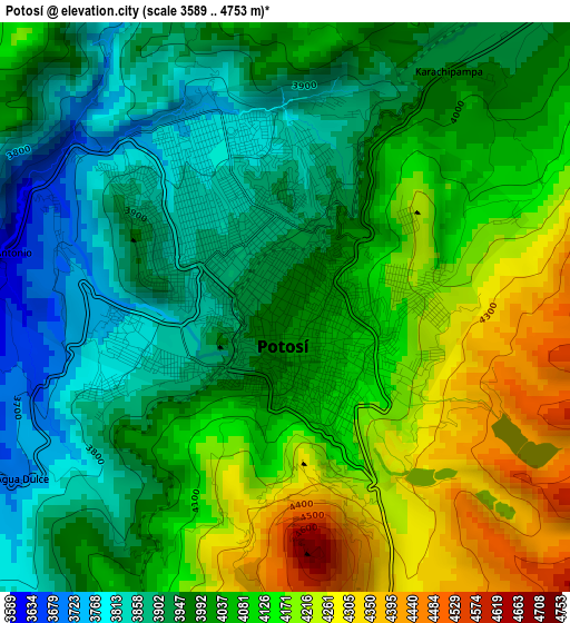
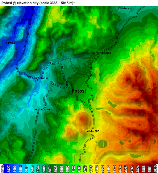
Below is the Elevation map of Potosí, which displays elevation range with different colors. Scale of the first map is from 3589 to 4753 m (11775 to 15594 ft) with average elevation of 4036.9 meters (=13244 ft) [note 1]
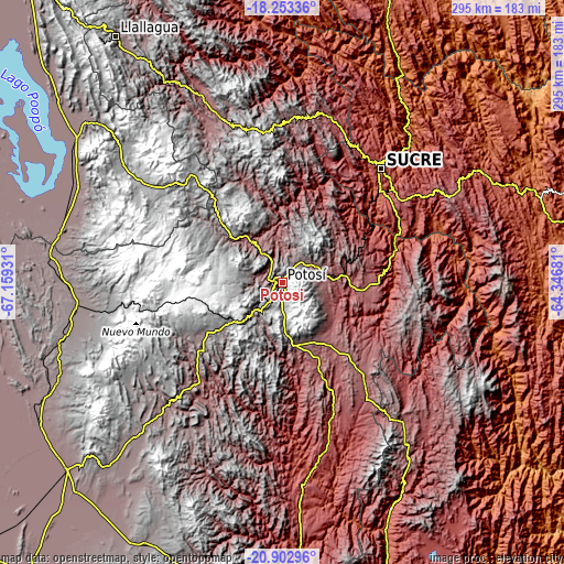
These maps also provides idea of topography and contour of this city, they are displayed at different zoom levels. More info about maps, scale and edge coordinates you can find below images.
| \ | Map #1 | Map #2 | Topo.Map |
| Scale [m] | 3589..4753 m | 3363..5015 m | × |
| Scale [ft] | 11775..15594 ft | 11033..16453 ft | × |
| Average | 4036.9 m = 13244 ft | 4088.4 m = 13413 ft | × |
| Width | 9.21 km = 5.7 mi | 18.41 km = 11.4 mi | 294.6 km = 183.1 mi |
| Height | 9.21 km = 5.7 mi | 18.41 km = 11.4 mi | 294.6 km = 183.1 mi |
| ↑Max Latitude | -19.542201° | -19.500782° | -18.25336° |
| Latitude at center | -19.58361° | -19.58361° | -19.58361° |
| ↓Min Latitude | -19.625008° | -19.666395° | -20.90296° |
| ← Min Longitude | -65.797005° | -65.840951° | -67.15931° |
| Longitude center | -65.75306° | -65.75306° | -65.75306° |
| →Max Longitude | -65.709115° | -65.665169° | -64.34681° |
Nearby cities:
Cities around Potosí sort by population:
• Sucre elevation 2798 m
79.9 km,  40°
40°
• Colchani 3668 m
146.8 km,  237°
237°
• Uyuni 3673 m
148.4 km,  228°
228°
• Challapata 3732 m
131 km,  305°
305°
• Betanzos 3329 m
31.5 km,  83°
83°
• Camargo 2412 m
130.5 km,  154°
154°
• Padilla 2091 m
155.1 km, 78°
• Santa Bárbara 4732 m
151.4 km,  191°
191°
• Tarabuco 3293 m
98.6 km,  63°
63°
• Colquechaca 4170 m
101.7 km,  344°
344°
• Villa Charcas 2954 m
155.7 km,  144°
144°
• Yamparáez 3096 m
79.3 km, 56°
Multilingual:
 En español:
Potosí elevación 3967 m.
 En France:
Potosí élévation 3967 m.


Sources and notes:
- [note 1] Map square and city borders are not equal. Map elevation data is calculated only from area inside that square.
- [src 1] Elevation data from geonames database provided with same terms of usage.
- [src 2] The elevation map of Potosí is generated using elevation data from NASA's 3 arcsec (90m) resolution SRTM data.
- [src 3] Base (background) map © OpenStreetMap contributors tiles are generated by Geofabrik and OpenTopoMap.
Copyright & License:
This Potosí Elevation Map is licensed under CC BY-SA. You may reuse any part from this page, if you give a proper credit by linking to this URL:
 More info on terms of use page.