Colchani elevation
Colchani (Potosí), Bolivia elevation is 3668 meters and Colchani elevation in feet is 12034 ft above sea level [src 1]. Colchani is a populated place (feature code) with elevation that is 1792 meters (5879 ft) bigger than average city elevation in Bolivia.
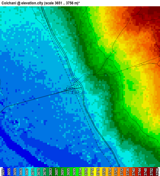
Below is the Elevation map of Colchani, which displays elevation range with different colors. Scale of the first map is from 3651 to 3756 m (11978 to 12323 ft) with average elevation of 3681.6 meters (=12079 ft) [note 1]
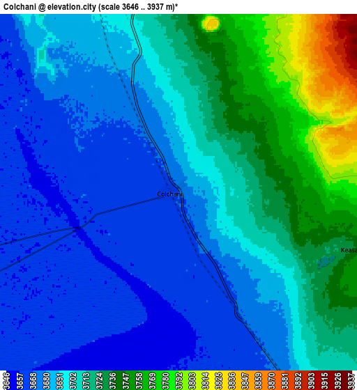
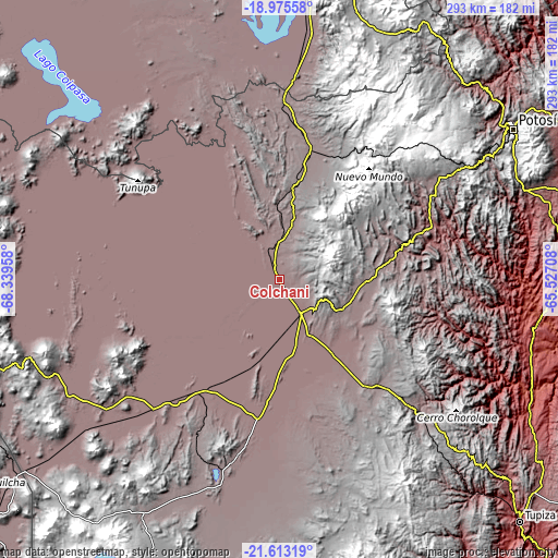
These maps also provides idea of topography and contour of this city, they are displayed at different zoom levels. More info about maps, scale and edge coordinates you can find below images.
| \ | Map #1 | Map #2 | Topo.Map |
| Scale [m] | 3651..3756 m | 3646..3937 m | × |
| Scale [ft] | 11978..12323 ft | 11962..12917 ft | × |
| Average | 3681.6 m = 12079 ft | 3701.1 m = 12143 ft | × |
| Width | 9.17 km = 5.7 mi | 18.33 km = 11.4 mi | 293.3 km = 182.2 mi |
| Height | 9.17 km = 5.7 mi | 18.33 km = 11.4 mi | 293.3 km = 182.2 mi |
| ↑Max Latitude | -20.258779° | -20.217546° | -18.97558° |
| Latitude at center | -20.3° | -20.3° | -20.3° |
| ↓Min Latitude | -20.34121° | -20.38241° | -21.61319° |
| ← Min Longitude | -66.977275° | -67.021221° | -68.33958° |
| Longitude center | -66.93333° | -66.93333° | -66.93333° |
| →Max Longitude | -66.889385° | -66.845439° | -65.52708° |
Nearby cities:
Cities around Colchani sort by population:
• Potosí elevation 3967 m
146.8 km,  57°
57°
• Llallagua 3897 m
211.8 km,  9°
9°
• Tupiza 2961 m
179.1 km,  135°
135°
• Uyuni 3673 m
21 km,  147°
147°
• Challapata 3732 m
156.4 km, 6°
• Betanzos 3329 m
175.5 km, 61°
• Camargo 2412 m
183.6 km,  101°
101°
• Santa Bárbara 4732 m
114.7 km,  126°
126°
• Atocha 3675 m
102.4 km, 133°
• Colquechaca 4170 m
202.8 km,  28°
28°
• Totoral 3900 m
200.7 km,  1°
1°
• Andamarca 3751 m
179.5 km,  340°
340°
Multilingual:
 En español:
Colchani elevación 3668 m.
 En France:
Colchani élévation 3668 m.
 Auf Deutsch:
Colchani höhe über dem Meeresspiegel ist 3668 m.

Sources and notes:
- [note 1] Map square and city borders are not equal. Map elevation data is calculated only from area inside that square.
- [src 1] Elevation data from geonames database provided with same terms of usage.
- [src 2] The elevation map of Colchani is generated using elevation data from NASA's 3 arcsec (90m) resolution SRTM data.
- [src 3] Base (background) map © OpenStreetMap contributors tiles are generated by Geofabrik and OpenTopoMap.
Copyright & License:
This Colchani Elevation Map is licensed under CC BY-SA. You may reuse any part from this page, if you give a proper credit by linking to this URL:
 More info on terms of use page.