Gŭlŭbovo elevation
Gŭlŭbovo (Stara Zagora), Bulgaria elevation is 144 meters and Gŭlŭbovo elevation in feet is 472 ft above sea level [src 1]. Gŭlŭbovo is a populated place (feature code) with elevation that is 175 meters (574 ft) smaller than average city elevation in Bulgaria.
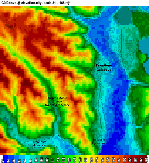
Below is the Elevation map of Gŭlŭbovo, which displays elevation range with different colors. Scale of the first map is from 81 to 168 m (266 to 551 ft) with average elevation of 120.2 meters (=394 ft) [note 1]
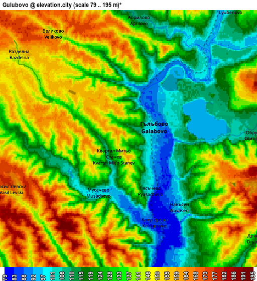
These maps also provides idea of topography and contour of this city, they are displayed at different zoom levels. More info about maps, scale and edge coordinates you can find below images.
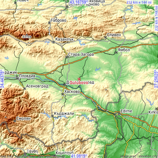
| \ | Map #1 | Map #2 | Topo.Map |
| Scale [m] | 81..168 m | 79..195 m | × |
| Scale [ft] | 266..551 ft | 259..640 ft | × |
| Average | 120.2 m = 394 ft | 134 m = 440 ft | × |
| Width | 7.25 km = 4.5 mi | 14.49 km = 9 mi | 231.9 km = 144.1 mi |
| Height | 7.25 km = 4.5 mi | 14.49 km = 9 mi | 231.9 km = 144.1 mi |
| ↑Max Latitude | 42.165911° | 42.198475° | 43.16759° |
| Latitude at center | 42.13333° | 42.13333° | 42.13333° |
| ↓Min Latitude | 42.100732° | 42.068118° | 41.0819° |
| ← Min Longitude | 25.806055° | 25.762109° | 24.44375° |
| Longitude center | 25.85° | 25.85° | 25.85° |
| →Max Longitude | 25.893945° | 25.937891° | 27.25625° |
Nearby cities:
Cities around Gŭlŭbovo sort by population:
• Stara Zagora elevation 205 m
37.4 km,  332°
332°
• Haskovo 195 m
32.9 km,  227°
227°
• Dimitrovgrad 111 m
22.6 km,  245°
245°
• Nova Zagora 130 m
41.3 km,  19°
19°
• Harmanli 74 m
22.6 km,  169°
169°
• Chirpan 195 m
43.2 km,  279°
279°
• Radnevo 116 m
19.8 km, 20°
• Lyubimets 68 m
38.5 km,  149°
149°
• Simeonovgrad 104 m
11.2 km,  187°
187°
• Topolovgrad 328 m
40.3 km,  97°
97°
• Mineralni Bani 342 m
47.8 km,  239°
239°
• Elkhovo 359 m
44.1 km,  309°
309°
Multilingual:
 En español:
Gŭlŭbovo elevación 144 m.
 En France:
Gŭlŭbovo élévation 144 m.
 Auf Deutsch:
Gŭlŭbovo höhe über dem Meeresspiegel ist 144 m.

Sources and notes:
- [note 1] Map square and city borders are not equal. Map elevation data is calculated only from area inside that square.
- [src 1] Elevation data from geonames database provided with same terms of usage.
- [src 2] The elevation map of Gŭlŭbovo is generated using elevation data from NASA's 3 arcsec (90m) resolution SRTM data.
- [src 3] Base (background) map © OpenStreetMap contributors tiles are generated by Geofabrik and OpenTopoMap.
Copyright & License:
This Gŭlŭbovo Elevation Map is licensed under CC BY-SA. You may reuse any part from this page, if you give a proper credit by linking to this URL:
 More info on terms of use page.