Harmanli elevation
Harmanli (Haskovo, Obshtina Harmanli), Bulgaria elevation is 74 meters and Harmanli elevation in feet is 243 ft above sea level [src 1]. Harmanli is a populated place (feature code) with elevation that is 245 meters (804 ft) smaller than average city elevation in Bulgaria.
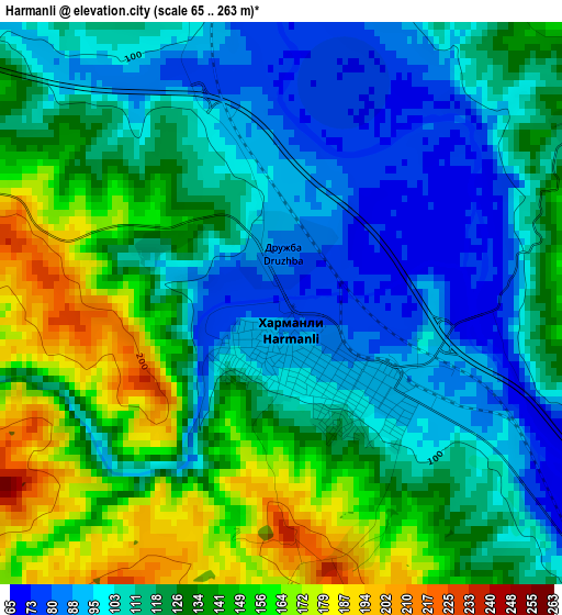
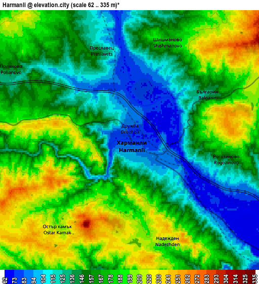
Below is the Elevation map of Harmanli, which displays elevation range with different colors. Scale of the first map is from 65 to 263 m (213 to 863 ft) with average elevation of 122.8 meters (=403 ft) [note 1]
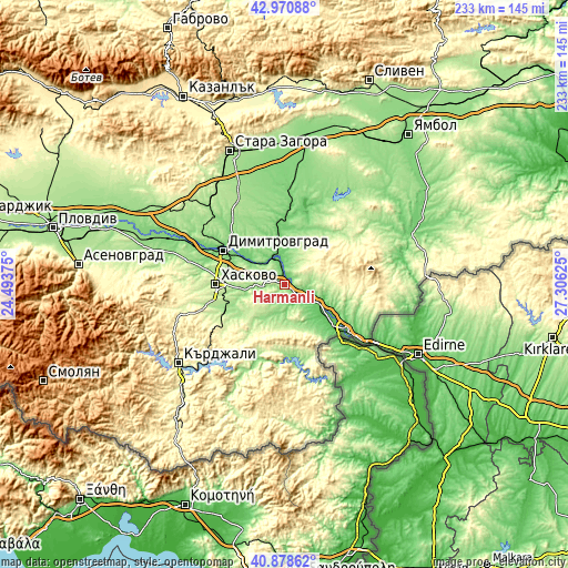
These maps also provides idea of topography and contour of this city, they are displayed at different zoom levels. More info about maps, scale and edge coordinates you can find below images.
| \ | Map #1 | Map #2 | Topo.Map |
| Scale [m] | 65..263 m | 62..335 m | × |
| Scale [ft] | 213..863 ft | 203..1099 ft | × |
| Average | 122.8 m = 403 ft | 163.3 m = 536 ft | × |
| Width | 7.27 km = 4.5 mi | 14.54 km = 9 mi | 232.6 km = 144.5 mi |
| Height | 7.27 km = 4.5 mi | 14.54 km = 9 mi | 232.6 km = 144.5 mi |
| ↑Max Latitude | 41.966014° | 41.99868° | 42.97088° |
| Latitude at center | 41.93333° | 41.93333° | 41.93333° |
| ↓Min Latitude | 41.90063° | 41.867913° | 40.87862° |
| ← Min Longitude | 25.856055° | 25.812109° | 24.49375° |
| Longitude center | 25.9° | 25.9° | 25.9° |
| →Max Longitude | 25.943945° | 25.987891° | 27.30625° |
Nearby cities:
Cities around Harmanli sort by population:
• Haskovo elevation 195 m
28.5 km,  270°
270°
• Kardzhali 278 m
54.3 km,  234°
234°
• Dimitrovgrad 111 m
28 km,  297°
297°
• Svilengrad 58 m
31 km,  126°
126°
• Radnevo 116 m
40.9 km,  3°
3°
• Gŭlŭbovo 144 m
22.6 km,  349°
349°
• Lyubimets 68 m
18.8 km, 126°
• Simeonovgrad 104 m
12.4 km,  333°
333°
• Topolovgrad 328 m
39.5 km,  65°
65°
• Ivaylovgrad 178 m
48.9 km,  157°
157°
• Mineralni Bani 342 m
45.5 km, 267°
• Madzharovo 171 m
33.3 km,  185°
185°
Multilingual:
 En español:
Harmanli elevación 74 m.
 En France:
Harmanli élévation 74 m.


Sources and notes:
- [note 1] Map square and city borders are not equal. Map elevation data is calculated only from area inside that square.
- [src 1] Elevation data from geonames database provided with same terms of usage.
- [src 2] The elevation map of Harmanli is generated using elevation data from NASA's 3 arcsec (90m) resolution SRTM data.
- [src 3] Base (background) map © OpenStreetMap contributors tiles are generated by Geofabrik and OpenTopoMap.
Copyright & License:
This Harmanli Elevation Map is licensed under CC BY-SA. You may reuse any part from this page, if you give a proper credit by linking to this URL:
 More info on terms of use page.