Chirpan elevation
Chirpan (Stara Zagora, Obshtina Chirpan), Bulgaria elevation is 195 meters and Chirpan elevation in feet is 640 ft above sea level [src 1]. Chirpan is a populated place (feature code) with elevation that is 124 meters (407 ft) smaller than average city elevation in Bulgaria.
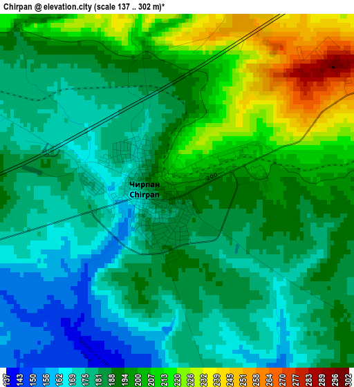
Below is the Elevation map of Chirpan, which displays elevation range with different colors. Scale of the first map is from 137 to 302 m (449 to 991 ft) with average elevation of 190.2 meters (=624 ft) [note 1]
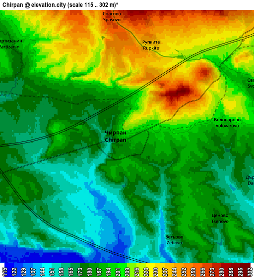
These maps also provides idea of topography and contour of this city, they are displayed at different zoom levels. More info about maps, scale and edge coordinates you can find below images.
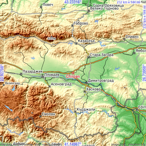
| \ | Map #1 | Map #2 | Topo.Map |
| Scale [m] | 137..302 m | 115..302 m | × |
| Scale [ft] | 449..991 ft | 377..991 ft | × |
| Average | 190.2 m = 624 ft | 190.9 m = 626 ft | × |
| Width | 7.24 km = 4.5 mi | 14.48 km = 9 mi | 231.7 km = 144 mi |
| Height | 7.24 km = 4.5 mi | 14.48 km = 9 mi | 231.7 km = 144 mi |
| ↑Max Latitude | 42.232547° | 42.265076° | 43.23316° |
| Latitude at center | 42.2° | 42.2° | 42.2° |
| ↓Min Latitude | 42.167437° | 42.134857° | 41.14967° |
| ← Min Longitude | 25.289385° | 25.245439° | 23.92708° |
| Longitude center | 25.33333° | 25.33333° | 25.33333° |
| →Max Longitude | 25.377275° | 25.421221° | 26.73958° |
Nearby cities:
Cities around Chirpan sort by population:
• Stara Zagora elevation 205 m
36.2 km,  44°
44°
• Haskovo 195 m
34.8 km,  148°
148°
• Dimitrovgrad 111 m
27.6 km,  127°
127°
• Parvomay 134 m
14.7 km,  220°
220°
• Rakovski 162 m
33.3 km,  284°
284°
• Gŭlŭbovo 144 m
43.2 km,  99°
99°
• Sadovo 153 m
33.3 km,  256°
256°
• Topolovo 471 m
43.2 km, 219°
• Brezovo 249 m
26.5 km,  309°
309°
• Mineralni Bani 342 m
31.5 km,  177°
177°
• Zelenikovo 305 m
30.3 km,  317°
317°
• Elkhovo 359 m
22 km,  21°
21°
Multilingual:
 En español:
Chirpan elevación 195 m.
 En France:
Chirpan élévation 195 m.


Sources and notes:
- [note 1] Map square and city borders are not equal. Map elevation data is calculated only from area inside that square.
- [src 1] Elevation data from geonames database provided with same terms of usage.
- [src 2] The elevation map of Chirpan is generated using elevation data from NASA's 3 arcsec (90m) resolution SRTM data.
- [src 3] Base (background) map © OpenStreetMap contributors tiles are generated by Geofabrik and OpenTopoMap.
Copyright & License:
This Chirpan Elevation Map is licensed under CC BY-SA. You may reuse any part from this page, if you give a proper credit by linking to this URL:
 More info on terms of use page.