Sevlievo elevation
Sevlievo (Gabrovo, Obshtina Sevlievo), Bulgaria elevation is 195 meters and Sevlievo elevation in feet is 640 ft above sea level [src 1]. Sevlievo is a populated place (feature code) with elevation that is 124 meters (407 ft) smaller than average city elevation in Bulgaria.
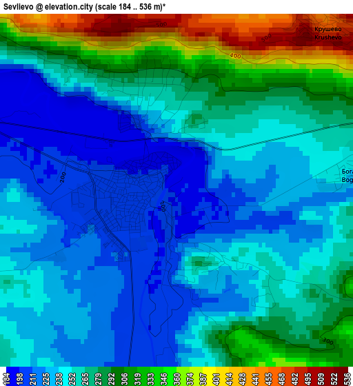
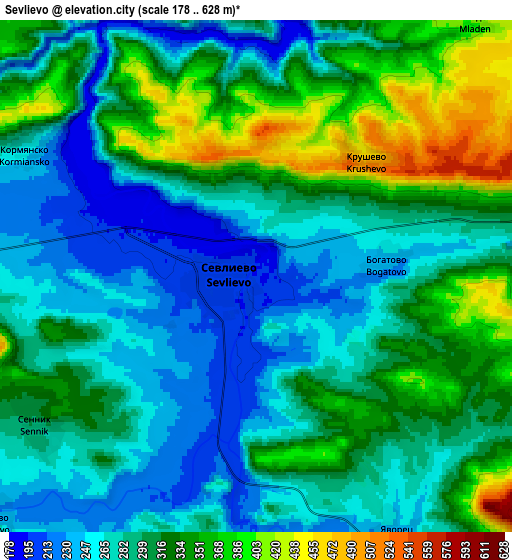
Below is the Elevation map of Sevlievo, which displays elevation range with different colors. Scale of the first map is from 184 to 536 m (604 to 1759 ft) with average elevation of 262.9 meters (=863 ft) [note 1]
These maps also provides idea of topography and contour of this city, they are displayed at different zoom levels. More info about maps, scale and edge coordinates you can find below images.
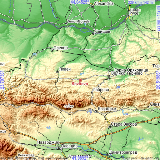
| \ | Map #1 | Map #2 | Topo.Map |
| Scale [m] | 184..536 m | 178..628 m | × |
| Scale [ft] | 604..1759 ft | 584..2060 ft | × |
| Average | 262.9 m = 863 ft | 302.5 m = 992 ft | × |
| Width | 7.14 km = 4.4 mi | 14.29 km = 8.9 mi | 228.6 km = 142 mi |
| Height | 7.14 km = 4.4 mi | 14.29 km = 8.9 mi | 228.6 km = 142 mi |
| ↑Max Latitude | 43.057948° | 43.090048° | 44.04525° |
| Latitude at center | 43.02583° | 43.02583° | 43.02583° |
| ↓Min Latitude | 42.993696° | 42.961544° | 41.9892° |
| ← Min Longitude | 25.069665° | 25.025719° | 23.70736° |
| Longitude center | 25.11361° | 25.11361° | 25.11361° |
| →Max Longitude | 25.157555° | 25.201501° | 26.51986° |
Nearby cities:
Cities around Sevlievo sort by population:
• Gabrovo elevation 538 m
24.6 km,  133°
133°
• Lovech 179 m
34.4 km,  290°
290°
• Troyan 389 m
35.5 km,  245°
245°
• Tryavna 488 m
36.1 km,  119°
119°
• Pavlikeni 157 m
29.5 km,  35°
35°
• Levski 73 m
37.9 km,  2°
2°
• Dryanovo 256 m
30.1 km,  99°
99°
• Apriltsi 511 m
26 km,  217°
217°
• Letnitsa 72 m
31.9 km,  354°
354°
• Byala Cherkva 105 m
24.6 km, 37°
• Suhindol 269 m
19.2 km,  16°
16°
• Shipka 692 m
38.8 km,  152°
152°
Multilingual:
 En español:
Sevlievo elevación 195 m.
 En France:
Sevlievo élévation 195 m.
 Auf Deutsch:
Sevlievo höhe über dem Meeresspiegel ist 195 m.

Sources and notes:
- [note 1] Map square and city borders are not equal. Map elevation data is calculated only from area inside that square.
- [src 1] Elevation data from geonames database provided with same terms of usage.
- [src 2] The elevation map of Sevlievo is generated using elevation data from NASA's 3 arcsec (90m) resolution SRTM data.
- [src 3] Base (background) map © OpenStreetMap contributors tiles are generated by Geofabrik and OpenTopoMap.
Copyright & License:
This Sevlievo Elevation Map is licensed under CC BY-SA. You may reuse any part from this page, if you give a proper credit by linking to this URL:
 More info on terms of use page.