Troyan elevation
Troyan (Lovech, Obshtina Troyan), Bulgaria elevation is 389 meters and Troyan elevation in feet is 1276 ft above sea level [src 1]. Troyan is a populated place (feature code) with elevation that is 70 meters (230 ft) bigger than average city elevation in Bulgaria.
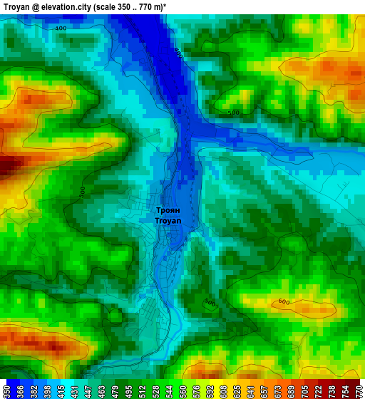
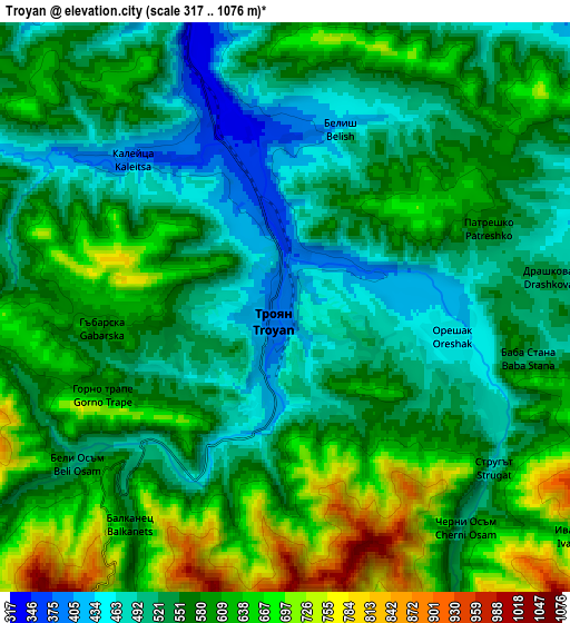
Below is the Elevation map of Troyan, which displays elevation range with different colors. Scale of the first map is from 350 to 770 m (1148 to 2526 ft) with average elevation of 496.9 meters (=1630 ft) [note 1]
These maps also provides idea of topography and contour of this city, they are displayed at different zoom levels. More info about maps, scale and edge coordinates you can find below images.
| \ | Map #1 | Map #2 | Topo.Map |
| Scale [m] | 350..770 m | 317..1076 m | × |
| Scale [ft] | 1148..2526 ft | 1040..3530 ft | × |
| Average | 496.9 m = 1630 ft | 573 m = 1880 ft | × |
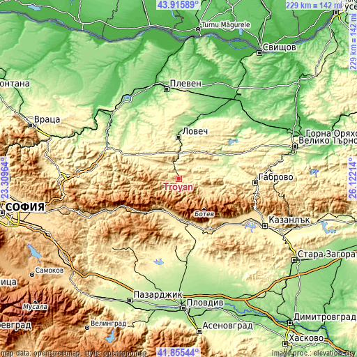
| Width | 7.16 km = 4.4 mi | 14.32 km = 8.9 mi | 229.1 km = 142.4 mi |
| Height | 7.16 km = 4.4 mi | 14.32 km = 8.9 mi | 229.1 km = 142.4 mi |
| ↑Max Latitude | 42.926456° | 42.958626° | 43.91589° |
| Latitude at center | 42.89427° | 42.89427° | 42.89427° |
| ↓Min Latitude | 42.862067° | 42.829847° | 41.85544° |
| ← Min Longitude | 24.671945° | 24.627999° | 23.30964° |
| Longitude center | 24.71589° | 24.71589° | 24.71589° |
| →Max Longitude | 24.759835° | 24.803781° | 26.12214° |
Nearby cities:
Cities around Troyan sort by population:
• Lovech elevation 179 m
26.6 km,  0°
0°
• Sevlievo 195 m
35.5 km,  65°
65°
• Karlovo 406 m
29.8 km,  166°
166°
• Teteven 419 m
36.7 km,  273°
273°
• Hisarya 364 m
43.9 km,  181°
181°
• Apriltsi 511 m
17.5 km,  109°
109°
• Kalofer 731 m
37.8 km,  144°
144°
• Ugarchin 267 m
33.4 km,  313°
313°
• Koprivshtitsa 1098 m
41.6 km,  225°
225°
• Anton 1174 m
38.8 km,  245°
245°
• Klisura 772 m
30.6 km, 225°
• Asen 470 m
47.9 km,  124°
124°
Multilingual:
 En español:
Troyan elevación 389 m.
 En France:
Troyan élévation 389 m.


Sources and notes:
- [note 1] Map square and city borders are not equal. Map elevation data is calculated only from area inside that square.
- [src 1] Elevation data from geonames database provided with same terms of usage.
- [src 2] The elevation map of Troyan is generated using elevation data from NASA's 3 arcsec (90m) resolution SRTM data.
- [src 3] Base (background) map © OpenStreetMap contributors tiles are generated by Geofabrik and OpenTopoMap.
Copyright & License:
This Troyan Elevation Map is licensed under CC BY-SA. You may reuse any part from this page, if you give a proper credit by linking to this URL:
 More info on terms of use page.