Pavlikeni elevation
Pavlikeni (Veliko Tarnovo, Obshtina Pavlikeni), Bulgaria elevation is 157 meters and Pavlikeni elevation in feet is 515 ft above sea level [src 1]. Pavlikeni is a populated place (feature code) with elevation that is 162 meters (531 ft) smaller than average city elevation in Bulgaria.
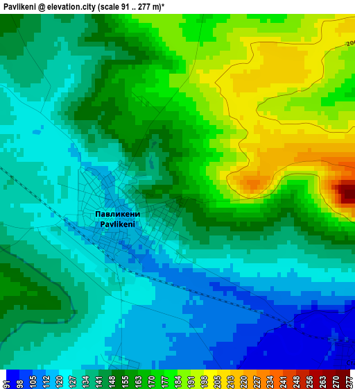
Below is the Elevation map of Pavlikeni, which displays elevation range with different colors. Scale of the first map is from 91 to 277 m (299 to 909 ft) with average elevation of 148.7 meters (=488 ft) [note 1]
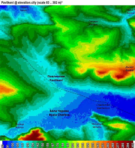
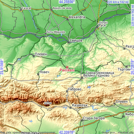
These maps also provides idea of topography and contour of this city, they are displayed at different zoom levels. More info about maps, scale and edge coordinates you can find below images.
| \ | Map #1 | Map #2 | Topo.Map |
| Scale [m] | 91..277 m | 83..302 m | × |
| Scale [ft] | 299..909 ft | 272..991 ft | × |
| Average | 148.7 m = 488 ft | 150.1 m = 492 ft | × |
| Width | 7.12 km = 4.4 mi | 14.24 km = 8.8 mi | 227.8 km = 141.5 mi |
| Height | 7.12 km = 4.4 mi | 14.24 km = 8.8 mi | 227.8 km = 141.5 mi |
| ↑Max Latitude | 43.274784° | 43.306771° | 44.25856° |
| Latitude at center | 43.24278° | 43.24278° | 43.24278° |
| ↓Min Latitude | 43.210759° | 43.178722° | 42.20978° |
| ← Min Longitude | 25.277995° | 25.234049° | 23.91569° |
| Longitude center | 25.32194° | 25.32194° | 25.32194° |
| →Max Longitude | 25.365885° | 25.409831° | 26.72819° |
Nearby cities:
Cities around Pavlikeni sort by population:
• Veliko Tŭrnovo elevation 207 m
30.7 km,  125°
125°
• Gorna Oryahovitsa 146 m
33.3 km,  112°
112°
• Sevlievo 195 m
29.5 km,  215°
215°
• Levski 73 m
20.6 km,  312°
312°
• Lyaskovets 174 m
36.1 km, 113°
• Dryanovo 256 m
32 km,  156°
156°
• Polski Trambesh 30 m
29.2 km,  60°
60°
• Debelets 158 m
33.4 km, 134°
• Letnitsa 72 m
21.5 km,  290°
290°
• Byala Cherkva 105 m
5.1 km,  200°
200°
• Parvomaytsi 94 m
28.5 km, 111°
• Suhindol 269 m
12.7 km,  243°
243°
Multilingual:
 En español:
Pavlikeni elevación 157 m.
 En France:
Pavlikeni élévation 157 m.
 Auf Deutsch:
Pavlikeni höhe über dem Meeresspiegel ist 157 m.

Sources and notes:
- [note 1] Map square and city borders are not equal. Map elevation data is calculated only from area inside that square.
- [src 1] Elevation data from geonames database provided with same terms of usage.
- [src 2] The elevation map of Pavlikeni is generated using elevation data from NASA's 3 arcsec (90m) resolution SRTM data.
- [src 3] Base (background) map © OpenStreetMap contributors tiles are generated by Geofabrik and OpenTopoMap.
Copyright & License:
This Pavlikeni Elevation Map is licensed under CC BY-SA. You may reuse any part from this page, if you give a proper credit by linking to this URL:
 More info on terms of use page.