Silistra elevation
Silistra, Bulgaria elevation is 4 meters and Silistra elevation in feet is 13 ft above sea level [src 1]. Silistra is a seat of a first-order administrative division (feature code) with elevation that is 315 meters (1033 ft) smaller than average city elevation in Bulgaria.
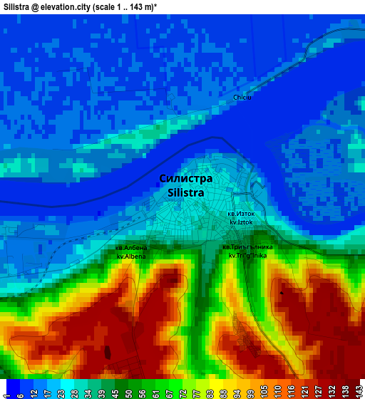
Below is the Elevation map of Silistra, which displays elevation range with different colors. Scale of the first map is from 1 to 143 m (3 to 469 ft) with average elevation of 42.7 meters (=140 ft) [note 1]
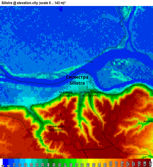
These maps also provides idea of topography and contour of this city, they are displayed at different zoom levels. More info about maps, scale and edge coordinates you can find below images.
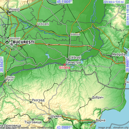
| \ | Map #1 | Map #2 | Topo.Map |
| Scale [m] | 1..143 m | 0..143 m | × |
| Scale [ft] | 3..469 ft | 0..469 ft | × |
| Average | 42.7 m = 140 ft | 52.4 m = 172 ft | × |
| Width | 7.02 km = 4.4 mi | 14.03 km = 8.7 mi | 224.5 km = 139.5 mi |
| Height | 7.02 km = 4.4 mi | 14.03 km = 8.7 mi | 224.5 km = 139.5 mi |
| ↑Max Latitude | 44.148641° | 44.180165° | 45.11805° |
| Latitude at center | 44.1171° | 44.1171° | 44.1171° |
| ↓Min Latitude | 44.085542° | 44.053968° | 43.09891° |
| ← Min Longitude | 27.216615° | 27.172669° | 25.85431° |
| Longitude center | 27.26056° | 27.26056° | 27.26056° |
| →Max Longitude | 27.304505° | 27.348451° | 28.66681° |
Nearby cities:
Cities around Silistra sort by population:
• Tutrakan elevation 109 m
52.3 km,  261°
261°
• Isperih 279 m
56.2 km,  217°
217°
• Tervel 266 m
42.7 km,  163°
163°
• Dulovo 226 m
34.6 km,  194°
194°
• Zavet 240 m
61.1 km,  229°
229°
• Glavinitsa 108 m
40.8 km,  236°
236°
• Alfatar 189 m
19.2 km,  173°
173°
• Krushari 198 m
51.8 km,  130°
130°
• Kaolinovo 266 m
56.8 km, 191°
• Venets 349 m
68.3 km,  202°
202°
• Sitovo 116 m
21.7 km, 242°
• Kaynardzha 102 m
24.1 km, 125°
Multilingual:
 En español:
Silistra elevación 4 m.
 En France:
Silistra élévation 4 m.


Sources and notes:
- [note 1] Map square and city borders are not equal. Map elevation data is calculated only from area inside that square.
- [src 1] Elevation data from geonames database provided with same terms of usage.
- [src 2] The elevation map of Silistra is generated using elevation data from NASA's 3 arcsec (90m) resolution SRTM data.
- [src 3] Base (background) map © OpenStreetMap contributors tiles are generated by Geofabrik and OpenTopoMap.
Copyright & License:
This Silistra Elevation Map is licensed under CC BY-SA. You may reuse any part from this page, if you give a proper credit by linking to this URL:
 More info on terms of use page.