Kaynardzha elevation
Kaynardzha (Silistra, Obshtina Kaynardzha), Bulgaria elevation is 102 meters and Kaynardzha elevation in feet is 335 ft above sea level [src 1]. Kaynardzha is a seat of a second-order administrative division (feature code) with elevation that is 217 meters (712 ft) smaller than average city elevation in Bulgaria.
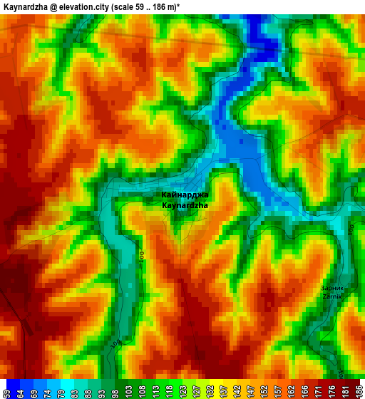
Below is the Elevation map of Kaynardzha, which displays elevation range with different colors. Scale of the first map is from 59 to 186 m (194 to 610 ft) with average elevation of 135 meters (=443 ft) [note 1]
These maps also provides idea of topography and contour of this city, they are displayed at different zoom levels. More info about maps, scale and edge coordinates you can find below images.
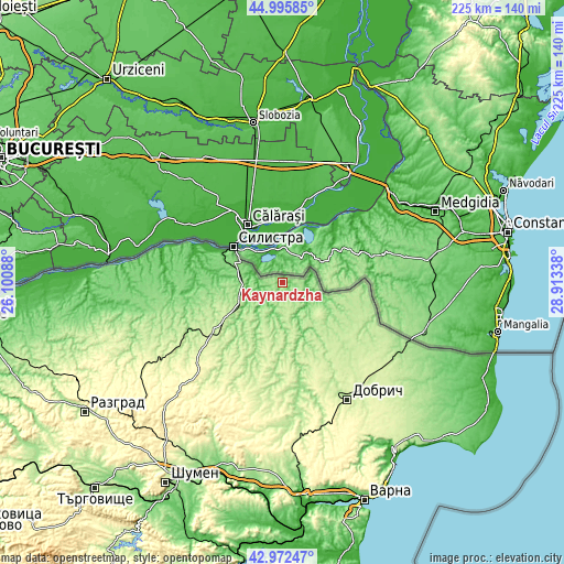
| \ | Map #1 | Topo.Map |
| Scale [m] | 59..186 m | × |
| Scale [ft] | 194..610 ft | × |
| Average | 135 m = 443 ft | × |
| Width | 7.03 km = 4.4 mi | 225 km = 139.8 mi |
| Height | 7.03 km = 4.4 mi | 225 km = 139.8 mi |
| ↑Max Latitude | 44.024387° | 44.99585° |
| Latitude at center | 43.99278° | 43.99278° |
| ↓Min Latitude | 43.961156° | 42.97247° |
| ← Min Longitude | 27.463185° | 26.10088° |
| Longitude center | 27.50713° | 27.50713° |
| →Max Longitude | 27.551075° | 28.91338° |
Nearby cities:
Cities around Kaynardzha sort by population:
• Dobrich elevation 214 m
54.1 km,  151°
151°
• Silistra 4 m
24.1 km,  305°
305°
• Isperih 279 m
62.1 km,  240°
240°
• General Toshevo 228 m
53.5 km,  127°
127°
• Tervel 266 m
28.3 km,  196°
196°
• Dulovo 226 m
34.7 km, 235°
• Valchidol 265 m
66 km,  177°
177°
• Glavinitsa 108 m
54.6 km,  261°
261°
• Alfatar 189 m
18.4 km,  253°
253°
• Krushari 198 m
27.9 km, 134°
• Kaolinovo 266 m
52.3 km,  216°
216°
• Sitovo 116 m
39.2 km,  275°
275°
Multilingual:
 En español:
Kaynardzha elevación 102 m.
 En France:
Kaynardzha élévation 102 m.
 Auf Deutsch:
Kaynardzha höhe über dem Meeresspiegel ist 102 m.

Sources and notes:
- [note 1] Map square and city borders are not equal. Map elevation data is calculated only from area inside that square.
- [src 1] Elevation data from geonames database provided with same terms of usage.
- [src 2] The elevation map of Kaynardzha is generated using elevation data from NASA's 3 arcsec (90m) resolution SRTM data.
- [src 3] Base (background) map © OpenStreetMap contributors tiles are generated by Geofabrik and OpenTopoMap.
Copyright & License:
This Kaynardzha Elevation Map is licensed under CC BY-SA. You may reuse any part from this page, if you give a proper credit by linking to this URL:
 More info on terms of use page.