Svishtov elevation
Svishtov (Veliko Tarnovo, Obshtina Svishtov), Bulgaria elevation is 1 meters and Svishtov elevation in feet is 3 ft above sea level [src 1]. Svishtov is a populated place (feature code) with elevation that is 318 meters (1043 ft) smaller than average city elevation in Bulgaria.
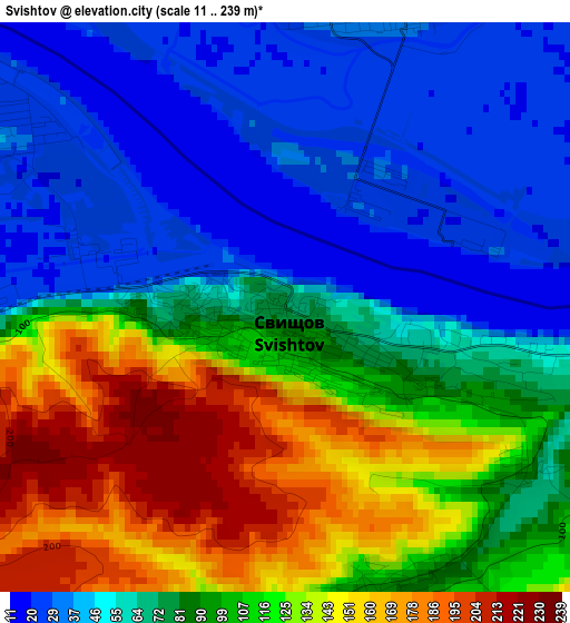
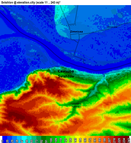
Below is the Elevation map of Svishtov, which displays elevation range with different colors. Scale of the first map is from 11 to 239 m (36 to 784 ft) with average elevation of 86.3 meters (=283 ft) [note 1]
These maps also provides idea of topography and contour of this city, they are displayed at different zoom levels. More info about maps, scale and edge coordinates you can find below images.
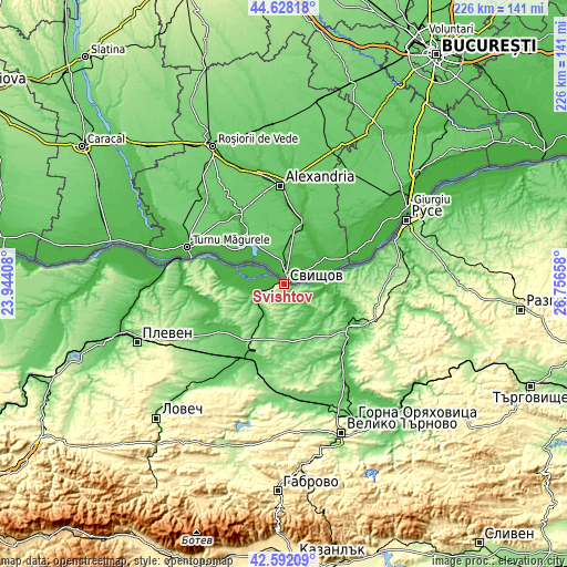
| \ | Map #1 | Map #2 | Topo.Map |
| Scale [m] | 11..239 m | 11..243 m | × |
| Scale [ft] | 36..784 ft | 36..797 ft | × |
| Average | 86.3 m = 283 ft | 88.6 m = 291 ft | × |
| Width | 7.07 km = 4.4 mi | 14.15 km = 8.8 mi | 226.4 km = 140.7 mi |
| Height | 7.07 km = 4.4 mi | 14.15 km = 8.8 mi | 226.4 km = 140.7 mi |
| ↑Max Latitude | 43.650556° | 43.682344° | 44.62818° |
| Latitude at center | 43.61875° | 43.61875° | 43.61875° |
| ↓Min Latitude | 43.586928° | 43.555088° | 42.59209° |
| ← Min Longitude | 25.306385° | 25.262439° | 23.94408° |
| Longitude center | 25.35033° | 25.35033° | 25.35033° |
| →Max Longitude | 25.394275° | 25.438221° | 26.75658° |
Nearby cities:
Cities around Svishtov sort by population:
• Pavlikeni elevation 157 m
41.9 km,  183°
183°
• Levski 73 m
33 km,  211°
211°
• Belene 29 m
18.3 km,  279°
279°
• Polski Trambesh 30 m
35.8 km,  140°
140°
• Slavyanovo 135 m
42.5 km,  246°
246°
• Dve Mogili 238 m
42.3 km,  93°
93°
• Nikopol 108 m
37.9 km, 284°
• Letnitsa 72 m
40.8 km, 213°
• Byala Cherkva 105 m
46.7 km, 184°
• Borovo 286 m
39.3 km,  109°
109°
• Pordim 182 m
48.1 km,  237°
237°
• Tsenovo 46 m
26.4 km, 110°
Multilingual:
 En español:
Svishtov elevación 1 m.
 En France:
Svishtov élévation 1 m.


Sources and notes:
- [note 1] Map square and city borders are not equal. Map elevation data is calculated only from area inside that square.
- [src 1] Elevation data from geonames database provided with same terms of usage.
- [src 2] The elevation map of Svishtov is generated using elevation data from NASA's 3 arcsec (90m) resolution SRTM data.
- [src 3] Base (background) map © OpenStreetMap contributors tiles are generated by Geofabrik and OpenTopoMap.
Copyright & License:
This Svishtov Elevation Map is licensed under CC BY-SA. You may reuse any part from this page, if you give a proper credit by linking to this URL:
 More info on terms of use page.