Tsenovo elevation
Tsenovo (Ruse, Obshtina Tsenovo), Bulgaria elevation is 46 meters and Tsenovo elevation in feet is 151 ft above sea level [src 1]. Tsenovo is a seat of a second-order administrative division (feature code) with elevation that is 273 meters (896 ft) smaller than average city elevation in Bulgaria.
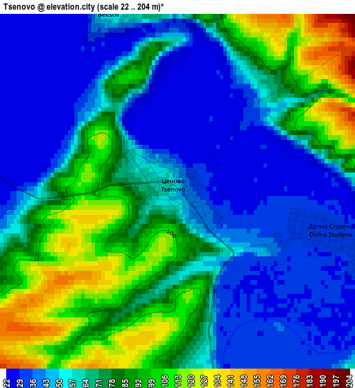
Below is the Elevation map of Tsenovo, which displays elevation range with different colors. Scale of the first map is from 22 to 204 m (72 to 669 ft) with average elevation of 65.6 meters (=215 ft) [note 1]
These maps also provides idea of topography and contour of this city, they are displayed at different zoom levels. More info about maps, scale and edge coordinates you can find below images.
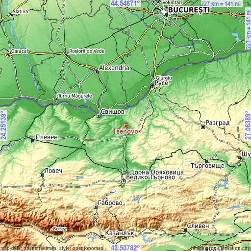
| \ | Map #1 | Topo.Map |
| Scale [m] | 22..204 m | × |
| Scale [ft] | 72..669 ft | × |
| Average | 65.6 m = 215 ft | × |
| Width | 7.08 km = 4.4 mi | 226.7 km = 140.9 mi |
| Height | 7.08 km = 4.4 mi | 226.7 km = 140.9 mi |
| ↑Max Latitude | 43.567729° | 44.54671° |
| Latitude at center | 43.53588° | 43.53588° |
| ↓Min Latitude | 43.504014° | 42.50782° |
| ← Min Longitude | 25.613695° | 24.25139° |
| Longitude center | 25.65764° | 25.65764° |
| →Max Longitude | 25.701585° | 27.06389° |
Nearby cities:
Cities around Tsenovo sort by population:
• Ruse elevation 26 m
42.1 km,  34°
34°
• Gorna Oryahovitsa 146 m
45.5 km,  175°
175°
• Svishtov 1 m
26.4 km,  290°
290°
• Pavlikeni 157 m
42.4 km,  219°
219°
• Belene 29 m
44.5 km, 285°
• Strazhitsa 107 m
41.9 km,  143°
143°
• Polski Trambesh 30 m
18.3 km,  185°
185°
• Dve Mogili 238 m
18.6 km,  70°
70°
• Opaka 224 m
42.2 km,  103°
103°
• Parvomaytsi 94 m
42.9 km, 180°
• Borovo 286 m
12.9 km,  107°
107°
• Ivanovo 180 m
29.2 km,  55°
55°
Multilingual:
 En español:
Tsenovo elevación 46 m.
 En France:
Tsenovo élévation 46 m.


Sources and notes:
- [note 1] Map square and city borders are not equal. Map elevation data is calculated only from area inside that square.
- [src 1] Elevation data from geonames database provided with same terms of usage.
- [src 2] The elevation map of Tsenovo is generated using elevation data from NASA's 3 arcsec (90m) resolution SRTM data.
- [src 3] Base (background) map © OpenStreetMap contributors tiles are generated by Geofabrik and OpenTopoMap.
Copyright & License:
This Tsenovo Elevation Map is licensed under CC BY-SA. You may reuse any part from this page, if you give a proper credit by linking to this URL:
 More info on terms of use page.