Opaka elevation
Opaka (Targovishte, Obshtina Opaka), Bulgaria elevation is 224 meters and Opaka elevation in feet is 735 ft above sea level [src 1]. Opaka is a populated place (feature code) with elevation that is 95 meters (312 ft) smaller than average city elevation in Bulgaria.
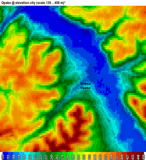
Below is the Elevation map of Opaka, which displays elevation range with different colors. Scale of the first map is from 139 to 458 m (456 to 1503 ft) with average elevation of 275.6 meters (=904 ft) [note 1]
These maps also provides idea of topography and contour of this city, they are displayed at different zoom levels. More info about maps, scale and edge coordinates you can find below images.
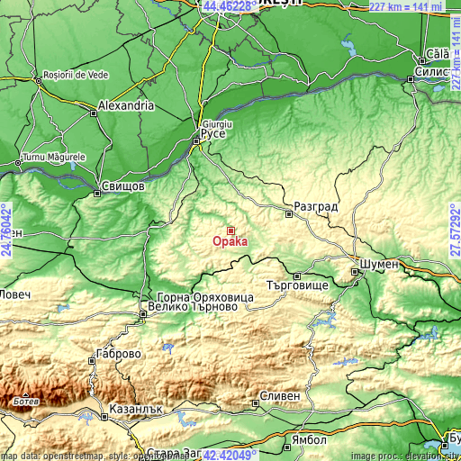
| \ | Map #1 | Topo.Map |
| Scale [m] | 139..458 m | × |
| Scale [ft] | 456..1503 ft | × |
| Average | 275.6 m = 904 ft | × |
| Width | 7.09 km = 4.4 mi | 227 km = 141.1 mi |
| Height | 7.09 km = 4.4 mi | 227 km = 141.1 mi |
| ↑Max Latitude | 43.481895° | 44.46228° |
| Latitude at center | 43.45° | 43.45° |
| ↓Min Latitude | 43.418088° | 42.42049° |
| ← Min Longitude | 26.122725° | 24.76042° |
| Longitude center | 26.16667° | 26.16667° |
| →Max Longitude | 26.210615° | 27.57292° |
Nearby cities:
Cities around Opaka sort by population:
• Razgrad elevation 197 m
29.7 km,  71°
71°
• Targovishte 186 m
39.5 km,  123°
123°
• Popovo 190 m
12.4 km,  154°
154°
• Strazhitsa 107 m
29 km,  213°
213°
• Vetovo 194 m
28.9 km,  16°
16°
• Dve Mogili 238 m
28.4 km,  303°
303°
• Tsar Kaloyan 209 m
19.7 km, 19°
• Loznitsa 265 m
36.2 km,  104°
104°
• Borovo 286 m
29.3 km,  281°
281°
• Antonovo 481 m
33.4 km,  180°
180°
• Senovo 210 m
27.5 km,  35°
35°
• Ivanovo 180 m
31.2 km,  327°
327°
Multilingual:
 En español:
Opaka elevación 224 m.
 En France:
Opaka élévation 224 m.


Sources and notes:
- [note 1] Map square and city borders are not equal. Map elevation data is calculated only from area inside that square.
- [src 1] Elevation data from geonames database provided with same terms of usage.
- [src 2] The elevation map of Opaka is generated using elevation data from NASA's 3 arcsec (90m) resolution SRTM data.
- [src 3] Base (background) map © OpenStreetMap contributors tiles are generated by Geofabrik and OpenTopoMap.
Copyright & License:
This Opaka Elevation Map is licensed under CC BY-SA. You may reuse any part from this page, if you give a proper credit by linking to this URL:
 More info on terms of use page.