Birkfeld elevation
Birkfeld (Styria, Politischer Bezirk Weiz), Austria elevation is 676 meters and Birkfeld elevation in feet is 2218 ft above sea level [src 1]. Birkfeld is a seat of a third-order administrative division (feature code) with elevation that is 167 meters (548 ft) bigger than average city elevation in Austria.
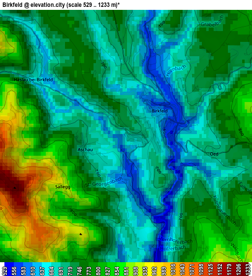
Below is the Elevation map of Birkfeld, which displays elevation range with different colors. Scale of the first map is from 529 to 1233 m (1736 to 4045 ft) with average elevation of 748.9 meters (=2457 ft) [note 1]
These maps also provides idea of topography and contour of this city, they are displayed at different zoom levels. More info about maps, scale and edge coordinates you can find below images.
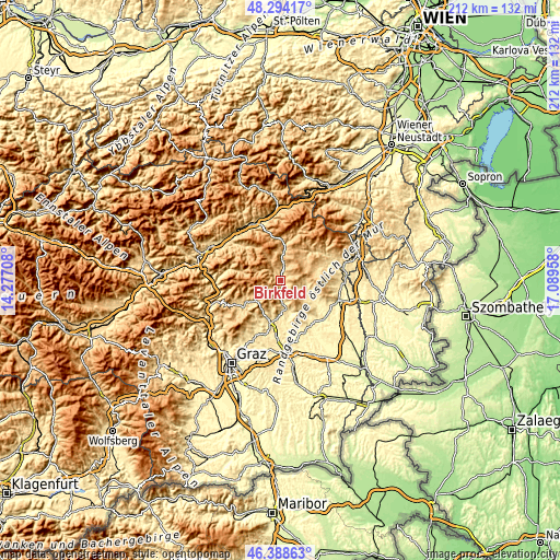
| \ | Map #1 | Topo.Map |
| Scale [m] | 529..1233 m | × |
| Scale [ft] | 1736..4045 ft | × |
| Average | 748.9 m = 2457 ft | × |
| Width | 6.62 km = 4.1 mi | 211.9 km = 131.7 mi |
| Height | 6.62 km = 4.1 mi | 211.9 km = 131.7 mi |
| ↑Max Latitude | 47.379765° | 48.29417° |
| Latitude at center | 47.35° | 47.35° |
| ↓Min Latitude | 47.320218° | 46.38863° |
| ← Min Longitude | 15.639385° | 14.27708° |
| Longitude center | 15.68333° | 15.68333° |
| →Max Longitude | 15.727275° | 17.08958° |
Nearby cities:
Cities around Birkfeld sort by population:
• Pöllau elevation 422 m
12.6 km,  116°
116°
• Strallegg 861 m
7.5 km,  24°
24°
• Baierdorf-Umgebung 675 m
7.5 km,  164°
164°
• Fischbach 997 m
10.6 km,  346°
346°
• Anger 473 m
8.4 km,  175°
175°
• Hohenau an der Raab 835 m
11.5 km,  241°
241°
• Floing 698 m
10.7 km,  153°
153°
• Naas 541 m
12.9 km,  211°
211°
• Gasen 904 m
9.5 km,  292°
292°
• Pöllauberg 625 m
13.1 km,  106°
106°
• Sankt Kathrein am Offenegg 969 m
9.4 km,  233°
233°
• Miesenbach bei Birkfeld 848 m
6.5 km,  73°
73°
Multilingual:
 En español:
Birkfeld elevación 676 m.
 En France:
Birkfeld élévation 676 m.
 Auf Deutsch:
Birkfeld höhe über dem Meeresspiegel ist 676 m.

Sources and notes:
- [note 1] Map square and city borders are not equal. Map elevation data is calculated only from area inside that square.
- [src 1] Elevation data from geonames database provided with same terms of usage.
- [src 2] The elevation map of Birkfeld is generated using elevation data from NASA's 3 arcsec (90m) resolution SRTM data.
- [src 3] Base (background) map © OpenStreetMap contributors tiles are generated by Geofabrik and OpenTopoMap.
Copyright & License:
This Birkfeld Elevation Map is licensed under CC BY-SA. You may reuse any part from this page, if you give a proper credit by linking to this URL:
 More info on terms of use page.