Pöllau elevation
Pöllau (Styria, Politischer Bezirk Hartberg-Fürstenfeld), Austria elevation is 422 meters and Pöllau elevation in feet is 1385 ft above sea level [src 1]. Pöllau is a populated place (feature code) with elevation that is 87 meters (285 ft) smaller than average city elevation in Austria.
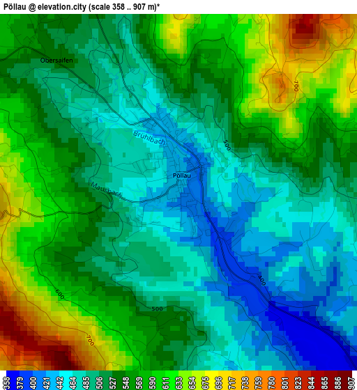
Below is the Elevation map of Pöllau, which displays elevation range with different colors. Scale of the first map is from 358 to 907 m (1175 to 2976 ft) with average elevation of 536.7 meters (=1761 ft) [note 1]
These maps also provides idea of topography and contour of this city, they are displayed at different zoom levels. More info about maps, scale and edge coordinates you can find below images.
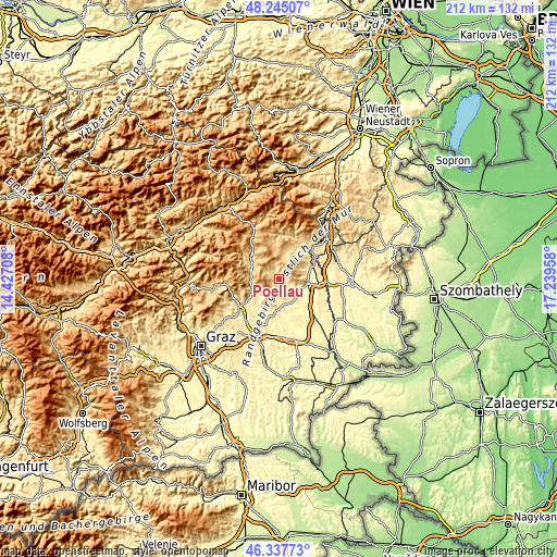
| \ | Map #1 | Topo.Map |
| Scale [m] | 358..907 m | × |
| Scale [ft] | 1175..2976 ft | × |
| Average | 536.7 m = 1761 ft | × |
| Width | 6.63 km = 4.1 mi | 212.1 km = 131.8 mi |
| Height | 6.63 km = 4.1 mi | 212.1 km = 131.8 mi |
| ↑Max Latitude | 47.329794° | 48.24507° |
| Latitude at center | 47.3° | 47.3° |
| ↓Min Latitude | 47.27019° | 46.33773° |
| ← Min Longitude | 15.789385° | 14.42708° |
| Longitude center | 15.83333° | 15.83333° |
| →Max Longitude | 15.877275° | 17.23958° |
Nearby cities:
Cities around Pöllau sort by population:
• Hartberg elevation 396 m
10.2 km,  100°
100°
• Schachen bei Vorau 714 m
9.1 km,  11°
11°
• Kaindorf 338 m
10.2 km,  144°
144°
• Baierdorf-Umgebung 675 m
9.4 km,  259°
259°
• Anger 473 m
11.1 km, 255°
• Dienersdorf 342 m
8.4 km, 142°
• Stubenberg 444 m
6.6 km,  202°
202°
• Floing 698 m
7.7 km,  238°
238°
• Kaibing 351 m
11.1 km,  180°
180°
• Stambach 601 m
8.4 km,  63°
63°
• Miesenbach bei Birkfeld 848 m
9 km,  325°
325°
• Pöllauberg 625 m
2.2 km,  34°
34°
Multilingual:
 En español:
Pöllau elevación 422 m.
 En France:
Pöllau élévation 422 m.


Sources and notes:
- [note 1] Map square and city borders are not equal. Map elevation data is calculated only from area inside that square.
- [src 1] Elevation data from geonames database provided with same terms of usage.
- [src 2] The elevation map of Pöllau is generated using elevation data from NASA's 3 arcsec (90m) resolution SRTM data.
- [src 3] Base (background) map © OpenStreetMap contributors tiles are generated by Geofabrik and OpenTopoMap.
Copyright & License:
This Pöllau Elevation Map is licensed under CC BY-SA. You may reuse any part from this page, if you give a proper credit by linking to this URL:
 More info on terms of use page.