Anger elevation
Anger (Styria, Politischer Bezirk Weiz), Austria elevation is 473 meters and Anger elevation in feet is 1552 ft above sea level [src 1]. Anger is a seat of a third-order administrative division (feature code) with elevation that is 36 meters (118 ft) smaller than average city elevation in Austria.
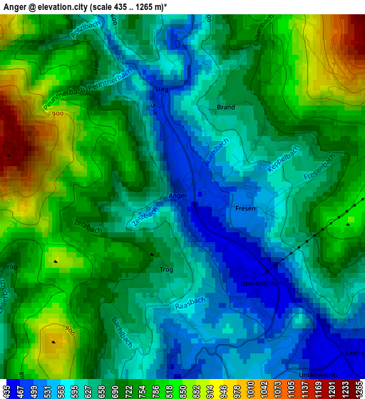
Below is the Elevation map of Anger, which displays elevation range with different colors. Scale of the first map is from 435 to 1265 m (1427 to 4150 ft) with average elevation of 688.2 meters (=2258 ft) [note 1]
These maps also provides idea of topography and contour of this city, they are displayed at different zoom levels. More info about maps, scale and edge coordinates you can find below images.
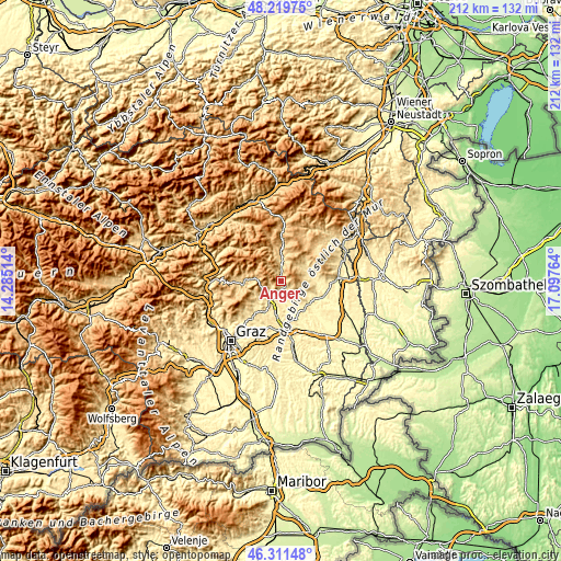
| \ | Map #1 | Topo.Map |
| Scale [m] | 435..1265 m | × |
| Scale [ft] | 1427..4150 ft | × |
| Average | 688.2 m = 2258 ft | × |
| Width | 6.63 km = 4.1 mi | 212.2 km = 131.9 mi |
| Height | 6.63 km = 4.1 mi | 212.2 km = 131.9 mi |
| ↑Max Latitude | 47.304028° | 48.21975° |
| Latitude at center | 47.27422° | 47.27422° |
| ↓Min Latitude | 47.244395° | 46.31148° |
| ← Min Longitude | 15.647445° | 14.28514° |
| Longitude center | 15.69139° | 15.69139° |
| →Max Longitude | 15.735335° | 17.09764° |
Nearby cities:
Cities around Anger sort by population:
• Weiz elevation 506 m
8.5 km,  221°
221°
• Birkfeld 676 m
8.4 km,  355°
355°
• Göttelsberg 536 m
9.4 km,  227°
227°
• Baierdorf-Umgebung 675 m
1.9 km,  49°
49°
• Krottendorf 470 m
9.3 km,  207°
207°
• Stubenberg 444 m
8.9 km,  111°
111°
• Puch bei Weiz 406 m
6.7 km,  163°
163°
• Floing 698 m
4.3 km, 105°
• Unterfladnitz 408 m
10.3 km,  190°
190°
• Siegersdorf bei Herberstein 412 m
10.8 km,  139°
139°
• Naas 541 m
7.8 km,  250°
250°
• Sankt Kathrein am Offenegg 969 m
8.6 km,  289°
289°
Multilingual:
 En español:
Anger elevación 473 m.
 En France:
Anger élévation 473 m.


Sources and notes:
- [note 1] Map square and city borders are not equal. Map elevation data is calculated only from area inside that square.
- [src 1] Elevation data from geonames database provided with same terms of usage.
- [src 2] The elevation map of Anger is generated using elevation data from NASA's 3 arcsec (90m) resolution SRTM data.
- [src 3] Base (background) map © OpenStreetMap contributors tiles are generated by Geofabrik and OpenTopoMap.
Copyright & License:
This Anger Elevation Map is licensed under CC BY-SA. You may reuse any part from this page, if you give a proper credit by linking to this URL:
 More info on terms of use page.