Fischbach elevation
Fischbach (Styria, Politischer Bezirk Weiz), Austria elevation is 997 meters and Fischbach elevation in feet is 3271 ft above sea level [src 1]. Fischbach is a seat of a third-order administrative division (feature code) with elevation that is 488 meters (1601 ft) bigger than average city elevation in Austria.
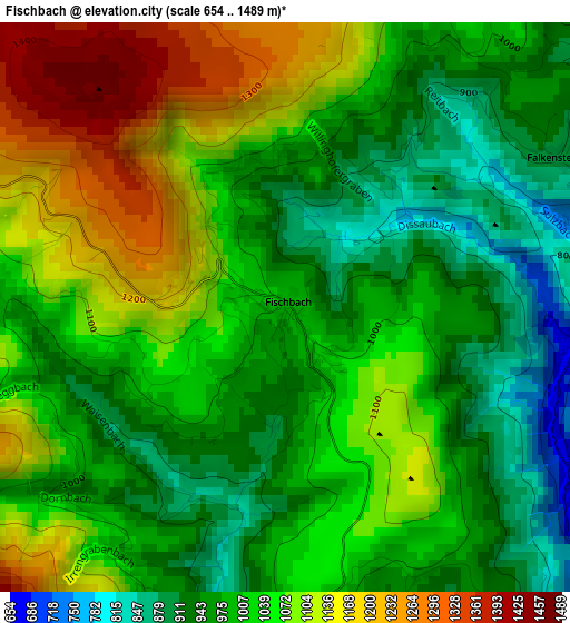
Below is the Elevation map of Fischbach, which displays elevation range with different colors. Scale of the first map is from 654 to 1489 m (2146 to 4885 ft) with average elevation of 1026.3 meters (=3367 ft) [note 1]
These maps also provides idea of topography and contour of this city, they are displayed at different zoom levels. More info about maps, scale and edge coordinates you can find below images.
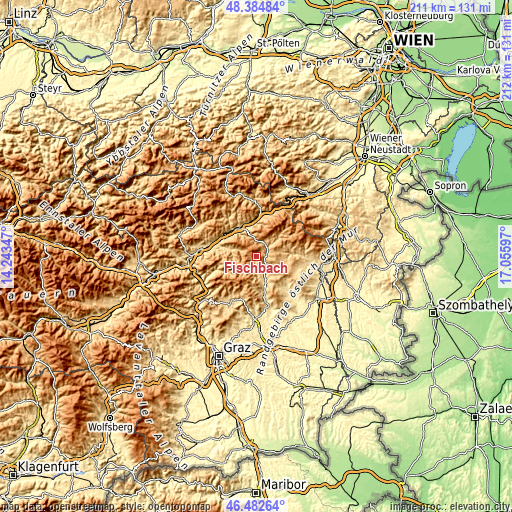
| \ | Map #1 | Topo.Map |
| Scale [m] | 654..1489 m | × |
| Scale [ft] | 2146..4885 ft | × |
| Average | 1026.3 m = 3367 ft | × |
| Width | 6.61 km = 4.1 mi | 211.5 km = 131.4 mi |
| Height | 6.61 km = 4.1 mi | 211.5 km = 131.4 mi |
| ↑Max Latitude | 47.472053° | 48.38484° |
| Latitude at center | 47.44234° | 47.44234° |
| ↓Min Latitude | 47.41261° | 46.48264° |
| ← Min Longitude | 15.605775° | 14.24347° |
| Longitude center | 15.64972° | 15.64972° |
| →Max Longitude | 15.693665° | 17.05597° |
Nearby cities:
Cities around Fischbach sort by population:
• Langenwang elevation 630 m
14 km,  349°
349°
• Krieglach 608 m
13.4 km,  330°
330°
• Birkfeld 676 m
10.6 km,  166°
166°
• Strallegg 861 m
6.6 km,  120°
120°
• Rettenegg 857 m
13.6 km,  46°
46°
• Sankt Kathrein am Hauenstein 805 m
6.2 km,  32°
32°
• Gasen 904 m
9.1 km,  223°
223°
• Sticklberg 900 m
13.8 km,  44°
44°
• Miesenbach bei Birkfeld 848 m
12.2 km,  133°
133°
• Klaffenegg 1018 m
11.8 km, 44°
• Sankt Jakob im Walde 941 m
10.4 km,  74°
74°
• Ratten 779 m
6.8 km, 47°
Multilingual:
 En español:
Fischbach elevación 997 m.
 En France:
Fischbach élévation 997 m.
 Auf Deutsch:
Fischbach höhe über dem Meeresspiegel ist 997 m.

Sources and notes:
- [note 1] Map square and city borders are not equal. Map elevation data is calculated only from area inside that square.
- [src 1] Elevation data from geonames database provided with same terms of usage.
- [src 2] The elevation map of Fischbach is generated using elevation data from NASA's 3 arcsec (90m) resolution SRTM data.
- [src 3] Base (background) map © OpenStreetMap contributors tiles are generated by Geofabrik and OpenTopoMap.
Copyright & License:
This Fischbach Elevation Map is licensed under CC BY-SA. You may reuse any part from this page, if you give a proper credit by linking to this URL:
 More info on terms of use page.