Hochwolkersdorf elevation
Hochwolkersdorf (Lower Austria, Politischer Bezirk Wiener Neustadt), Austria elevation is 623 meters and Hochwolkersdorf elevation in feet is 2044 ft above sea level [src 1]. Hochwolkersdorf is a seat of a third-order administrative division (feature code) with elevation that is 114 meters (374 ft) bigger than average city elevation in Austria.
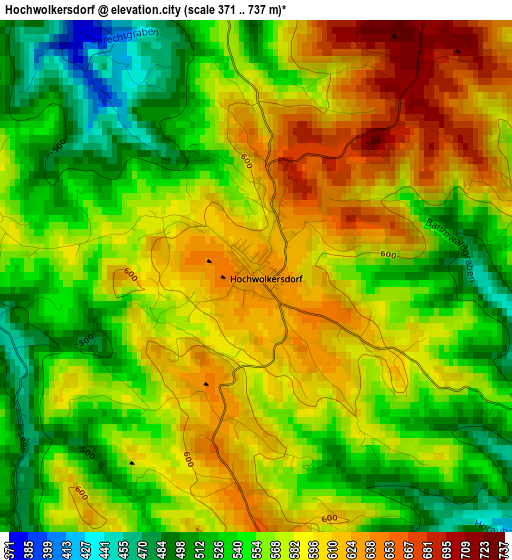
Below is the Elevation map of Hochwolkersdorf, which displays elevation range with different colors. Scale of the first map is from 371 to 737 m (1217 to 2418 ft) with average elevation of 570.4 meters (=1871 ft) [note 1]
These maps also provides idea of topography and contour of this city, they are displayed at different zoom levels. More info about maps, scale and edge coordinates you can find below images.
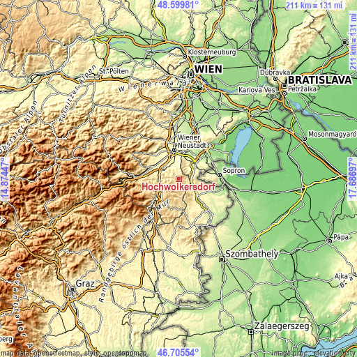
| \ | Map #1 | Topo.Map |
| Scale [m] | 371..737 m | × |
| Scale [ft] | 1217..2418 ft | × |
| Average | 570.4 m = 1871 ft | × |
| Width | 6.58 km = 4.1 mi | 210.6 km = 130.9 mi |
| Height | 6.58 km = 4.1 mi | 210.6 km = 130.9 mi |
| ↑Max Latitude | 47.690859° | 48.59981° |
| Latitude at center | 47.66127° | 47.66127° |
| ↓Min Latitude | 47.631664° | 46.70554° |
| ← Min Longitude | 16.236775° | 14.87447° |
| Longitude center | 16.28072° | 16.28072° |
| →Max Longitude | 16.324665° | 17.68697° |
Nearby cities:
Cities around Hochwolkersdorf sort by population:
• Forchtenstein elevation 347 m
7.4 km,  40°
40°
• Wiesen 314 m
9.5 km,  26°
26°
• Bad Erlach 310 m
8.9 km,  325°
325°
• Pitten 324 m
9.5 km,  310°
310°
• Wiesmath 670 m
5 km,  177°
177°
• Sieggraben 466 m
7.5 km,  98°
98°
• Frohsdorf 341 m
8.3 km,  343°
343°
• Schwarzenbach 376 m
6 km,  118°
118°
• Walpersbach 375 m
7.1 km, 330°
• Hollenthon 660 m
8.1 km,  190°
190°
• Bromberg 429 m
5.3 km,  274°
274°
• Lichtenegg 757 m
9.1 km,  221°
221°
Multilingual:
 En español:
Hochwolkersdorf elevación 623 m.
 En France:
Hochwolkersdorf élévation 623 m.
 Auf Deutsch:
Hochwolkersdorf höhe über dem Meeresspiegel ist 623 m.

Sources and notes:
- [note 1] Map square and city borders are not equal. Map elevation data is calculated only from area inside that square.
- [src 1] Elevation data from geonames database provided with same terms of usage.
- [src 2] The elevation map of Hochwolkersdorf is generated using elevation data from NASA's 3 arcsec (90m) resolution SRTM data.
- [src 3] Base (background) map © OpenStreetMap contributors tiles are generated by Geofabrik and OpenTopoMap.
Copyright & License:
This Hochwolkersdorf Elevation Map is licensed under CC BY-SA. You may reuse any part from this page, if you give a proper credit by linking to this URL:
 More info on terms of use page.