Wiesen elevation
Wiesen (Burgenland, Politischer Bezirk Mattersburg), Austria elevation is 314 meters and Wiesen elevation in feet is 1030 ft above sea level [src 1]. Wiesen is a seat of a third-order administrative division (feature code) with elevation that is 195 meters (640 ft) smaller than average city elevation in Austria.
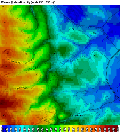
Below is the Elevation map of Wiesen, which displays elevation range with different colors. Scale of the first map is from 235 to 693 m (771 to 2274 ft) with average elevation of 398 meters (=1306 ft) [note 1]
These maps also provides idea of topography and contour of this city, they are displayed at different zoom levels. More info about maps, scale and edge coordinates you can find below images.
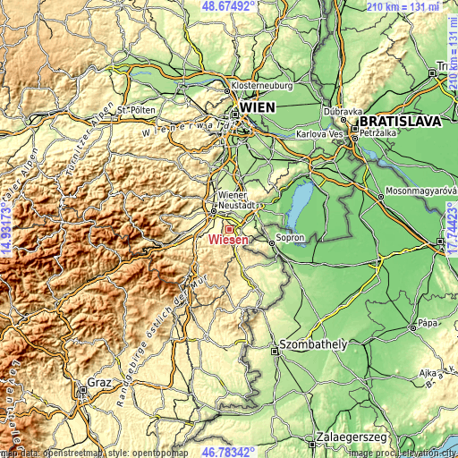
| \ | Map #1 | Topo.Map |
| Scale [m] | 235..693 m | × |
| Scale [ft] | 771..2274 ft | × |
| Average | 398 m = 1306 ft | × |
| Width | 6.57 km = 4.1 mi | 210.3 km = 130.7 mi |
| Height | 6.57 km = 4.1 mi | 210.3 km = 130.7 mi |
| ↑Max Latitude | 47.767306° | 48.67492° |
| Latitude at center | 47.73776° | 47.73776° |
| ↓Min Latitude | 47.708197° | 46.78342° |
| ← Min Longitude | 16.294035° | 14.93173° |
| Longitude center | 16.33798° | 16.33798° |
| →Max Longitude | 16.381925° | 17.74423° |
Nearby cities:
Cities around Wiesen sort by population:
• Mattersburg elevation 267 m
4.7 km,  96°
96°
• Neudörfl 268 m
7.2 km,  335°
335°
• Katzelsdorf 277 m
7 km,  313°
313°
• Pöttsching 218 m
7.8 km,  18°
18°
• Forchtenstein 347 m
3 km,  169°
169°
• Rohrbach bei Mattersburg 279 m
7.8 km,  117°
117°
• Bad Sauerbrunn 281 m
4.1 km,  350°
350°
• Marz 250 m
6.3 km,  111°
111°
• Sigless 208 m
6 km,  45°
45°
• Frohsdorf 341 m
6.6 km,  265°
265°
• Pöttelsdorf 209 m
7.7 km,  76°
76°
• Krensdorf 194 m
7.8 km, 47°
Multilingual:
 En español:
Wiesen elevación 314 m.
 En France:
Wiesen élévation 314 m.


Sources and notes:
- [note 1] Map square and city borders are not equal. Map elevation data is calculated only from area inside that square.
- [src 1] Elevation data from geonames database provided with same terms of usage.
- [src 2] The elevation map of Wiesen is generated using elevation data from NASA's 3 arcsec (90m) resolution SRTM data.
- [src 3] Base (background) map © OpenStreetMap contributors tiles are generated by Geofabrik and OpenTopoMap.
Copyright & License:
This Wiesen Elevation Map is licensed under CC BY-SA. You may reuse any part from this page, if you give a proper credit by linking to this URL:
 More info on terms of use page.