Forchtenstein elevation
Forchtenstein (Burgenland, Politischer Bezirk Mattersburg), Austria elevation is 347 meters and Forchtenstein elevation in feet is 1138 ft above sea level [src 1]. Forchtenstein is a populated place (feature code) with elevation that is 162 meters (531 ft) smaller than average city elevation in Austria.
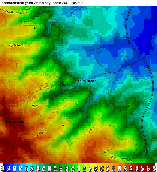
Below is the Elevation map of Forchtenstein, which displays elevation range with different colors. Scale of the first map is from 244 to 746 m (801 to 2448 ft) with average elevation of 454.8 meters (=1492 ft) [note 1]
These maps also provides idea of topography and contour of this city, they are displayed at different zoom levels. More info about maps, scale and edge coordinates you can find below images.
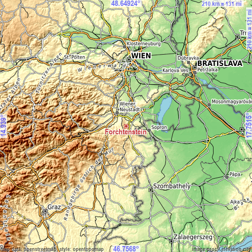
| \ | Map #1 | Topo.Map |
| Scale [m] | 244..746 m | × |
| Scale [ft] | 801..2448 ft | × |
| Average | 454.8 m = 1492 ft | × |
| Width | 6.58 km = 4.1 mi | 210.4 km = 130.7 mi |
| Height | 6.58 km = 4.1 mi | 210.4 km = 130.7 mi |
| ↑Max Latitude | 47.741171° | 48.64924° |
| Latitude at center | 47.71161° | 47.71161° |
| ↓Min Latitude | 47.682032° | 46.7568° |
| ← Min Longitude | 16.301305° | 14.939° |
| Longitude center | 16.34525° | 16.34525° |
| →Max Longitude | 16.389195° | 17.7515° |
Nearby cities:
Cities around Forchtenstein sort by population:
• Mattersburg elevation 267 m
4.8 km,  59°
59°
• Rohrbach bei Mattersburg 279 m
6.4 km,  96°
96°
• Wiesen 314 m
3 km,  349°
349°
• Bad Sauerbrunn 281 m
7.1 km, 349°
• Marz 250 m
5.4 km,  83°
83°
• Sieggraben 466 m
7.2 km,  158°
158°
• Sigless 208 m
8 km,  27°
27°
• Frohsdorf 341 m
7.5 km,  288°
288°
• Schwarzenbach 376 m
8.5 km,  177°
177°
• Hochwolkersdorf 623 m
7.4 km,  220°
220°
• Walpersbach 375 m
8.4 km,  273°
273°
• Pöttelsdorf 209 m
8.4 km, 56°
Multilingual:
 En español:
Forchtenstein elevación 347 m.
 En France:
Forchtenstein élévation 347 m.
 Auf Deutsch:
Forchtenau höhe über dem Meeresspiegel ist 347 m.

Sources and notes:
- [note 1] Map square and city borders are not equal. Map elevation data is calculated only from area inside that square.
- [src 1] Elevation data from geonames database provided with same terms of usage.
- [src 2] The elevation map of Forchtenstein is generated using elevation data from NASA's 3 arcsec (90m) resolution SRTM data.
- [src 3] Base (background) map © OpenStreetMap contributors tiles are generated by Geofabrik and OpenTopoMap.
Copyright & License:
This Forchtenstein Elevation Map is licensed under CC BY-SA. You may reuse any part from this page, if you give a proper credit by linking to this URL:
 More info on terms of use page.