Lichtenegg elevation
Lichtenegg (Lower Austria, Politischer Bezirk Wiener Neustadt), Austria elevation is 757 meters and Lichtenegg elevation in feet is 2484 ft above sea level [src 1]. Lichtenegg is a seat of a third-order administrative division (feature code) with elevation that is 248 meters (814 ft) bigger than average city elevation in Austria.
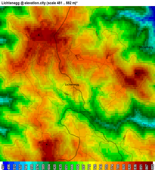
Below is the Elevation map of Lichtenegg, which displays elevation range with different colors. Scale of the first map is from 481 to 882 m (1578 to 2894 ft) with average elevation of 723.2 meters (=2373 ft) [note 1]
These maps also provides idea of topography and contour of this city, they are displayed at different zoom levels. More info about maps, scale and edge coordinates you can find below images.
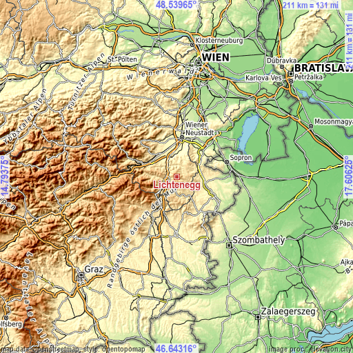
| \ | Map #1 | Topo.Map |
| Scale [m] | 481..882 m | × |
| Scale [ft] | 1578..2894 ft | × |
| Average | 723.2 m = 2373 ft | × |
| Width | 6.59 km = 4.1 mi | 210.9 km = 131 mi |
| Height | 6.59 km = 4.1 mi | 210.9 km = 131 mi |
| ↑Max Latitude | 47.629624° | 48.53965° |
| Latitude at center | 47.6° | 47.6° |
| ↓Min Latitude | 47.570359° | 46.64316° |
| ← Min Longitude | 16.156055° | 14.79375° |
| Longitude center | 16.2° | 16.2° |
| →Max Longitude | 16.243945° | 17.60625° |
Nearby cities:
Cities around Lichtenegg sort by population:
• Krumbach Markt elevation 640 m
9.3 km,  187°
187°
• Aspang Markt 553 m
10.4 km,  237°
237°
• Wiesmath 670 m
6.5 km,  73°
73°
• Grimmenstein 404 m
5.7 km,  288°
288°
• Edlitz 453 m
4.5 km,  267°
267°
• Hochwolkersdorf 623 m
9.1 km,  41°
41°
• Zöbern 630 m
10.8 km,  208°
208°
• Warth 466 m
8.4 km,  311°
311°
• Thomasberg 674 m
6.2 km,  233°
233°
• Hollenthon 660 m
4.7 km,  104°
104°
• Bromberg 429 m
7.3 km,  5°
5°
• Tiefenbach 545 m
7.3 km,  171°
171°
Multilingual:
 En español:
Lichtenegg elevación 757 m.
 En France:
Lichtenegg élévation 757 m.
 Auf Deutsch:
Lichtenegg höhe über dem Meeresspiegel ist 757 m.

Sources and notes:
- [note 1] Map square and city borders are not equal. Map elevation data is calculated only from area inside that square.
- [src 1] Elevation data from geonames database provided with same terms of usage.
- [src 2] The elevation map of Lichtenegg is generated using elevation data from NASA's 3 arcsec (90m) resolution SRTM data.
- [src 3] Base (background) map © OpenStreetMap contributors tiles are generated by Geofabrik and OpenTopoMap.
Copyright & License:
This Lichtenegg Elevation Map is licensed under CC BY-SA. You may reuse any part from this page, if you give a proper credit by linking to this URL:
 More info on terms of use page.