Edlitz elevation
Edlitz (Lower Austria, Politischer Bezirk Neunkirchen), Austria elevation is 453 meters and Edlitz elevation in feet is 1486 ft above sea level [src 1]. Edlitz is a seat of a third-order administrative division (feature code) with elevation that is 56 meters (184 ft) smaller than average city elevation in Austria.
Below is the Elevation map of Edlitz, which displays elevation range with different colors. Scale of the first map is from 393 to 863 m (1289 to 2831 ft) with average elevation of 624.6 meters (=2049 ft) [note 1]
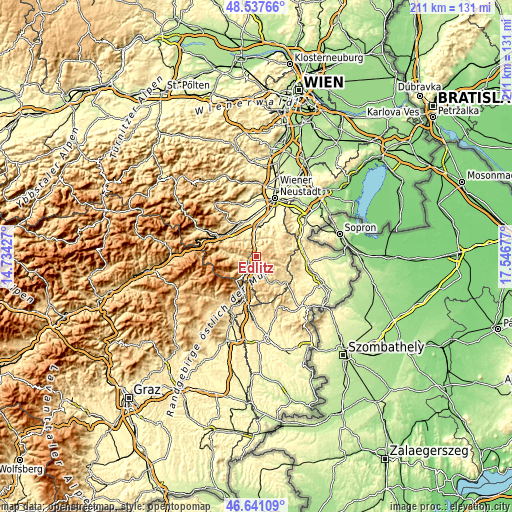
These maps also provides idea of topography and contour of this city, they are displayed at different zoom levels. More info about maps, scale and edge coordinates you can find below images.
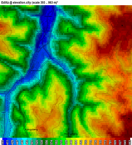
| \ | Map #1 | Topo.Map |
| Scale [m] | 393..863 m | × |
| Scale [ft] | 1289..2831 ft | × |
| Average | 624.6 m = 2049 ft | × |
| Width | 6.59 km = 4.1 mi | 210.9 km = 131 mi |
| Height | 6.59 km = 4.1 mi | 210.9 km = 131 mi |
| ↑Max Latitude | 47.627595° | 48.53766° |
| Latitude at center | 47.59797° | 47.59797° |
| ↓Min Latitude | 47.568328° | 46.64109° |
| ← Min Longitude | 16.096575° | 14.73427° |
| Longitude center | 16.14052° | 16.14052° |
| →Max Longitude | 16.184465° | 17.54677° |
Nearby cities:
Cities around Edlitz sort by population:
• Krumbach Markt elevation 640 m
9.6 km,  160°
160°
• Aspang Markt 553 m
6.8 km,  218°
218°
• Grimmenstein 404 m
2.3 km,  334°
334°
• Feistritz am Wechsel 492 m
6.8 km,  271°
271°
• Zöbern 630 m
9.3 km,  184°
184°
• Warth 466 m
6.1 km,  342°
342°
• Thomasberg 674 m
3.5 km,  188°
188°
• Hollenthon 660 m
9.1 km,  96°
96°
• Sankt Corona am Wechsel 866 m
10.7 km,  261°
261°
• Bromberg 429 m
9.1 km,  34°
34°
• Lichtenegg 757 m
4.5 km,  87°
87°
• Tiefenbach 545 m
8.9 km,  141°
141°
Multilingual:
 En español:
Edlitz elevación 453 m.
 En France:
Edlitz élévation 453 m.


Sources and notes:
- [note 1] Map square and city borders are not equal. Map elevation data is calculated only from area inside that square.
- [src 1] Elevation data from geonames database provided with same terms of usage.
- [src 2] The elevation map of Edlitz is generated using elevation data from NASA's 3 arcsec (90m) resolution SRTM data.
- [src 3] Base (background) map © OpenStreetMap contributors tiles are generated by Geofabrik and OpenTopoMap.
Copyright & License:
This Edlitz Elevation Map is licensed under CC BY-SA. You may reuse any part from this page, if you give a proper credit by linking to this URL:
 More info on terms of use page.