Wilfleinsdorf elevation
Wilfleinsdorf (Lower Austria, Politischer Bezirk Bruck an der Leitha), Austria elevation is 156 meters and Wilfleinsdorf elevation in feet is 512 ft above sea level [src 1]. Wilfleinsdorf is a populated place (feature code) with elevation that is 353 meters (1158 ft) smaller than average city elevation in Austria.
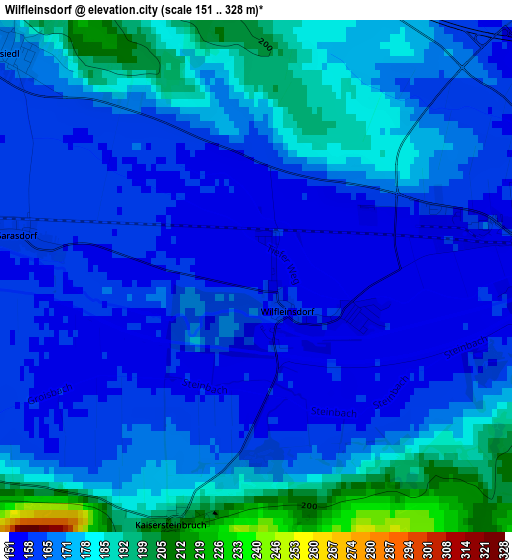
Below is the Elevation map of Wilfleinsdorf, which displays elevation range with different colors. Scale of the first map is from 151 to 328 m (495 to 1076 ft) with average elevation of 170.3 meters (=559 ft) [note 1]
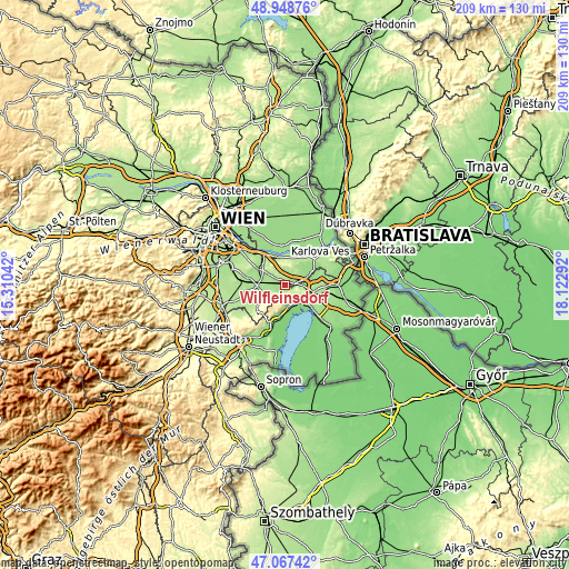
These maps also provides idea of topography and contour of this city, they are displayed at different zoom levels. More info about maps, scale and edge coordinates you can find below images.
| \ | Map #1 | Topo.Map |
| Scale [m] | 151..328 m | × |
| Scale [ft] | 495..1076 ft | × |
| Average | 170.3 m = 559 ft | × |
| Width | 6.54 km = 4.1 mi | 209.2 km = 130 mi |
| Height | 6.54 km = 4.1 mi | 209.2 km = 130 mi |
| ↑Max Latitude | 48.046057° | 48.94876° |
| Latitude at center | 48.01667° | 48.01667° |
| ↓Min Latitude | 47.987266° | 47.06742° |
| ← Min Longitude | 16.672725° | 15.31042° |
| Longitude center | 16.71667° | 16.71667° |
| →Max Longitude | 16.760615° | 18.12292° |
Nearby cities:
Cities around Wilfleinsdorf sort by population:
• Bruck an der Leitha elevation 154 m
3.7 km,  90°
90°
• Mannersdorf am Leithagebirge 228 m
10.3 km,  237°
237°
• Bruckneudorf 160 m
5 km, 90°
• Sommerein 257 m
6.2 km,  233°
233°
• Breitenbrunn 148 m
8.1 km,  172°
172°
• Jois 138 m
8.5 km,  136°
136°
• Götzendorf an der Leitha 168 m
9.9 km,  270°
270°
• Winden am See 131 m
7.8 km,  161°
161°
• Höflein 181 m
7.4 km,  41°
41°
• Margarethen am Moos 164 m
8.9 km,  282°
282°
• Maria Ellend 185 m
9.6 km,  345°
345°
• Trautmannsdorf an der Leitha 167 m
6.3 km, 277°
Multilingual:
 En español:
Wilfleinsdorf elevación 156 m.
 En France:
Wilfleinsdorf élévation 156 m.
 Auf Deutsch:
Wilfleinsdorf höhe über dem Meeresspiegel ist 156 m.

Sources and notes:
- [note 1] Map square and city borders are not equal. Map elevation data is calculated only from area inside that square.
- [src 1] Elevation data from geonames database provided with same terms of usage.
- [src 2] The elevation map of Wilfleinsdorf is generated using elevation data from NASA's 3 arcsec (90m) resolution SRTM data.
- [src 3] Base (background) map © OpenStreetMap contributors tiles are generated by Geofabrik and OpenTopoMap.
Copyright & License:
This Wilfleinsdorf Elevation Map is licensed under CC BY-SA. You may reuse any part from this page, if you give a proper credit by linking to this URL:
 More info on terms of use page.