Breitenbrunn elevation
Breitenbrunn (Burgenland, Eisenstadt-Umgebung), Austria elevation is 148 meters and Breitenbrunn elevation in feet is 486 ft above sea level [src 1]. Breitenbrunn is a seat of a third-order administrative division (feature code) with elevation that is 361 meters (1184 ft) smaller than average city elevation in Austria.
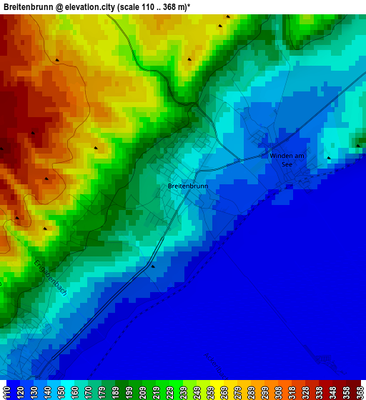
Below is the Elevation map of Breitenbrunn, which displays elevation range with different colors. Scale of the first map is from 110 to 368 m (361 to 1207 ft) with average elevation of 179.3 meters (=588 ft) [note 1]
These maps also provides idea of topography and contour of this city, they are displayed at different zoom levels. More info about maps, scale and edge coordinates you can find below images.
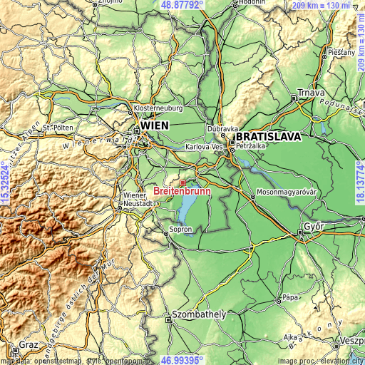
| \ | Map #1 | Topo.Map |
| Scale [m] | 110..368 m | × |
| Scale [ft] | 361..1207 ft | × |
| Average | 179.3 m = 588 ft | × |
| Width | 6.55 km = 4.1 mi | 209.5 km = 130.2 mi |
| Height | 6.55 km = 4.1 mi | 209.5 km = 130.2 mi |
| ↑Max Latitude | 47.973948° | 48.87792° |
| Latitude at center | 47.94452° | 47.94452° |
| ↓Min Latitude | 47.915075° | 46.99395° |
| ← Min Longitude | 16.687545° | 15.32524° |
| Longitude center | 16.73149° | 16.73149° |
| →Max Longitude | 16.775435° | 18.13774° |
Nearby cities:
Cities around Breitenbrunn sort by population:
• Neusiedl am See elevation 125 m
8.2 km,  86°
86°
• Bruck an der Leitha 154 m
8.4 km,  18°
18°
• Mannersdorf am Leithagebirge 228 m
10.1 km,  284°
284°
• Purbach am Neusiedler See 126 m
4.4 km,  217°
217°
• Bruckneudorf 160 m
8.9 km,  25°
25°
• Weiden am See 126 m
10.5 km,  101°
101°
• Sommerein 257 m
7.4 km,  305°
305°
• Donnerskirchen 148 m
8.5 km,  228°
228°
• Jois 138 m
5.2 km,  68°
68°
• Hof am Leithaberge 218 m
11.1 km,  273°
273°
• Winden am See 131 m
1.5 km, 66°
• Wilfleinsdorf 156 m
8.1 km,  352°
352°
Multilingual:
 En español:
Breitenbrunn elevación 148 m.
 En France:
Breitenbrunn élévation 148 m.
 Auf Deutsch:
Breitenbrunn am Neusiedler See höhe über dem Meeresspiegel ist 148 m.

Sources and notes:
- [note 1] Map square and city borders are not equal. Map elevation data is calculated only from area inside that square.
- [src 1] Elevation data from geonames database provided with same terms of usage.
- [src 2] The elevation map of Breitenbrunn is generated using elevation data from NASA's 3 arcsec (90m) resolution SRTM data.
- [src 3] Base (background) map © OpenStreetMap contributors tiles are generated by Geofabrik and OpenTopoMap.
Copyright & License:
This Breitenbrunn Elevation Map is licensed under CC BY-SA. You may reuse any part from this page, if you give a proper credit by linking to this URL:
 More info on terms of use page.