Bruck an der Leitha elevation
Bruck an der Leitha (Lower Austria, Politischer Bezirk Bruck an der Leitha), Austria elevation is 154 meters and Bruck an der Leitha elevation in feet is 505 ft above sea level [src 1]. Bruck an der Leitha is a seat of a third-order administrative division (feature code) with elevation that is 355 meters (1165 ft) smaller than average city elevation in Austria.
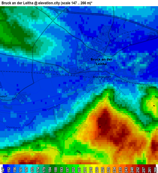
Below is the Elevation map of Bruck an der Leitha, which displays elevation range with different colors. Scale of the first map is from 147 to 266 m (482 to 873 ft) with average elevation of 177.7 meters (=583 ft) [note 1]
These maps also provides idea of topography and contour of this city, they are displayed at different zoom levels. More info about maps, scale and edge coordinates you can find below images.
| \ | Map #1 | Map #2 | Topo.Map |
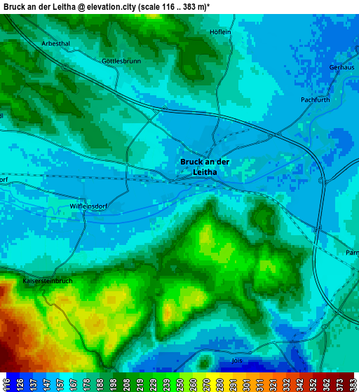
| Scale [m] | 147..266 m | 116..383 m | × |
| Scale [ft] | 482..873 ft | 381..1257 ft | × |
| Average | 177.7 m = 583 ft | 183.2 m = 601 ft | × |
| Width | 6.54 km = 4.1 mi | 13.07 km = 8.1 mi | 209.2 km = 130 mi |
| Height | 6.54 km = 4.1 mi | 13.07 km = 8.1 mi | 209.2 km = 130 mi |
| ↑Max Latitude | 48.046057° | 48.075428° | 48.94876° |
| Latitude at center | 48.01667° | 48.01667° | 48.01667° |
| ↓Min Latitude | 47.987266° | 47.957845° | 47.06742° |
| ← Min Longitude | 16.722725° | 16.678779° | 15.36042° |
| Longitude center | 16.76667° | 16.76667° | 16.76667° |
| →Max Longitude | 16.810615° | 16.854561° | 18.17292° |
Nearby cities:
Cities around Bruck an der Leitha sort by population:
• Neusiedl am See elevation 125 m
9.4 km,  143°
143°
• Parndorf 181 m
7.2 km,  105°
105°
• Bruckneudorf 160 m
1.2 km,  90°
90°
• Sommerein 257 m
9.4 km,  246°
246°
• Breitenbrunn 148 m
8.4 km,  198°
198°
• Jois 138 m
6.5 km,  160°
160°
• Winden am See 131 m
7.5 km,  189°
189°
• Höflein 181 m
5.7 km,  12°
12°
• Wilfleinsdorf 156 m
3.7 km,  270°
270°
• Trautmannsdorf an der Leitha 167 m
10 km, 274°
• Rohrau 144 m
8.3 km,  48°
48°
• Scharndorf 188 m
8.9 km,  15°
15°
Multilingual:
 En español:
Bruck an der Leitha elevación 154 m.
 En France:
Bruck an der Leitha élévation 154 m.
 Auf Deutsch:
Bruck an der Leitha höhe über dem Meeresspiegel ist 154 m.
 На русском:
Брук-ан-дер-Лайта, Брукк-ан-дер-Лайта высота над уровнем моря 154 м
Sources and notes:
- [note 1] Map square and city borders are not equal. Map elevation data is calculated only from area inside that square.
- [src 1] Elevation data from geonames database provided with same terms of usage.
- [src 2] The elevation map of Bruck an der Leitha is generated using elevation data from NASA's 3 arcsec (90m) resolution SRTM data.
- [src 3] Base (background) map © OpenStreetMap contributors tiles are generated by Geofabrik and OpenTopoMap.
Copyright & License:
This Bruck an der Leitha Elevation Map is licensed under CC BY-SA. You may reuse any part from this page, if you give a proper credit by linking to this URL:
 More info on terms of use page.