General Pinto elevation
General Pinto (Buenos Aires, Partido de General Pinto), Argentina elevation is 101 meters and General Pinto elevation in feet is 331 ft above sea level [src 1]. General Pinto is a seat of a second-order administrative division (feature code) with elevation that is 249 meters (817 ft) smaller than average city elevation in Argentina.
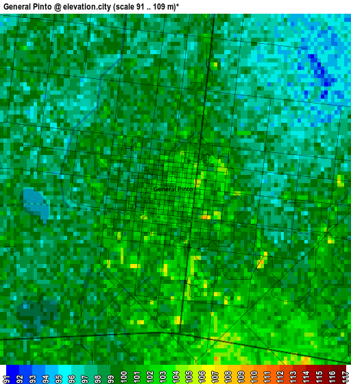
Below is the Elevation map of General Pinto, which displays elevation range with different colors. Scale of the first map is from 91 to 109 m (299 to 358 ft) with average elevation of 98.8 meters (=324 ft) [note 1]
These maps also provides idea of topography and contour of this city, they are displayed at different zoom levels. More info about maps, scale and edge coordinates you can find below images.
| \ | Map #1 | Topo.Map |
| Scale [m] | 91..109 m | × |
| Scale [ft] | 299..358 ft | × |
| Average | 98.8 m = 324 ft | × |
| Width | 8.03 km = 5 mi | 256.9 km = 159.6 mi |
| Height | 8.03 km = 5 mi | 256.9 km = 159.6 mi |
| ↑Max Latitude | -34.728481° | -33.60131° |
| Latitude at center | -34.76459° | -34.76459° |
| ↓Min Latitude | -34.800683° | -35.9117° |
| ← Min Longitude | -61.934875° | -63.29718° |
| Longitude center | -61.89093° | -61.89093° |
| →Max Longitude | -61.846985° | -60.48468° |
Nearby cities:
Cities around General Pinto sort by population:
• Junín elevation 83 m
89 km,  76°
76°
• Lincoln 92 m
34.8 km,  108°
108°
• Rufino 118 m
93.3 km,  306°
306°
• General Villegas 112 m
106.5 km,  253°
253°
• Villa Cañás 104 m
88.3 km,  17°
17°
• Tres Algarrobos 108 m
93.6 km,  239°
239°
• Carlos Casares 81 m
106.7 km,  153°
153°
• Carlos Tejedor 96 m
84.9 km,  214°
214°
• General Viamonte 73 m
82.3 km, 108°
• General Arenales 90 m
74.3 km,  46°
46°
• Florentino Ameghino 116 m
53.3 km,  260°
260°
• Vedia 94 m
43.8 km, 46°
Multilingual:
 En español:
General Pinto elevación 101 m.
 En France:
General Pinto élévation 101 m.
 Auf Deutsch:
General Pinto höhe über dem Meeresspiegel ist 101 m.

Sources and notes:
- [note 1] Map square and city borders are not equal. Map elevation data is calculated only from area inside that square.
- [src 1] Elevation data from geonames database provided with same terms of usage.
- [src 2] The elevation map of General Pinto is generated using elevation data from NASA's 3 arcsec (90m) resolution SRTM data.
- [src 3] Base (background) map © OpenStreetMap contributors tiles are generated by Geofabrik and OpenTopoMap.
Copyright & License:
This General Pinto Elevation Map is licensed under CC BY-SA. You may reuse any part from this page, if you give a proper credit by linking to this URL:
 More info on terms of use page.