Lincoln elevation
Lincoln (Buenos Aires, Partido de Lincoln), Argentina elevation is 92 meters and Lincoln elevation in feet is 302 ft above sea level [src 1]. Lincoln is a seat of a second-order administrative division (feature code) with elevation that is 258 meters (846 ft) smaller than average city elevation in Argentina.
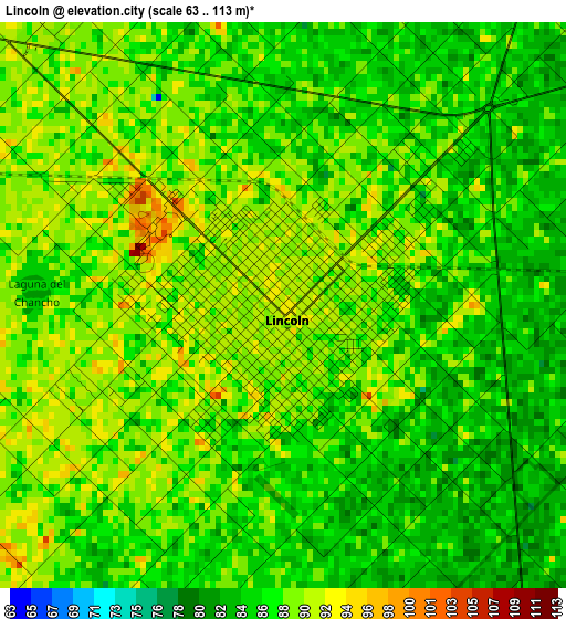
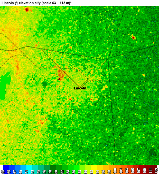
Below is the Elevation map of Lincoln, which displays elevation range with different colors. Scale of the first map is from 63 to 113 m (207 to 371 ft) with average elevation of 87.4 meters (=287 ft) [note 1]
These maps also provides idea of topography and contour of this city, they are displayed at different zoom levels. More info about maps, scale and edge coordinates you can find below images.
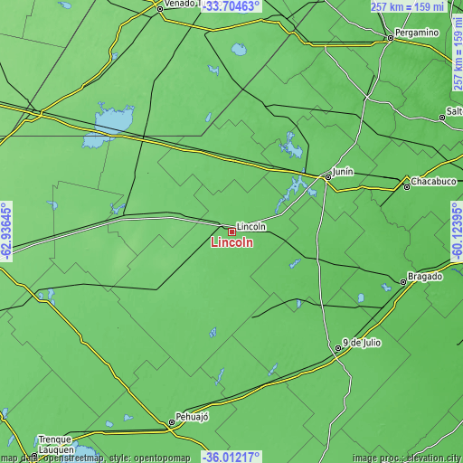
| \ | Map #1 | Map #2 | Topo.Map |
| Scale [m] | 63..113 m | 63..113 m | × |
| Scale [ft] | 207..371 ft | 207..371 ft | × |
| Average | 87.4 m = 287 ft | 86.6 m = 284 ft | × |
| Width | 8.02 km = 5 mi | 16.04 km = 10 mi | 256.6 km = 159.4 mi |
| Height | 8.02 km = 5 mi | 16.04 km = 10 mi | 256.6 km = 159.4 mi |
| ↑Max Latitude | -34.830426° | -34.794345° | -33.70463° |
| Latitude at center | -34.86649° | -34.86649° | -34.86649° |
| ↓Min Latitude | -34.902539° | -34.938571° | -36.01217° |
| ← Min Longitude | -61.574145° | -61.618091° | -62.93645° |
| Longitude center | -61.5302° | -61.5302° | -61.5302° |
| →Max Longitude | -61.486255° | -61.442309° | -60.12395° |
Nearby cities:
Cities around Lincoln sort by population:
• Junín elevation 83 m
62.2 km,  59°
59°
• Nueve de Julio 80 m
87.1 km,  137°
137°
• Chacabuco 73 m
99.7 km,  75°
75°
• Villa Cañás 104 m
96 km,  355°
355°
• Carlos Tejedor 96 m
100 km,  234°
234°
• Bragado 62 m
98.9 km,  106°
106°
• Florentino Ameghino 116 m
85.5 km,  271°
271°
• Carlos Casares 81 m
85.4 km,  169°
169°
• General Arenales 90 m
66 km,  18°
18°
• General Viamonte 73 m
47.5 km, 108°
• Vedia 94 m
41.3 km, 358°
• General Pinto 101 m
34.8 km,  288°
288°
Multilingual:
 En español:
Lincoln elevación 92 m.
 En France:
Lincoln élévation 92 m.


Sources and notes:
- [note 1] Map square and city borders are not equal. Map elevation data is calculated only from area inside that square.
- [src 1] Elevation data from geonames database provided with same terms of usage.
- [src 2] The elevation map of Lincoln is generated using elevation data from NASA's 3 arcsec (90m) resolution SRTM data.
- [src 3] Base (background) map © OpenStreetMap contributors tiles are generated by Geofabrik and OpenTopoMap.
Copyright & License:
This Lincoln Elevation Map is licensed under CC BY-SA. You may reuse any part from this page, if you give a proper credit by linking to this URL:
 More info on terms of use page.