Villa Cañás elevation
Villa Cañás (Santa Fe, General López Department), Argentina elevation is 104 meters and Villa Cañás elevation in feet is 341 ft above sea level [src 1]. Villa Cañás is a populated place (feature code) with elevation that is 246 meters (807 ft) smaller than average city elevation in Argentina.
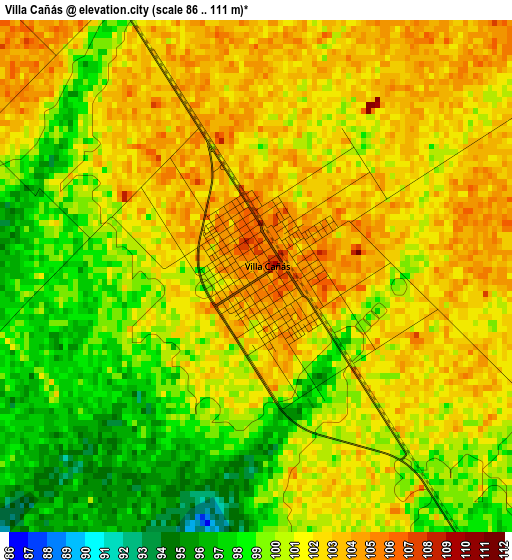
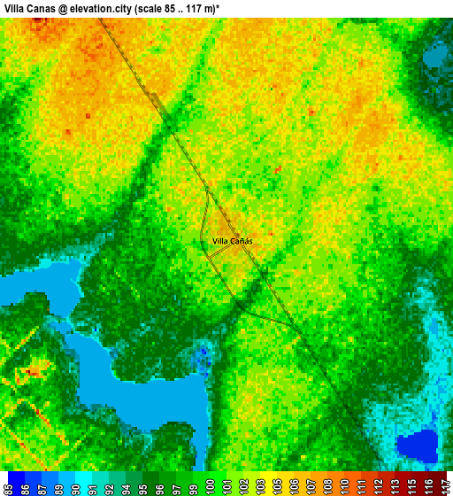
Below is the Elevation map of Villa Cañás, which displays elevation range with different colors. Scale of the first map is from 86 to 111 m (282 to 364 ft) with average elevation of 100.5 meters (=330 ft) [note 1]
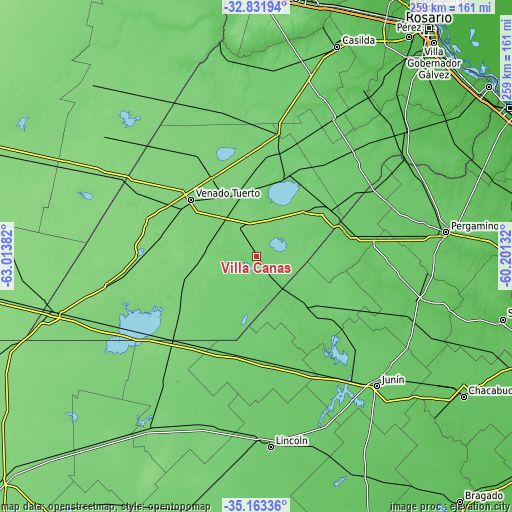
These maps also provides idea of topography and contour of this city, they are displayed at different zoom levels. More info about maps, scale and edge coordinates you can find below images.
| \ | Map #1 | Map #2 | Topo.Map |
| Scale [m] | 86..111 m | 85..117 m | × |
| Scale [ft] | 282..364 ft | 279..384 ft | × |
| Average | 100.5 m = 330 ft | 99.6 m = 327 ft | × |
| Width | 8.1 km = 5 mi | 16.2 km = 10.1 mi | 259.2 km = 161.1 mi |
| Height | 8.1 km = 5 mi | 16.2 km = 10.1 mi | 259.2 km = 161.1 mi |
| ↑Max Latitude | -33.969212° | -33.932759° | -32.83194° |
| Latitude at center | -34.00565° | -34.00565° | -34.00565° |
| ↓Min Latitude | -34.042072° | -34.078479° | -35.16336° |
| ← Min Longitude | -61.651515° | -61.695461° | -63.01382° |
| Longitude center | -61.60757° | -61.60757° | -61.60757° |
| →Max Longitude | -61.563625° | -61.519679° | -60.20132° |
Nearby cities:
Cities around Villa Cañás sort by population:
• Junín elevation 83 m
88.6 km,  136°
136°
• Venado Tuerto 117 m
44.1 km,  310°
310°
• Firmat 109 m
61.8 km,  10°
10°
• Arias 127 m
83.7 km,  298°
298°
• Chañar Ladeado 116 m
85.5 km,  332°
332°
• Cavanagh 123 m
89.7 km, 311°
• General Pinto 101 m
88.3 km,  197°
197°
• Rojas 73 m
83.1 km,  104°
104°
• Vedia 94 m
54.8 km,  173°
173°
• Colón 91 m
48.3 km,  75°
75°
• General Arenales 90 m
43.2 km, 139°
• Melincué 91 m
41.1 km,  20°
20°
Multilingual:
 En español:
Villa Cañás elevación 104 m.
 En France:
Villa Cañás élévation 104 m.
 Auf Deutsch:
Villa Cañás höhe über dem Meeresspiegel ist 104 m.

Sources and notes:
- [note 1] Map square and city borders are not equal. Map elevation data is calculated only from area inside that square.
- [src 1] Elevation data from geonames database provided with same terms of usage.
- [src 2] The elevation map of Villa Cañás is generated using elevation data from NASA's 3 arcsec (90m) resolution SRTM data.
- [src 3] Base (background) map © OpenStreetMap contributors tiles are generated by Geofabrik and OpenTopoMap.
Copyright & License:
This Villa Cañás Elevation Map is licensed under CC BY-SA. You may reuse any part from this page, if you give a proper credit by linking to this URL:
 More info on terms of use page.