Junín elevation
Junín (Buenos Aires, Partido de Junín), Argentina elevation is 83 meters and Junín elevation in feet is 272 ft above sea level [src 1]. Junín is a seat of a second-order administrative division (feature code) with elevation that is 267 meters (876 ft) smaller than average city elevation in Argentina.
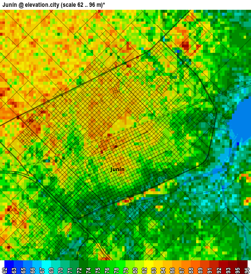
Below is the Elevation map of Junín, which displays elevation range with different colors. Scale of the first map is from 62 to 96 m (203 to 315 ft) with average elevation of 78.7 meters (=258 ft) [note 1]
These maps also provides idea of topography and contour of this city, they are displayed at different zoom levels. More info about maps, scale and edge coordinates you can find below images.
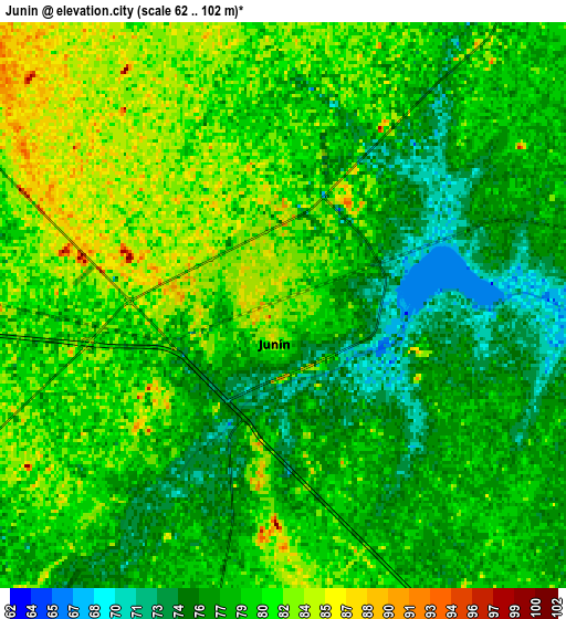
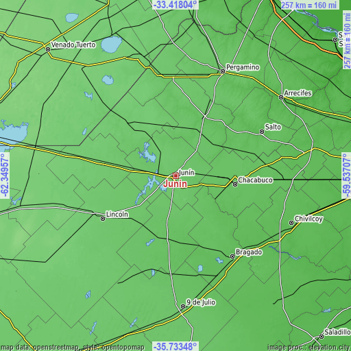
| \ | Map #1 | Map #2 | Topo.Map |
| Scale [m] | 62..96 m | 62..102 m | × |
| Scale [ft] | 203..315 ft | 203..335 ft | × |
| Average | 78.7 m = 258 ft | 79 m = 259 ft | × |
| Width | 8.05 km = 5 mi | 16.09 km = 10 mi | 257.5 km = 160 mi |
| Height | 8.05 km = 5 mi | 16.09 km = 10 mi | 257.5 km = 160 mi |
| ↑Max Latitude | -34.547632° | -34.511428° | -33.41804° |
| Latitude at center | -34.58382° | -34.58382° | -34.58382° |
| ↓Min Latitude | -34.619992° | -34.656149° | -35.73348° |
| ← Min Longitude | -60.987265° | -61.031211° | -62.34957° |
| Longitude center | -60.94332° | -60.94332° | -60.94332° |
| →Max Longitude | -60.899375° | -60.855429° | -59.53707° |
Nearby cities:
Cities around Junín sort by population:
• Pergamino elevation 69 m
84.3 km,  23°
23°
• Lincoln 92 m
62.2 km,  239°
239°
• Chacabuco 73 m
43.4 km,  98°
98°
• Villa Cañás 104 m
88.6 km,  316°
316°
• Alberti 54 m
78.4 km,  128°
128°
• Colón 91 m
77.9 km,  349°
349°
• Bragado 62 m
72.5 km,  145°
145°
• Salto 55 m
71 km,  62°
62°
• Vedia 94 m
55.6 km,  280°
280°
• Rojas 73 m
47.2 km, 23°
• General Viamonte 73 m
47 km,  190°
190°
• General Arenales 90 m
45.6 km,  313°
313°
Multilingual:
 En español:
Junín elevación 83 m.
 En France:
Junín élévation 83 m.


Sources and notes:
- [note 1] Map square and city borders are not equal. Map elevation data is calculated only from area inside that square.
- [src 1] Elevation data from geonames database provided with same terms of usage.
- [src 2] The elevation map of Junín is generated using elevation data from NASA's 3 arcsec (90m) resolution SRTM data.
- [src 3] Base (background) map © OpenStreetMap contributors tiles are generated by Geofabrik and OpenTopoMap.
Copyright & License:
This Junín Elevation Map is licensed under CC BY-SA. You may reuse any part from this page, if you give a proper credit by linking to this URL:
 More info on terms of use page.