General Villegas elevation
General Villegas (Buenos Aires, Partido de General Villegas), Argentina elevation is 112 meters and General Villegas elevation in feet is 367 ft above sea level [src 1]. General Villegas is a seat of a second-order administrative division (feature code) with elevation that is 238 meters (781 ft) smaller than average city elevation in Argentina.
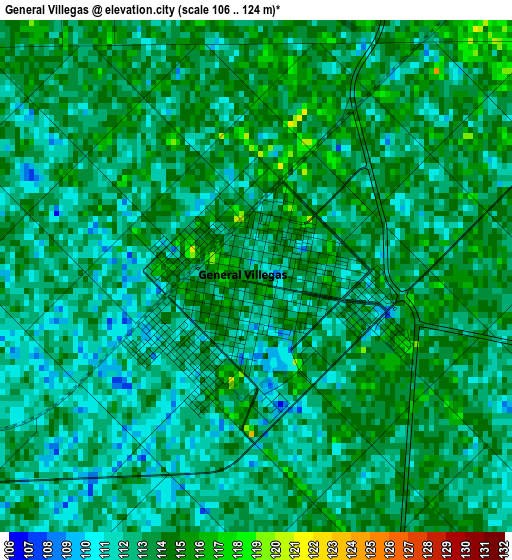
Below is the Elevation map of General Villegas, which displays elevation range with different colors. Scale of the first map is from 106 to 124 m (348 to 407 ft) with average elevation of 112.7 meters (=370 ft) [note 1]
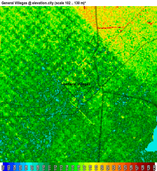
These maps also provides idea of topography and contour of this city, they are displayed at different zoom levels. More info about maps, scale and edge coordinates you can find below images.
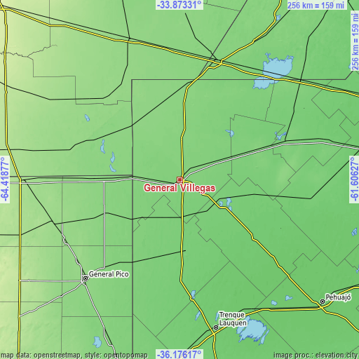
| \ | Map #1 | Map #2 | Topo.Map |
| Scale [m] | 106..124 m | 102..130 m | × |
| Scale [ft] | 348..407 ft | 335..427 ft | × |
| Average | 112.7 m = 370 ft | 113.5 m = 372 ft | × |
| Width | 8 km = 5 mi | 16 km = 9.9 mi | 256.1 km = 159.1 mi |
| Height | 8 km = 5 mi | 16 km = 9.9 mi | 256.1 km = 159.1 mi |
| ↑Max Latitude | -34.996859° | -34.960851° | -33.87331° |
| Latitude at center | -35.03285° | -35.03285° | -35.03285° |
| ↓Min Latitude | -35.068826° | -35.104785° | -36.17617° |
| ← Min Longitude | -63.056465° | -63.100411° | -64.41877° |
| Longitude center | -63.01252° | -63.01252° | -63.01252° |
| →Max Longitude | -62.968575° | -62.924629° | -61.60627° |
Nearby cities:
Cities around General Villegas sort by population:
• General Pico elevation 143 m
96.8 km,  224°
224°
• Rufino 118 m
89.3 km,  17°
17°
• Intendente Alvear 129 m
57.2 km,  247°
247°
• Santa Magdalena 158 m
102.6 km,  303°
303°
• Tres Algarrobos 108 m
28.2 km,  129°
129°
• Serrano 147 m
78.9 km,  322°
322°
• Buchardo 133 m
56.9 km,  307°
307°
• Bernardo Larroudé 127 m
51.9 km,  271°
271°
• Alta Italia 167 m
105.6 km, 251°
• Italó 144 m
75.1 km,  290°
290°
• Carlos Tejedor 96 m
67 km, 126°
• Florentino Ameghino 116 m
54 km,  67°
67°
Multilingual:
 En español:
General Villegas elevación 112 m.
 En France:
General Villegas élévation 112 m.
 Auf Deutsch:
General Villegas höhe über dem Meeresspiegel ist 112 m.

Sources and notes:
- [note 1] Map square and city borders are not equal. Map elevation data is calculated only from area inside that square.
- [src 1] Elevation data from geonames database provided with same terms of usage.
- [src 2] The elevation map of General Villegas is generated using elevation data from NASA's 3 arcsec (90m) resolution SRTM data.
- [src 3] Base (background) map © OpenStreetMap contributors tiles are generated by Geofabrik and OpenTopoMap.
Copyright & License:
This General Villegas Elevation Map is licensed under CC BY-SA. You may reuse any part from this page, if you give a proper credit by linking to this URL:
 More info on terms of use page.