General Pico elevation
General Pico (La Pampa, Departamento de Maracó), Argentina elevation is 143 meters and General Pico elevation in feet is 469 ft above sea level [src 1]. General Pico is a seat of a second-order administrative division (feature code) with elevation that is 207 meters (679 ft) smaller than average city elevation in Argentina.
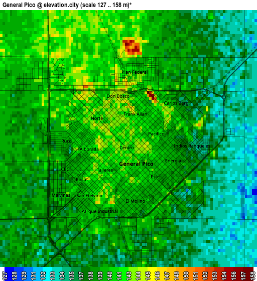
Below is the Elevation map of General Pico, which displays elevation range with different colors. Scale of the first map is from 127 to 158 m (417 to 518 ft) with average elevation of 138.5 meters (=454 ft) [note 1]
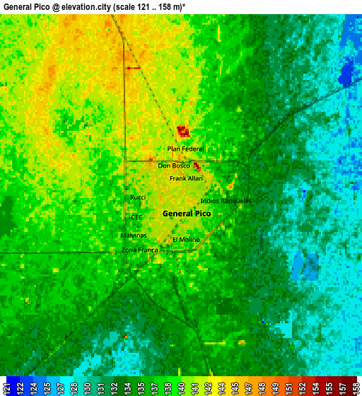
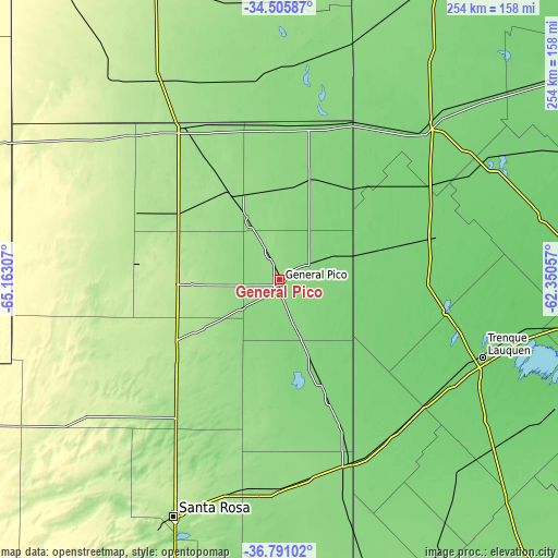
These maps also provides idea of topography and contour of this city, they are displayed at different zoom levels. More info about maps, scale and edge coordinates you can find below images.
| \ | Map #1 | Map #2 | Topo.Map |
| Scale [m] | 127..158 m | 121..158 m | × |
| Scale [ft] | 417..518 ft | 397..518 ft | × |
| Average | 138.5 m = 454 ft | 135.8 m = 446 ft | × |
| Width | 7.94 km = 4.9 mi | 15.88 km = 9.9 mi | 254.1 km = 157.9 mi |
| Height | 7.94 km = 4.9 mi | 15.88 km = 9.9 mi | 254.1 km = 157.9 mi |
| ↑Max Latitude | -35.620905° | -35.585175° | -34.50587° |
| Latitude at center | -35.65662° | -35.65662° | -35.65662° |
| ↓Min Latitude | -35.692319° | -35.728001° | -36.79102° |
| ← Min Longitude | -63.800765° | -63.844711° | -65.16307° |
| Longitude center | -63.75682° | -63.75682° | -63.75682° |
| →Max Longitude | -63.712875° | -63.668929° | -62.35057° |
Nearby cities:
Cities around General Pico sort by population:
• Eduardo Castex elevation 193 m
56.4 km,  239°
239°
• Intendente Alvear 129 m
49.3 km,  17°
17°
• Ingeniero Luiggi 192 m
70.8 km,  295°
295°
• Quemú Quemú 121 m
47.5 km,  158°
158°
• Trenel 179 m
34.2 km,  262°
262°
• Colonia Barón 154 m
55.7 km,  189°
189°
• Winifreda 169 m
76.5 km,  214°
214°
• Caleufú 208 m
72.7 km,  275°
275°
• Bernardo Larroudé 127 m
72 km,  12°
12°
• Alta Italia 167 m
48.4 km,  317°
317°
• Embajador Martini 174 m
56.1 km, 302°
• Arata 217 m
54.2 km,  272°
272°
Multilingual:
 En español:
General Pico elevación 143 m.
 En France:
General Pico élévation 143 m.
 Auf Deutsch:
General Pico höhe über dem Meeresspiegel ist 143 m.

Sources and notes:
- [note 1] Map square and city borders are not equal. Map elevation data is calculated only from area inside that square.
- [src 1] Elevation data from geonames database provided with same terms of usage.
- [src 2] The elevation map of General Pico is generated using elevation data from NASA's 3 arcsec (90m) resolution SRTM data.
- [src 3] Base (background) map © OpenStreetMap contributors tiles are generated by Geofabrik and OpenTopoMap.
Copyright & License:
This General Pico Elevation Map is licensed under CC BY-SA. You may reuse any part from this page, if you give a proper credit by linking to this URL:
 More info on terms of use page.