Ingeniero Guillermo N. Juárez elevation
Ingeniero Guillermo N. Juárez (Formosa, Departamento de Matacos), Argentina elevation is 185 meters and Ingeniero Guillermo N. Juárez elevation in feet is 607 ft above sea level [src 1]. Ingeniero Guillermo N. Juárez is a seat of a second-order administrative division (feature code) with elevation that is 165 meters (541 ft) smaller than average city elevation in Argentina.
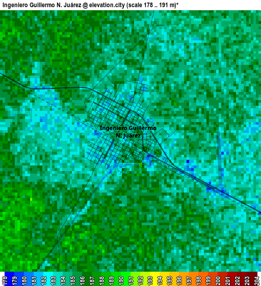
Below is the Elevation map of Ingeniero Guillermo N. Juárez, which displays elevation range with different colors. Scale of the first map is from 178 to 191 m (584 to 627 ft) with average elevation of 184.5 meters (=605 ft) [note 1]
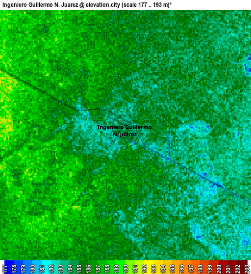
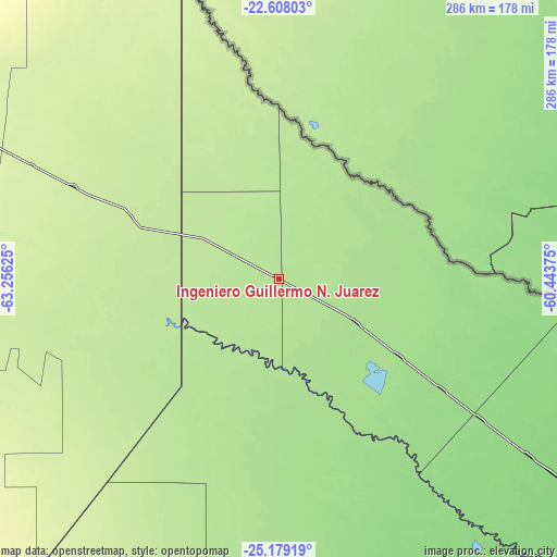
These maps also provides idea of topography and contour of this city, they are displayed at different zoom levels. More info about maps, scale and edge coordinates you can find below images.
| \ | Map #1 | Map #2 | Topo.Map |
| Scale [m] | 178..191 m | 177..193 m | × |
| Scale [ft] | 584..627 ft | 581..633 ft | × |
| Average | 184.5 m = 605 ft | 185 m = 607 ft | × |
| Width | 8.93 km = 5.5 mi | 17.87 km = 11.1 mi | 285.9 km = 177.6 mi |
| Height | 8.93 km = 5.5 mi | 17.87 km = 11.1 mi | 285.9 km = 177.6 mi |
| ↑Max Latitude | -23.859817° | -23.819621° | -22.60803° |
| Latitude at center | -23.9° | -23.9° | -23.9° |
| ↓Min Latitude | -23.940171° | -23.980329° | -25.17919° |
| ← Min Longitude | -61.893945° | -61.937891° | -63.25625° |
| Longitude center | -61.85° | -61.85° | -61.85° |
| →Max Longitude | -61.806055° | -61.762109° | -60.44375° |
Nearby cities:
Cities around Ingeniero Guillermo N. Juárez sort by population:
• Embarcación elevation 292 m
241.8 km,  288°
288°
• General Enrique Mosconi 481 m
247.4 km,  305°
305°
• Las Lomitas 134 m
156 km,  125°
125°
• Ibarreta 107 m
248.8 km, 125°
• Apolinario Saravia 361 m
225.5 km,  254°
254°
• Taco Pozo 261 m
238.4 km,  216°
216°
• Estanislao del Campo 115 m
219.4 km, 125°
• Pozo del Tigre 127 m
190.2 km, 125°
• Laguna Yema 162 m
73 km,  122°
122°
• General Enrique Mosconi 208 m
88.7 km,  328°
328°
• Monte Quemado 224 m
233.8 km,  205°
205°
• Rivadavia 210 m
109.8 km, 253°
Multilingual:
 En español:
Ingeniero Guillermo N. Juárez elevación 185 m.
 En France:
Ingeniero Guillermo N. Juárez élévation 185 m.
 Auf Deutsch:
Ingeniero Guillermo N. Juárez höhe über dem Meeresspiegel ist 185 m.
 На русском:
Ingeniero Guillermo N. Juárez высота над уровнем моря 185 м
Sources and notes:
- [note 1] Map square and city borders are not equal. Map elevation data is calculated only from area inside that square.
- [src 1] Elevation data from geonames database provided with same terms of usage.
- [src 2] The elevation map of Ingeniero Guillermo N. Juárez is generated using elevation data from NASA's 3 arcsec (90m) resolution SRTM data.
- [src 3] Base (background) map © OpenStreetMap contributors tiles are generated by Geofabrik and OpenTopoMap.
Copyright & License:
This Ingeniero Guillermo N. Juárez Elevation Map is licensed under CC BY-SA. You may reuse any part from this page, if you give a proper credit by linking to this URL:
 More info on terms of use page.