Taco Pozo elevation
Taco Pozo (Chaco, Departamento de Almirante Brown), Argentina elevation is 261 meters and Taco Pozo elevation in feet is 856 ft above sea level [src 1]. Taco Pozo is a populated place (feature code) with elevation that is 89 meters (292 ft) smaller than average city elevation in Argentina.
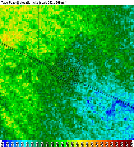
Below is the Elevation map of Taco Pozo, which displays elevation range with different colors. Scale of the first map is from 252 to 269 m (827 to 883 ft) with average elevation of 260.9 meters (=856 ft) [note 1]
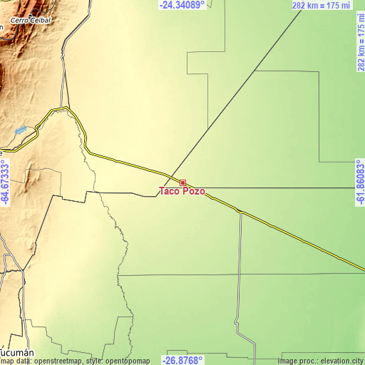
These maps also provides idea of topography and contour of this city, they are displayed at different zoom levels. More info about maps, scale and edge coordinates you can find below images.

| \ | Map #1 | Map #2 | Topo.Map |
| Scale [m] | 252..269 m | 248..276 m | × |
| Scale [ft] | 827..883 ft | 814..906 ft | × |
| Average | 260.9 m = 856 ft | 260.5 m = 855 ft | × |
| Width | 8.81 km = 5.5 mi | 17.62 km = 10.9 mi | 282 km = 175.2 mi |
| Height | 8.81 km = 5.5 mi | 17.62 km = 10.9 mi | 282 km = 175.2 mi |
| ↑Max Latitude | -25.575937° | -25.536291° | -24.34089° |
| Latitude at center | -25.61557° | -25.61557° | -25.61557° |
| ↓Min Latitude | -25.65519° | -25.694796° | -26.8768° |
| ← Min Longitude | -63.311025° | -63.354971° | -64.67333° |
| Longitude center | -63.26708° | -63.26708° | -63.26708° |
| →Max Longitude | -63.223135° | -63.179189° | -61.86083° |
Nearby cities:
Cities around Taco Pozo sort by population:
• Joaquín V. González elevation 362 m
102.8 km,  302°
302°
• El Quebrachal 355 m
88.4 km,  294°
294°
• Las Lajitas 440 m
135.8 km,  316°
316°
• Apolinario Saravia 361 m
150.6 km,  330°
330°
• El Galpón 527 m
141.5 km,  280°
280°
• Campo Gallo 194 m
115.4 km,  158°
158°
• Pampa de los Guanacos 161 m
158.4 km,  115°
115°
• Tintina 166 m
166.6 km, 160°
• El Hoyo 176 m
157.2 km,  178°
178°
• Rivadavia 210 m
163.6 km,  13°
13°
• Nueva Esperanza 324 m
116.8 km,  236°
236°
• Monte Quemado 224 m
48.6 km, 115°
Multilingual:
 En español:
Taco Pozo elevación 261 m.
 En France:
Taco Pozo élévation 261 m.
 Auf Deutsch:
Taco Pozo höhe über dem Meeresspiegel ist 261 m.

Sources and notes:
- [note 1] Map square and city borders are not equal. Map elevation data is calculated only from area inside that square.
- [src 1] Elevation data from geonames database provided with same terms of usage.
- [src 2] The elevation map of Taco Pozo is generated using elevation data from NASA's 3 arcsec (90m) resolution SRTM data.
- [src 3] Base (background) map © OpenStreetMap contributors tiles are generated by Geofabrik and OpenTopoMap.
Copyright & License:
This Taco Pozo Elevation Map is licensed under CC BY-SA. You may reuse any part from this page, if you give a proper credit by linking to this URL:
 More info on terms of use page.