Tintina elevation
Tintina (Santiago del Estero, Departamento de Moreno), Argentina elevation is 166 meters and Tintina elevation in feet is 545 ft above sea level [src 1]. Tintina is a populated place (feature code) with elevation that is 184 meters (604 ft) smaller than average city elevation in Argentina.
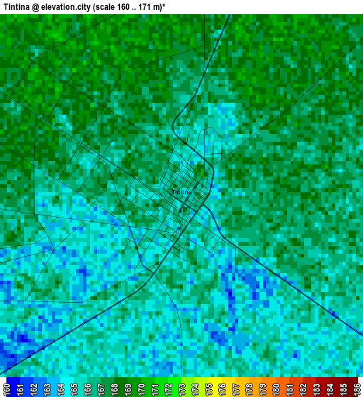
Below is the Elevation map of Tintina, which displays elevation range with different colors. Scale of the first map is from 160 to 171 m (525 to 561 ft) with average elevation of 166 meters (=545 ft) [note 1]
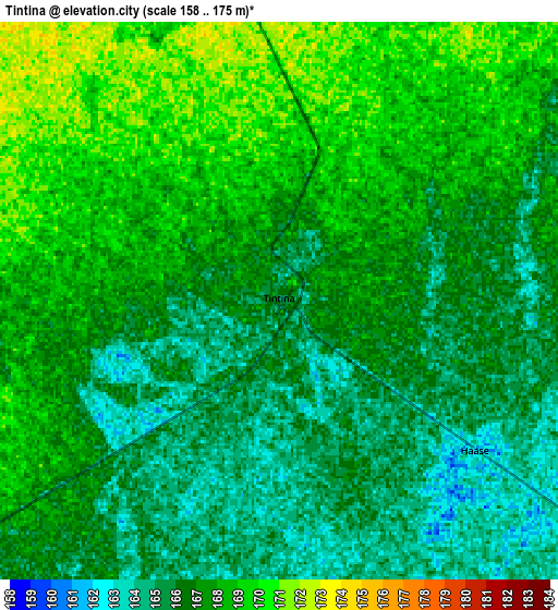
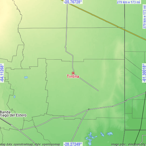
These maps also provides idea of topography and contour of this city, they are displayed at different zoom levels. More info about maps, scale and edge coordinates you can find below images.
| \ | Map #1 | Map #2 | Topo.Map |
| Scale [m] | 160..171 m | 158..175 m | × |
| Scale [ft] | 525..561 ft | 518..574 ft | × |
| Average | 166 m = 545 ft | 166.7 m = 547 ft | × |
| Width | 8.71 km = 5.4 mi | 17.41 km = 10.8 mi | 278.6 km = 173.1 mi |
| Height | 8.71 km = 5.4 mi | 17.41 km = 10.8 mi | 278.6 km = 173.1 mi |
| ↑Max Latitude | -26.987717° | -26.94855° | -25.76728° |
| Latitude at center | -27.02687° | -27.02687° | -27.02687° |
| ↓Min Latitude | -27.066009° | -27.105135° | -28.27249° |
| ← Min Longitude | -62.750375° | -62.794321° | -64.11268° |
| Longitude center | -62.70643° | -62.70643° | -62.70643° |
| →Max Longitude | -62.662485° | -62.618539° | -61.30018° |
Nearby cities:
Cities around Tintina sort by population:
• General Pinedo elevation 95 m
144.4 km,  102°
102°
• Quimilí 135 m
74.6 km,  157°
157°
• Hermoso Campo 86 m
149.3 km,  115°
115°
• Los Frentones 136 m
145.7 km,  61°
61°
• Suncho Corral 135 m
123.5 km,  215°
215°
• Campo Gallo 194 m
51.3 km,  343°
343°
• Pampa de los Guanacos 161 m
123.7 km,  44°
44°
• Gancedo 105 m
114.2 km, 116°
• El Hoyo 176 m
52.1 km,  269°
269°
• Garza 130 m
149.7 km,  213°
213°
• Monte Quemado 224 m
136.3 km,  354°
354°
• La Cañada 156 m
129.8 km,  234°
234°
Multilingual:
 En español:
Tintina elevación 166 m.
 En France:
Tintina élévation 166 m.


Sources and notes:
- [note 1] Map square and city borders are not equal. Map elevation data is calculated only from area inside that square.
- [src 1] Elevation data from geonames database provided with same terms of usage.
- [src 2] The elevation map of Tintina is generated using elevation data from NASA's 3 arcsec (90m) resolution SRTM data.
- [src 3] Base (background) map © OpenStreetMap contributors tiles are generated by Geofabrik and OpenTopoMap.
Copyright & License:
This Tintina Elevation Map is licensed under CC BY-SA. You may reuse any part from this page, if you give a proper credit by linking to this URL:
 More info on terms of use page.