Gancedo elevation
Gancedo (Chaco, Departamento de Doce de Octubre), Argentina elevation is 105 meters and Gancedo elevation in feet is 344 ft above sea level [src 1]. Gancedo is a populated place (feature code) with elevation that is 245 meters (804 ft) smaller than average city elevation in Argentina.
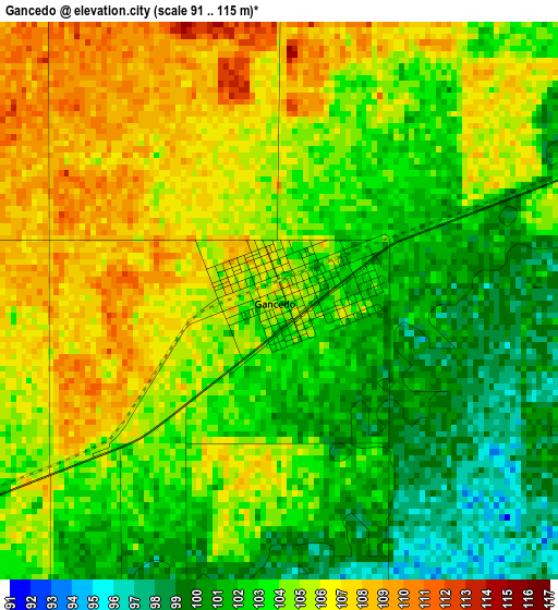
Below is the Elevation map of Gancedo, which displays elevation range with different colors. Scale of the first map is from 91 to 115 m (299 to 377 ft) with average elevation of 103.7 meters (=340 ft) [note 1]
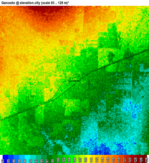
These maps also provides idea of topography and contour of this city, they are displayed at different zoom levels. More info about maps, scale and edge coordinates you can find below images.
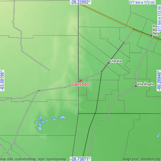
| \ | Map #1 | Map #2 | Topo.Map |
| Scale [m] | 91..115 m | 83..128 m | × |
| Scale [ft] | 299..377 ft | 272..420 ft | × |
| Average | 103.7 m = 340 ft | 104 m = 341 ft | × |
| Width | 8.67 km = 5.4 mi | 17.34 km = 10.8 mi | 277.4 km = 172.4 mi |
| Height | 8.67 km = 5.4 mi | 17.34 km = 10.8 mi | 277.4 km = 172.4 mi |
| ↑Max Latitude | -27.45139° | -27.412386° | -26.23592° |
| Latitude at center | -27.49038° | -27.49038° | -27.49038° |
| ↓Min Latitude | -27.529356° | -27.568319° | -28.73071° |
| ← Min Longitude | -61.719655° | -61.763601° | -63.08196° |
| Longitude center | -61.67571° | -61.67571° | -61.67571° |
| →Max Longitude | -61.631765° | -61.587819° | -60.26946° |
Nearby cities:
Cities around Gancedo sort by population:
• Villa Ángela elevation 79 m
95.2 km,  95°
95°
• Charata 98 m
57.1 km,  57°
57°
• Las Breñas 104 m
73.7 km,  52°
52°
• General Pinedo 95 m
43.3 km, 63°
• San Bernardo 88 m
97.7 km,  76°
76°
• Quimilí 135 m
75 km,  256°
256°
• Corzuela 106 m
91.9 km, 49°
• Coronel Du Graty 82 m
77.9 km,  105°
105°
• Santa Sylvina 77 m
65.3 km,  125°
125°
• Hermoso Campo 86 m
35.2 km, 111°
• Chorotis 76 m
54.5 km,  150°
150°
• Gato Colorado 71 m
76.2 km,  140°
140°
Multilingual:
 En español:
Gancedo elevación 105 m.
 En France:
Gancedo élévation 105 m.


Sources and notes:
- [note 1] Map square and city borders are not equal. Map elevation data is calculated only from area inside that square.
- [src 1] Elevation data from geonames database provided with same terms of usage.
- [src 2] The elevation map of Gancedo is generated using elevation data from NASA's 3 arcsec (90m) resolution SRTM data.
- [src 3] Base (background) map © OpenStreetMap contributors tiles are generated by Geofabrik and OpenTopoMap.
Copyright & License:
This Gancedo Elevation Map is licensed under CC BY-SA. You may reuse any part from this page, if you give a proper credit by linking to this URL:
 More info on terms of use page.