Las Breñas elevation
Las Breñas (Chaco, Departamento de Nueve de Julio), Argentina elevation is 104 meters and Las Breñas elevation in feet is 341 ft above sea level [src 1]. Las Breñas is a seat of a second-order administrative division (feature code) with elevation that is 246 meters (807 ft) smaller than average city elevation in Argentina.
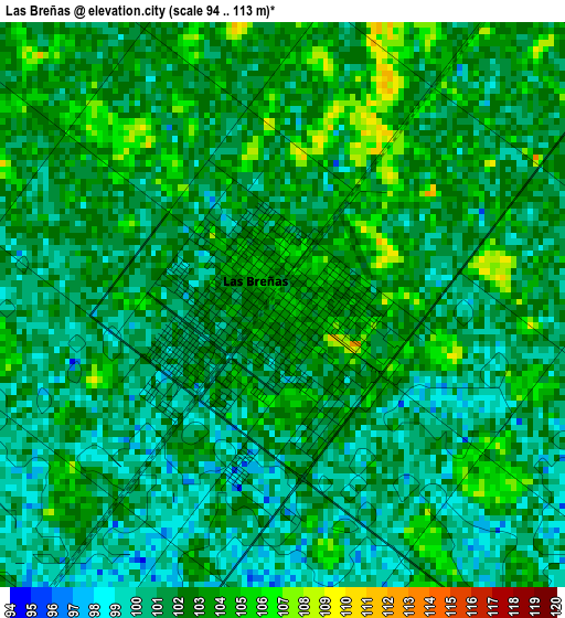
Below is the Elevation map of Las Breñas, which displays elevation range with different colors. Scale of the first map is from 94 to 113 m (308 to 371 ft) with average elevation of 101.7 meters (=334 ft) [note 1]
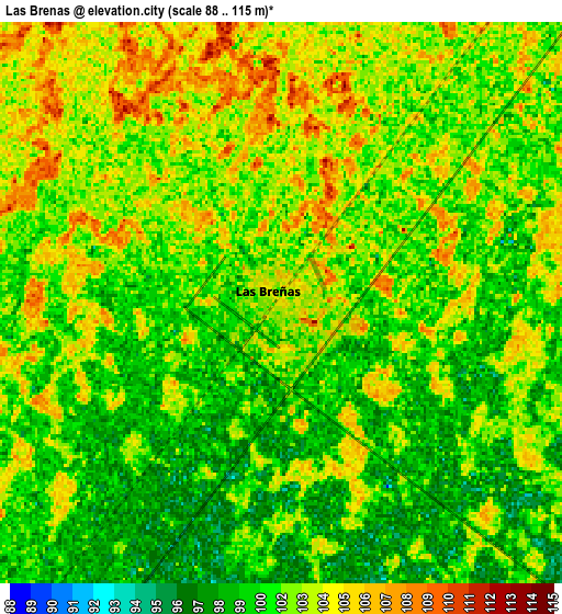
These maps also provides idea of topography and contour of this city, they are displayed at different zoom levels. More info about maps, scale and edge coordinates you can find below images.
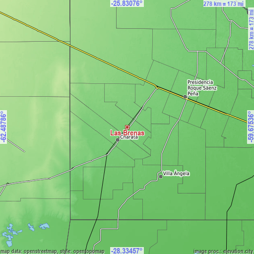
| \ | Map #1 | Map #2 | Topo.Map |
| Scale [m] | 94..113 m | 88..115 m | × |
| Scale [ft] | 308..371 ft | 289..377 ft | × |
| Average | 101.7 m = 334 ft | 101.7 m = 334 ft | × |
| Width | 8.7 km = 5.4 mi | 17.4 km = 10.8 mi | 278.4 km = 173 mi |
| Height | 8.7 km = 5.4 mi | 17.4 km = 10.8 mi | 278.4 km = 173 mi |
| ↑Max Latitude | -27.050529° | -27.011384° | -25.83076° |
| Latitude at center | -27.08966° | -27.08966° | -27.08966° |
| ↓Min Latitude | -27.128777° | -27.167881° | -28.33457° |
| ← Min Longitude | -61.125555° | -61.169501° | -62.48786° |
| Longitude center | -61.08161° | -61.08161° | -61.08161° |
| →Max Longitude | -61.037665° | -60.993719° | -59.67536° |
Nearby cities:
Cities around Las Breñas sort by population:
• Villa Ángela elevation 79 m
64.9 km,  146°
146°
• Charata 98 m
17.4 km,  217°
217°
• General Pinedo 95 m
32.2 km, 218°
• San Bernardo 88 m
42.6 km,  121°
121°
• Campo Largo 106 m
39.9 km,  36°
36°
• Corzuela 106 m
18.8 km, 36°
• Hermoso Campo 86 m
63.2 km,  204°
204°
• Aviá Terai 103 m
56.9 km, 37°
• Concepción del Bermejo 113 m
56.2 km,  13°
13°
• La Tigra 93 m
49 km,  92°
92°
• La Clotilde 94 m
41.4 km,  96°
96°
• Napenay 97 m
60.8 km,  49°
49°
Multilingual:
 En español:
Las Breñas elevación 104 m.
 En France:
Las Breñas élévation 104 m.
 Auf Deutsch:
Las Breñas höhe über dem Meeresspiegel ist 104 m.

Sources and notes:
- [note 1] Map square and city borders are not equal. Map elevation data is calculated only from area inside that square.
- [src 1] Elevation data from geonames database provided with same terms of usage.
- [src 2] The elevation map of Las Breñas is generated using elevation data from NASA's 3 arcsec (90m) resolution SRTM data.
- [src 3] Base (background) map © OpenStreetMap contributors tiles are generated by Geofabrik and OpenTopoMap.
Copyright & License:
This Las Breñas Elevation Map is licensed under CC BY-SA. You may reuse any part from this page, if you give a proper credit by linking to this URL:
 More info on terms of use page.