Campo Gallo elevation
Campo Gallo (Santiago del Estero, Departamento de Alberdi), Argentina elevation is 194 meters and Campo Gallo elevation in feet is 636 ft above sea level [src 1]. Campo Gallo is a seat of a second-order administrative division (feature code) with elevation that is 156 meters (512 ft) smaller than average city elevation in Argentina.
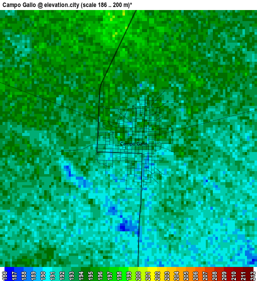
Below is the Elevation map of Campo Gallo, which displays elevation range with different colors. Scale of the first map is from 186 to 200 m (610 to 656 ft) with average elevation of 192.7 meters (=632 ft) [note 1]
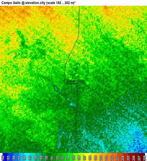
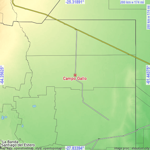
These maps also provides idea of topography and contour of this city, they are displayed at different zoom levels. More info about maps, scale and edge coordinates you can find below images.
| \ | Map #1 | Map #2 | Topo.Map |
| Scale [m] | 186..200 m | 182..202 m | × |
| Scale [ft] | 610..656 ft | 597..663 ft | × |
| Average | 192.7 m = 632 ft | 193 m = 633 ft | × |
| Width | 8.74 km = 5.4 mi | 17.48 km = 10.9 mi | 279.6 km = 173.7 mi |
| Height | 8.74 km = 5.4 mi | 17.48 km = 10.9 mi | 279.7 km = 173.8 mi |
| ↑Max Latitude | -26.544024° | -26.504704° | -25.31891° |
| Latitude at center | -26.58333° | -26.58333° | -26.58333° |
| ↓Min Latitude | -26.622623° | -26.661902° | -27.83394° |
| ← Min Longitude | -62.893945° | -62.937891° | -64.25625° |
| Longitude center | -62.85° | -62.85° | -62.85° |
| →Max Longitude | -62.806055° | -62.762109° | -61.44375° |
Nearby cities:
Cities around Campo Gallo sort by population:
• Quimilí elevation 135 m
125.7 km,  160°
160°
• Taco Pozo 261 m
115.4 km,  338°
338°
• Pampa del Infierno 126 m
166.9 km,  87°
87°
• Los Frentones 136 m
144.3 km,  82°
82°
• Suncho Corral 135 m
160.7 km,  200°
200°
• Pampa de los Guanacos 161 m
108.2 km,  68°
68°
• Tintina 166 m
51.3 km, 163°
• Gancedo 105 m
153.9 km,  130°
130°
• El Hoyo 176 m
62.4 km,  217°
217°
• La Cañada 156 m
154.9 km, 216°
• Nueva Esperanza 324 m
144.7 km,  287°
287°
• Monte Quemado 224 m
86.5 km,  1°
1°
Multilingual:
 En español:
Campo Gallo elevación 194 m.
 En France:
Campo Gallo élévation 194 m.
 Auf Deutsch:
Campo Gallo höhe über dem Meeresspiegel ist 194 m.

Sources and notes:
- [note 1] Map square and city borders are not equal. Map elevation data is calculated only from area inside that square.
- [src 1] Elevation data from geonames database provided with same terms of usage.
- [src 2] The elevation map of Campo Gallo is generated using elevation data from NASA's 3 arcsec (90m) resolution SRTM data.
- [src 3] Base (background) map © OpenStreetMap contributors tiles are generated by Geofabrik and OpenTopoMap.
Copyright & License:
This Campo Gallo Elevation Map is licensed under CC BY-SA. You may reuse any part from this page, if you give a proper credit by linking to this URL:
 More info on terms of use page.