Embarcación elevation
Embarcación (Salta, Departamento de General José de San Martín), Argentina elevation is 292 meters and Embarcación elevation in feet is 958 ft above sea level [src 1]. Embarcación is a populated place (feature code) with elevation that is 58 meters (190 ft) smaller than average city elevation in Argentina.
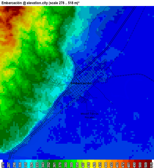
Below is the Elevation map of Embarcación, which displays elevation range with different colors. Scale of the first map is from 278 to 518 m (912 to 1699 ft) with average elevation of 319.8 meters (=1049 ft) [note 1]
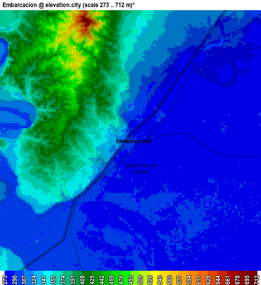
These maps also provides idea of topography and contour of this city, they are displayed at different zoom levels. More info about maps, scale and edge coordinates you can find below images.
| \ | Map #1 | Map #2 | Topo.Map |
| Scale [m] | 278..518 m | 273..712 m | × |
| Scale [ft] | 912..1699 ft | 896..2336 ft | × |
| Average | 319.8 m = 1049 ft | 327.3 m = 1074 ft | × |
| Width | 8.98 km = 5.6 mi | 17.96 km = 11.2 mi | 287.4 km = 178.6 mi |
| Height | 8.98 km = 5.6 mi | 17.96 km = 11.2 mi | 287.4 km = 178.6 mi |
| ↑Max Latitude | -23.169635° | -23.129228° | -21.91143° |
| Latitude at center | -23.21003° | -23.21003° | -23.21003° |
| ↓Min Latitude | -23.250413° | -23.290783° | -24.49613° |
| ← Min Longitude | -64.143595° | -64.187541° | -65.5059° |
| Longitude center | -64.09965° | -64.09965° | -64.09965° |
| →Max Longitude | -64.055705° | -64.011759° | -62.6934° |
Nearby cities:
Cities around Embarcación sort by population:
• San Ramón de la Nueva Orán elevation 358 m
24.4 km,  289°
289°
• Tartagal 499 m
83 km,  21°
21°
• Libertador General San Martín 485 m
96.5 km,  226°
226°
• General Enrique Mosconi 481 m
74.3 km, 23°
• Fraile Pintado 463 m
108.1 km,  221°
221°
• Humahuaca 2970 m
127.8 km,  270°
270°
• Yuto 355 m
61.4 km, 218°
• Caimancito 375 m
77.6 km, 220°
• Palma Sola 664 m
87.8 km,  193°
193°
• Calilegua 468 m
92.7 km, 227°
• Iruya 2810 m
123.5 km, 292°
• Valle Grande 1693 m
91.5 km,  251°
251°
Multilingual:
 En español:
Embarcación elevación 292 m.
 En France:
Embarcación élévation 292 m.
 Auf Deutsch:
Embarcación höhe über dem Meeresspiegel ist 292 m.

Sources and notes:
- [note 1] Map square and city borders are not equal. Map elevation data is calculated only from area inside that square.
- [src 1] Elevation data from geonames database provided with same terms of usage.
- [src 2] The elevation map of Embarcación is generated using elevation data from NASA's 3 arcsec (90m) resolution SRTM data.
- [src 3] Base (background) map © OpenStreetMap contributors tiles are generated by Geofabrik and OpenTopoMap.
Copyright & License:
This Embarcación Elevation Map is licensed under CC BY-SA. You may reuse any part from this page, if you give a proper credit by linking to this URL:
 More info on terms of use page.