Yuto elevation
Yuto (Jujuy, Departamento de Ledesma), Argentina elevation is 355 meters and Yuto elevation in feet is 1165 ft above sea level [src 1]. Yuto is a populated place (feature code) with elevation that is 5 meters (16 ft) bigger than average city elevation in Argentina.
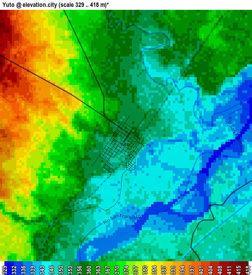
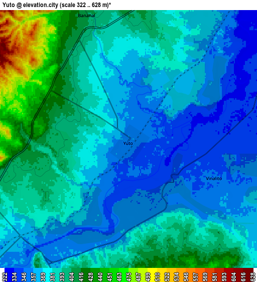
Below is the Elevation map of Yuto, which displays elevation range with different colors. Scale of the first map is from 329 to 418 m (1079 to 1371 ft) with average elevation of 359.6 meters (=1180 ft) [note 1]
These maps also provides idea of topography and contour of this city, they are displayed at different zoom levels. More info about maps, scale and edge coordinates you can find below images.
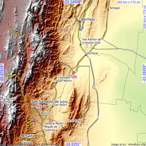
| \ | Map #1 | Map #2 | Topo.Map |
| Scale [m] | 329..418 m | 322..628 m | × |
| Scale [ft] | 1079..1371 ft | 1056..2060 ft | × |
| Average | 359.6 m = 1180 ft | 381.3 m = 1251 ft | × |
| Width | 8.95 km = 5.6 mi | 17.9 km = 11.1 mi | 286.5 km = 178 mi |
| Height | 8.95 km = 5.6 mi | 17.9 km = 11.1 mi | 286.5 km = 178 mi |
| ↑Max Latitude | -23.603157° | -23.562882° | -22.34896° |
| Latitude at center | -23.64342° | -23.64342° | -23.64342° |
| ↓Min Latitude | -23.68367° | -23.723908° | -24.9252° |
| ← Min Longitude | -64.515885° | -64.559831° | -65.87819° |
| Longitude center | -64.47194° | -64.47194° | -64.47194° |
| →Max Longitude | -64.427995° | -64.384049° | -63.06569° |
Nearby cities:
Cities around Yuto sort by population:
• San Ramón de la Nueva Orán elevation 358 m
58.3 km,  14°
14°
• San Pedro de Jujuy 587 m
76.7 km,  211°
211°
• Libertador General San Martín 485 m
36.9 km,  240°
240°
• Embarcación 292 m
61.4 km,  38°
38°
• Fraile Pintado 463 m
46.9 km,  225°
225°
• Caimancito 375 m
16.5 km, 228°
• Palma Sola 664 m
40.9 km,  155°
155°
• Calilegua 468 m
33.6 km, 244°
• Ingenio La Esperanza 557 m
74.7 km, 209°
• Santa Clara 573 m
76.5 km,  194°
194°
• La Mendieta 735 m
89.6 km, 213°
• Valle Grande 1693 m
52 km,  290°
290°
Multilingual:
 En español:
Yuto elevación 355 m.
 En France:
Yuto élévation 355 m.


Sources and notes:
- [note 1] Map square and city borders are not equal. Map elevation data is calculated only from area inside that square.
- [src 1] Elevation data from geonames database provided with same terms of usage.
- [src 2] The elevation map of Yuto is generated using elevation data from NASA's 3 arcsec (90m) resolution SRTM data.
- [src 3] Base (background) map © OpenStreetMap contributors tiles are generated by Geofabrik and OpenTopoMap.
Copyright & License:
This Yuto Elevation Map is licensed under CC BY-SA. You may reuse any part from this page, if you give a proper credit by linking to this URL:
 More info on terms of use page.