Iruya elevation
Iruya (Salta, Departamento de Iruya), Argentina elevation is 2810 meters and Iruya elevation in feet is 9219 ft above sea level [src 1]. Iruya is a seat of a second-order administrative division (feature code) with elevation that is 2460 meters (8071 ft) bigger than average city elevation in Argentina.
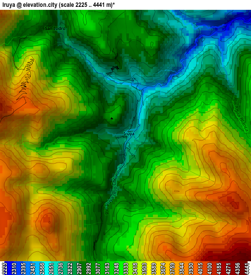
Below is the Elevation map of Iruya, which displays elevation range with different colors. Scale of the first map is from 2225 to 4441 m (7300 to 14570 ft) with average elevation of 3286.5 meters (=10782 ft) [note 1]
These maps also provides idea of topography and contour of this city, they are displayed at different zoom levels. More info about maps, scale and edge coordinates you can find below images.

| \ | Map #1 | Topo.Map |
| Scale [m] | 2225..4441 m | × |
| Scale [ft] | 7300..14570 ft | × |
| Average | 3286.5 m = 10782 ft | × |
| Width | 9.01 km = 5.6 mi | 288.3 km = 179.1 mi |
| Height | 9.01 km = 5.6 mi | 288.3 km = 179.1 mi |
| ↑Max Latitude | -22.75137° | -21.48937° |
| Latitude at center | -22.79189° | -22.79189° |
| ↓Min Latitude | -22.832398° | -24.08208° |
| ← Min Longitude | -65.260975° | -66.62328° |
| Longitude center | -65.21703° | -65.21703° |
| →Max Longitude | -65.173085° | -63.81078° |
Nearby cities:
Cities around Iruya sort by population:
• San Ramón de la Nueva Orán elevation 358 m
99.1 km,  112°
112°
• Libertador General San Martín 485 m
121 km,  158°
158°
• La Quiaca 3451 m
85.9 km,  333°
333°
• Humahuaca 2970 m
48 km,  196°
196°
• Abra Pampa 3487 m
49.8 km,  279°
279°
• Tilcara 3180 m
89.3 km,  191°
191°
• Calilegua 468 m
118.3 km, 157°
• El Aguilar 4040 m
66.8 km,  225°
225°
• Maimará 2397 m
94.5 km, 191°
• Rinconada 3915 m
105.1 km,  291°
291°
• Valle Grande 1693 m
80.9 km, 160°
• Santa Victoria 2378 m
65.4 km,  23°
23°
Multilingual:
 En español:
Iruya elevación 2810 m.
 En France:
Iruya élévation 2810 m.


Sources and notes:
- [note 1] Map square and city borders are not equal. Map elevation data is calculated only from area inside that square.
- [src 1] Elevation data from geonames database provided with same terms of usage.
- [src 2] The elevation map of Iruya is generated using elevation data from NASA's 3 arcsec (90m) resolution SRTM data.
- [src 3] Base (background) map © OpenStreetMap contributors tiles are generated by Geofabrik and OpenTopoMap.
Copyright & License:
This Iruya Elevation Map is licensed under CC BY-SA. You may reuse any part from this page, if you give a proper credit by linking to this URL:
 More info on terms of use page.