Tilcara elevation
Tilcara (Jujuy, Departamento de Tilcara), Argentina elevation is 3180 meters and Tilcara elevation in feet is 10433 ft above sea level [src 1]. Tilcara is a seat of a second-order administrative division (feature code) with elevation that is 2830 meters (9285 ft) bigger than average city elevation in Argentina.
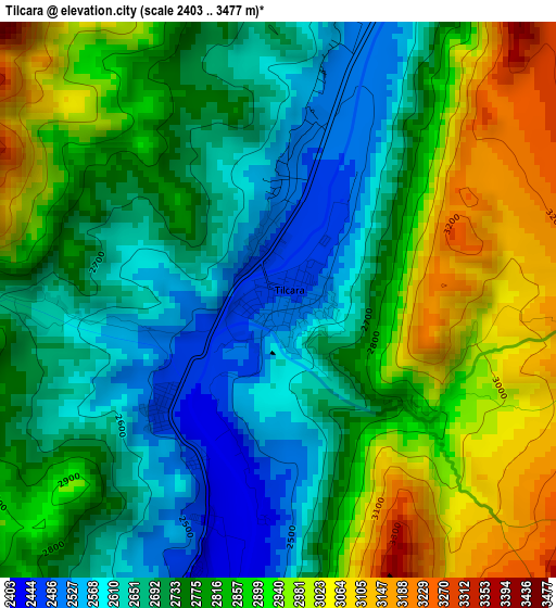
Below is the Elevation map of Tilcara, which displays elevation range with different colors. Scale of the first map is from 2403 to 3477 m (7884 to 11407 ft) with average elevation of 2792.7 meters (=9162 ft) [note 1]
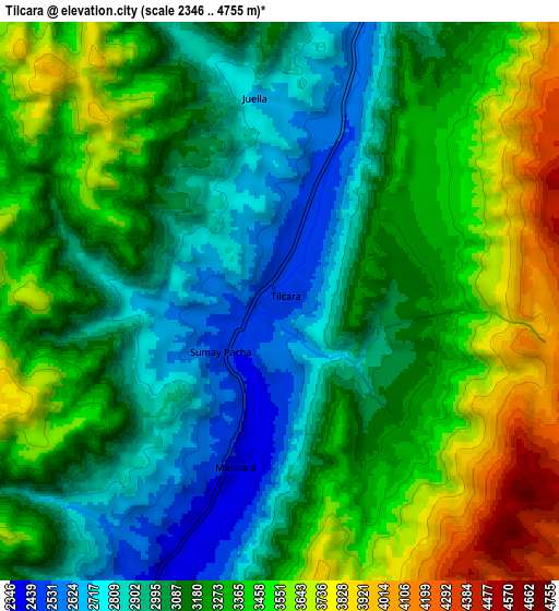
These maps also provides idea of topography and contour of this city, they are displayed at different zoom levels. More info about maps, scale and edge coordinates you can find below images.
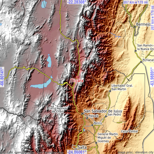
| \ | Map #1 | Map #2 | Topo.Map |
| Scale [m] | 2403..3477 m | 2346..4755 m | × |
| Scale [ft] | 7884..11407 ft | 7697..15600 ft | × |
| Average | 2792.7 m = 9162 ft | 3216.9 m = 10554 ft | × |
| Width | 8.96 km = 5.6 mi | 17.91 km = 11.1 mi | 286.6 km = 178.1 mi |
| Height | 8.96 km = 5.6 mi | 17.91 km = 11.1 mi | 286.6 km = 178.1 mi |
| ↑Max Latitude | -23.537887° | -23.497592° | -22.28308° |
| Latitude at center | -23.57817° | -23.57817° | -23.57817° |
| ↓Min Latitude | -23.61844° | -23.658698° | -24.86061° |
| ← Min Longitude | -65.439105° | -65.483051° | -66.80141° |
| Longitude center | -65.39516° | -65.39516° | -65.39516° |
| →Max Longitude | -65.351215° | -65.307269° | -63.98891° |
Nearby cities:
Cities around Tilcara sort by population:
• San Salvador de Jujuy elevation 1260 m
69.3 km,  171°
171°
• Libertador General San Martín 485 m
66.9 km,  112°
112°
• Palpalá 1126 m
77.7 km, 166°
• Fraile Pintado 463 m
72.8 km,  123°
123°
• Humahuaca 2970 m
41.7 km,  6°
6°
• Caimancito 375 m
83.6 km,  102°
102°
• Calilegua 468 m
67.3 km, 108°
• El Aguilar 4040 m
49.7 km,  324°
324°
• Maimará 2397 m
5.3 km,  194°
194°
• San Antonio 1350 m
88 km,  175°
175°
• Valle Grande 1693 m
47 km,  76°
76°
• Tumbaya 2205 m
32 km, 193°
Multilingual:
 En español:
Tilcara elevación 3180 m.
 En France:
Tilcara élévation 3180 m.
 Auf Deutsch:
Tilcara höhe über dem Meeresspiegel ist 3180 m.

Sources and notes:
- [note 1] Map square and city borders are not equal. Map elevation data is calculated only from area inside that square.
- [src 1] Elevation data from geonames database provided with same terms of usage.
- [src 2] The elevation map of Tilcara is generated using elevation data from NASA's 3 arcsec (90m) resolution SRTM data.
- [src 3] Base (background) map © OpenStreetMap contributors tiles are generated by Geofabrik and OpenTopoMap.
Copyright & License:
This Tilcara Elevation Map is licensed under CC BY-SA. You may reuse any part from this page, if you give a proper credit by linking to this URL:
 More info on terms of use page.