Palpalá elevation
Palpalá (Jujuy, Departamento de Palpalá), Argentina elevation is 1126 meters and Palpalá elevation in feet is 3694 ft above sea level [src 1]. Palpalá is a seat of a second-order administrative division (feature code) with elevation that is 776 meters (2546 ft) bigger than average city elevation in Argentina.
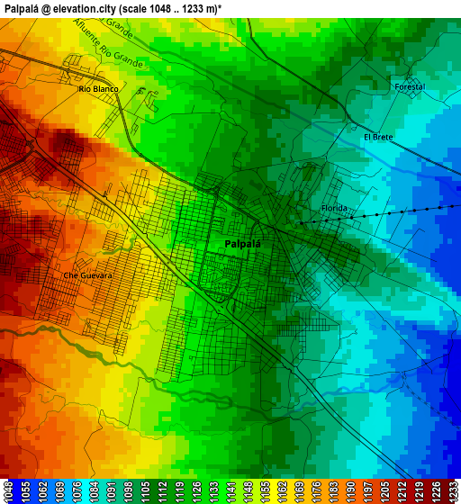
Below is the Elevation map of Palpalá, which displays elevation range with different colors. Scale of the first map is from 1048 to 1233 m (3438 to 4045 ft) with average elevation of 1129.4 meters (=3705 ft) [note 1]
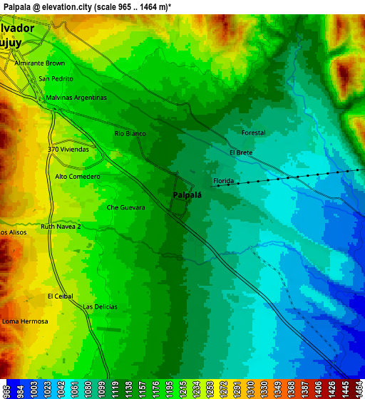
These maps also provides idea of topography and contour of this city, they are displayed at different zoom levels. More info about maps, scale and edge coordinates you can find below images.
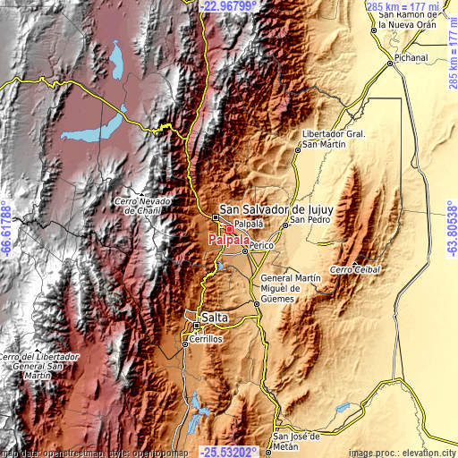
| \ | Map #1 | Map #2 | Topo.Map |
| Scale [m] | 1048..1233 m | 965..1464 m | × |
| Scale [ft] | 3438..4045 ft | 3166..4803 ft | × |
| Average | 1129.4 m = 3705 ft | 1158.3 m = 3800 ft | × |
| Width | 8.91 km = 5.5 mi | 17.82 km = 11.1 mi | 285.1 km = 177.2 mi |
| Height | 8.91 km = 5.5 mi | 17.82 km = 11.1 mi | 285.1 km = 177.2 mi |
| ↑Max Latitude | -24.216398° | -24.176314° | -22.96799° |
| Latitude at center | -24.25647° | -24.25647° | -24.25647° |
| ↓Min Latitude | -24.296529° | -24.336576° | -25.53202° |
| ← Min Longitude | -65.255575° | -65.299521° | -66.61788° |
| Longitude center | -65.21163° | -65.21163° | -65.21163° |
| →Max Longitude | -65.167685° | -65.123739° | -63.80538° |
Nearby cities:
Cities around Palpalá sort by population:
• Salta elevation 1183 m
62.2 km,  198°
198°
• San Salvador de Jujuy 1260 m
11.1 km,  308°
308°
• San Pedro de Jujuy 587 m
35.1 km,  85°
85°
• Fraile Pintado 463 m
54.6 km,  50°
50°
• Ingenio La Esperanza 557 m
37.9 km,  84°
84°
• Santa Clara 573 m
56 km,  96°
96°
• La Mendieta 735 m
25.9 km, 103°
• Tumbaya 2205 m
51.3 km,  329°
329°
• General Martín Miguel de Güemes 742 m
48.9 km,  160°
160°
• La Caldera 1389 m
42.4 km, 203°
• San Antonio 1350 m
17.6 km,  225°
225°
• El Carmen 1178 m
15.4 km, 199°
Multilingual:
 En español:
Palpalá elevación 1126 m.
 En France:
Palpalá élévation 1126 m.
 Auf Deutsch:
Palpalá höhe über dem Meeresspiegel ist 1126 m.

Sources and notes:
- [note 1] Map square and city borders are not equal. Map elevation data is calculated only from area inside that square.
- [src 1] Elevation data from geonames database provided with same terms of usage.
- [src 2] The elevation map of Palpalá is generated using elevation data from NASA's 3 arcsec (90m) resolution SRTM data.
- [src 3] Base (background) map © OpenStreetMap contributors tiles are generated by Geofabrik and OpenTopoMap.
Copyright & License:
This Palpalá Elevation Map is licensed under CC BY-SA. You may reuse any part from this page, if you give a proper credit by linking to this URL:
 More info on terms of use page.